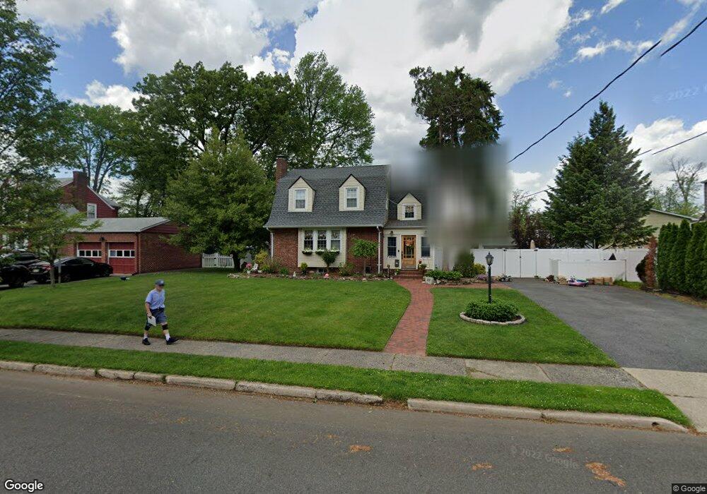
67 N Leswing Ave Saddle Brook, NJ 07663
Estimated Value: $609,307 - $699,000
3
Beds
2
Baths
1,563
Sq Ft
$422/Sq Ft
Est. Value
About This Home
This home is located at 67 N Leswing Ave, Saddle Brook, NJ 07663 and is currently estimated at $658,827, approximately $421 per square foot. 67 N Leswing Ave is a home located in Bergen County with nearby schools including Saddle Brook Mid High School.
Ownership History
Date
Name
Owned For
Owner Type
Purchase Details
Closed on
Aug 18, 2017
Sold by
Albanese Patricia and Albanese Joseph
Bought by
Lindsay Michelle
Current Estimated Value
Home Financials for this Owner
Home Financials are based on the most recent Mortgage that was taken out on this home.
Original Mortgage
$300,000
Outstanding Balance
$250,327
Interest Rate
3.96%
Mortgage Type
Purchase Money Mortgage
Estimated Equity
$408,500
Purchase Details
Closed on
Oct 28, 2004
Sold by
Rimasse Marie
Bought by
Albanese Joseph and Albanese Patricia
Home Financials for this Owner
Home Financials are based on the most recent Mortgage that was taken out on this home.
Original Mortgage
$330,000
Interest Rate
5.71%
Create a Home Valuation Report for This Property
The Home Valuation Report is an in-depth analysis detailing your home's value as well as a comparison with similar homes in the area
Home Values in the Area
Average Home Value in this Area
Purchase History
| Date | Buyer | Sale Price | Title Company |
|---|---|---|---|
| Lindsay Michelle | $391,000 | None Available | |
| Albanese Joseph | $355,000 | -- |
Source: Public Records
Mortgage History
| Date | Status | Borrower | Loan Amount |
|---|---|---|---|
| Open | Lindsay Michelle | $300,000 | |
| Previous Owner | Albanese Joseph | $330,000 |
Source: Public Records
Tax History Compared to Growth
Tax History
| Year | Tax Paid | Tax Assessment Tax Assessment Total Assessment is a certain percentage of the fair market value that is determined by local assessors to be the total taxable value of land and additions on the property. | Land | Improvement |
|---|---|---|---|---|
| 2025 | $10,511 | $461,000 | $236,000 | $225,000 |
| 2024 | $9,872 | $455,800 | $231,200 | $224,600 |
| 2023 | $9,642 | $422,600 | $208,900 | $213,700 |
| 2022 | $9,642 | $401,400 | $197,400 | $204,000 |
| 2021 | $9,666 | $371,200 | $181,700 | $189,500 |
| 2020 | $9,319 | $361,900 | $178,400 | $183,500 |
| 2019 | $9,252 | $356,800 | $176,900 | $179,900 |
| 2018 | $9,060 | $357,100 | $178,400 | $178,700 |
| 2017 | $8,824 | $342,300 | $176,000 | $166,300 |
| 2016 | $8,558 | $298,700 | $168,900 | $129,800 |
| 2015 | $8,110 | $298,700 | $168,900 | $129,800 |
| 2014 | $7,826 | $298,700 | $168,900 | $129,800 |
Source: Public Records
Map
Nearby Homes
- 23 Liberty St
- 485 Saddle River Rd Unit 1
- 21 Kuhn Ct
- 54 Rochelle Pkwy
- 16 Sherry Ln Unit 38
- 39 Sampson St
- 27 Sampson St Unit 2
- 173 Howard Ave
- 66 Hahn Ave
- 214 Colonial Ave
- 59 Chelsea Ct Unit O59
- 393 Rugby Rd
- 43 Hoffman Ave
- 64 Alberta Dr
- 194 Saddle River Rd
- 77 Graham Terrace
- 484 Sylvan St
- 132 Cory Ln Unit C0132
- 26 Parker Ave
- 502 Sylvan St
- 73 N Leswing Ave
- 22 Liberty St
- 98 Lincoln Ave
- 70 N Leswing Ave
- 100 Lincoln Ave
- 18 Liberty St
- 76 N Leswing Ave
- 414 Liberty St
- 395 Liberty St
- 102 Lincoln Ave
- 82 N Leswing Ave
- 85 N Leswing Ave
- 69 S Leswing Ave
- 21 Liberty St
- 75 S Leswing Ave
- 104 Lincoln Ave
- 19 Liberty St
- 88 N Leswing Ave
- 95 Lincoln Ave
- 97 Lincoln Ave