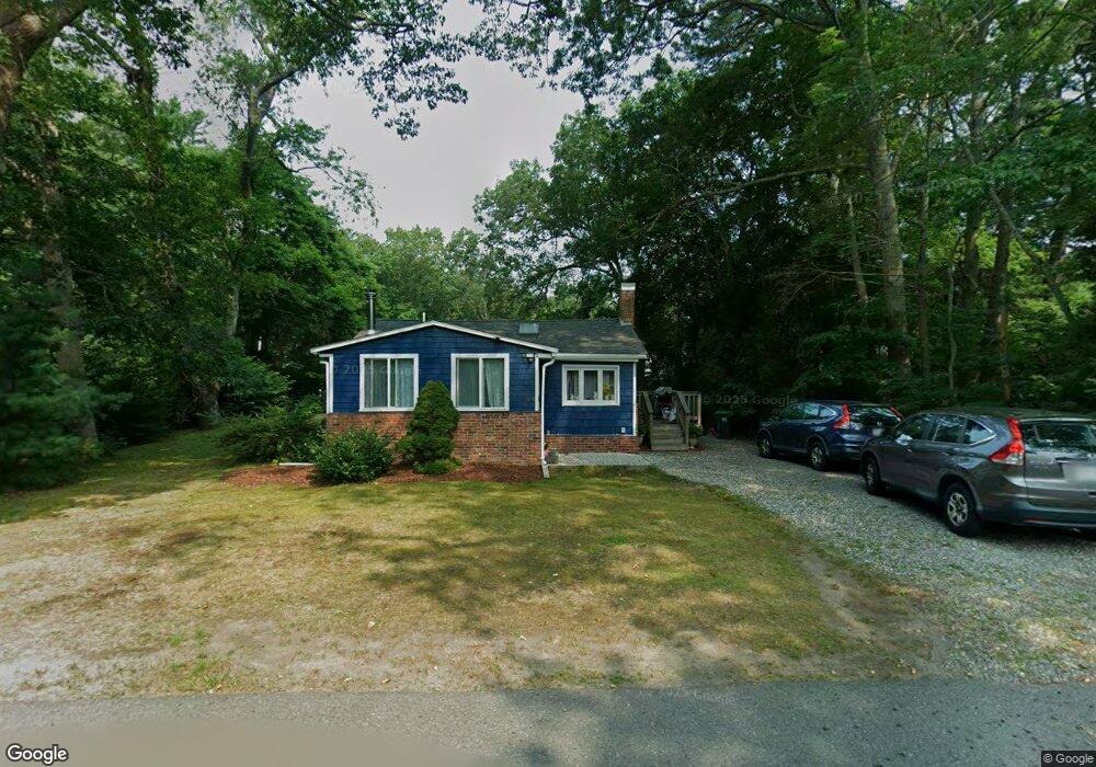
67 Nantasket St Marshfield, MA 02050
Estimated Value: $464,442 - $524,000
2
Beds
2
Baths
802
Sq Ft
$614/Sq Ft
Est. Value
About This Home
This home is located at 67 Nantasket St, Marshfield, MA 02050 and is currently estimated at $492,111, approximately $613 per square foot. 67 Nantasket St is a home located in Plymouth County with nearby schools including South River, Furnace Brook Middle School, and Marshfield High School.
Ownership History
Date
Name
Owned For
Owner Type
Purchase Details
Closed on
Aug 30, 2002
Sold by
Carrara Rt
Bought by
Flynn Michael O and Flynn Julieanne R
Current Estimated Value
Home Financials for this Owner
Home Financials are based on the most recent Mortgage that was taken out on this home.
Original Mortgage
$191,835
Interest Rate
6.55%
Mortgage Type
Purchase Money Mortgage
Purchase Details
Closed on
Mar 30, 2000
Sold by
Pidgeon Nelson E
Bought by
Carrara Scott F
Purchase Details
Closed on
Aug 16, 1995
Sold by
Kolbe Laurence A and Kolbe Kendall S
Bought by
Pidgeon Nelson E
Purchase Details
Closed on
Apr 21, 1993
Sold by
Carey Anna M
Bought by
Kolbe Laurence A and Kolbe Kendall S
Create a Home Valuation Report for This Property
The Home Valuation Report is an in-depth analysis detailing your home's value as well as a comparison with similar homes in the area
Home Values in the Area
Average Home Value in this Area
Purchase History
| Date | Buyer | Sale Price | Title Company |
|---|---|---|---|
| Flynn Michael O | $210,000 | -- | |
| Flynn Michael O | $210,000 | -- | |
| Carrara Scott F | $135,900 | -- | |
| Carrara Scott F | $135,900 | -- | |
| Pidgeon Nelson E | $90,000 | -- | |
| Pidgeon Nelson E | $90,000 | -- | |
| Kolbe Laurence A | $40,000 | -- |
Source: Public Records
Mortgage History
| Date | Status | Borrower | Loan Amount |
|---|---|---|---|
| Open | Kolbe Laurence A | $192,000 | |
| Closed | Kolbe Laurence A | $191,835 |
Source: Public Records
Tax History Compared to Growth
Tax History
| Year | Tax Paid | Tax Assessment Tax Assessment Total Assessment is a certain percentage of the fair market value that is determined by local assessors to be the total taxable value of land and additions on the property. | Land | Improvement |
|---|---|---|---|---|
| 2025 | $3,764 | $380,200 | $260,000 | $120,200 |
| 2024 | $3,767 | $362,600 | $250,000 | $112,600 |
| 2023 | $3,656 | $322,500 | $230,000 | $92,500 |
| 2022 | $3,656 | $282,300 | $198,000 | $84,300 |
| 2021 | $3,622 | $274,600 | $198,000 | $76,600 |
| 2020 | $3,237 | $242,800 | $170,000 | $72,800 |
| 2019 | $3,196 | $238,900 | $170,000 | $68,900 |
| 2018 | $3,114 | $232,900 | $164,000 | $68,900 |
| 2017 | $3,051 | $222,400 | $164,000 | $58,400 |
| 2016 | $3,087 | $222,400 | $164,000 | $58,400 |
| 2015 | $2,956 | $222,400 | $164,000 | $58,400 |
| 2014 | $2,957 | $222,500 | $164,000 | $58,500 |
Source: Public Records
Map
Nearby Homes
- 61 Nantasket St
- 77 Nantasket St
- 70 Revere St
- 78 Revere St
- 51 Nantasket St
- 51 Nantasket St Unit 51
- 76 Nantasket St
- 76 Nantasket St Unit 1
- 60 Nantasket St
- 132 Washington Ave
- 88 Nantasket St
- 122 Washington Ave
- 75 Revere St
- 134 Wellington Ave
- 110 Washington Ave
- 92 Nantasket St
- 123 Washington Ave
- 100 Washington Ave
- 141 Washington Ave
- 85 Rockport St