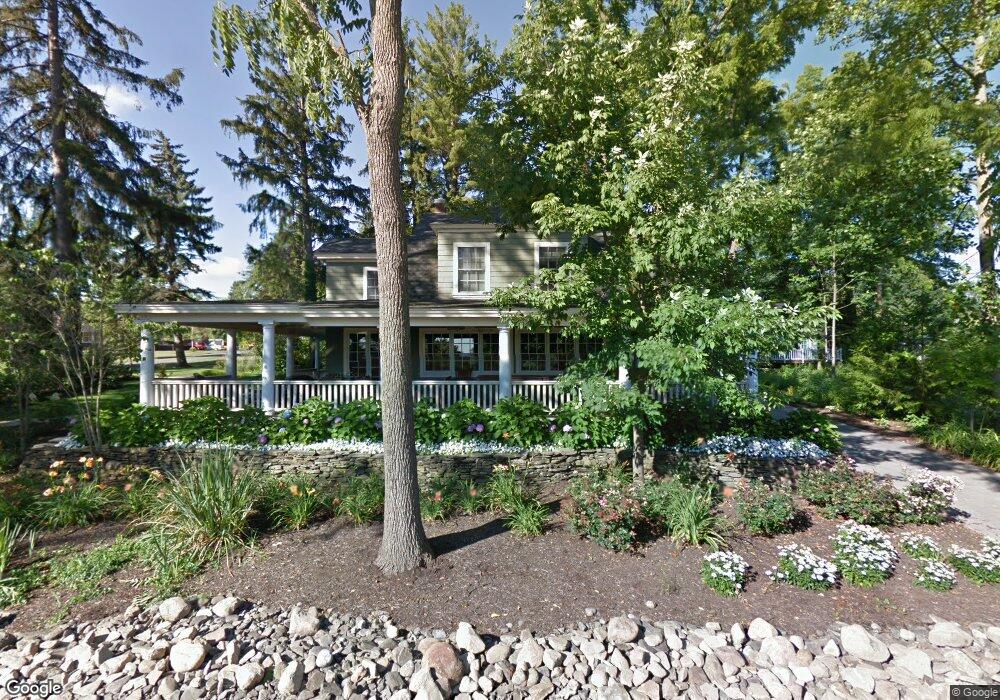
67 Pratt Ave Chautauqua, NY 14722
Estimated Value: $1,361,000 - $1,601,000
7
Beds
5
Baths
3,963
Sq Ft
$381/Sq Ft
Est. Value
About This Home
This home is located at 67 Pratt Ave, Chautauqua, NY 14722 and is currently estimated at $1,509,619, approximately $380 per square foot. 67 Pratt Ave is a home with nearby schools including Chautauqua Lake Elementary School and Chautauqua Lake Secondary School.
Ownership History
Date
Name
Owned For
Owner Type
Purchase Details
Closed on
Oct 30, 2006
Sold by
Brewer Nancy
Bought by
Koschik David
Current Estimated Value
Home Financials for this Owner
Home Financials are based on the most recent Mortgage that was taken out on this home.
Original Mortgage
$666,000
Outstanding Balance
$209,563
Interest Rate
6.48%
Mortgage Type
Purchase Money Mortgage
Estimated Equity
$1,300,056
Purchase Details
Closed on
Jun 7, 2002
Sold by
Brewer Nancy
Bought by
Brewer Nancy
Purchase Details
Closed on
Sep 1, 1998
Sold by
Burke Pamela
Bought by
Brewer Nancy E
Create a Home Valuation Report for This Property
The Home Valuation Report is an in-depth analysis detailing your home's value as well as a comparison with similar homes in the area
Home Values in the Area
Average Home Value in this Area
Purchase History
| Date | Buyer | Sale Price | Title Company |
|---|---|---|---|
| Koschik David | $932,500 | Mark Bargar | |
| Brewer Nancy | -- | Mark Hampton | |
| Brewer Nancy E | $500,000 | -- |
Source: Public Records
Mortgage History
| Date | Status | Borrower | Loan Amount |
|---|---|---|---|
| Open | Koschik David | $666,000 |
Source: Public Records
Tax History Compared to Growth
Tax History
| Year | Tax Paid | Tax Assessment Tax Assessment Total Assessment is a certain percentage of the fair market value that is determined by local assessors to be the total taxable value of land and additions on the property. | Land | Improvement |
|---|---|---|---|---|
| 2024 | $9,003 | $1,039,000 | $268,600 | $770,400 |
| 2023 | $19,629 | $1,039,000 | $268,600 | $770,400 |
| 2022 | $19,867 | $1,039,000 | $268,600 | $770,400 |
| 2021 | $20,071 | $1,039,000 | $268,600 | $770,400 |
| 2020 | $21,858 | $1,039,000 | $477,600 | $561,400 |
| 2019 | $21,462 | $1,039,000 | $477,600 | $561,400 |
| 2018 | $21,462 | $1,039,000 | $477,600 | $561,400 |
| 2017 | $20,994 | $1,039,000 | $477,600 | $561,400 |
| 2016 | $20,815 | $1,039,000 | $477,600 | $561,400 |
| 2015 | -- | $1,039,000 | $477,600 | $561,400 |
| 2014 | -- | $980,300 | $477,600 | $502,700 |
Source: Public Records
Map
Nearby Homes
- 83 Pratt Ave
- 86 Hedding Ave
- 15 Root Ave
- 2 Elm Ln
- 37 Scott Ave
- 29 Whitfield Ave
- 18 Ames Ave
- 2025 (Lot #10) Mandolin Ridge
- 2094 (Lot #56) Mandolin Ridge Way
- 3030 (Lot 3) Mandolin Ridge Way
- 3037 (Lot 39) Mandolin Ridge Way
- 3025 (Lot 35) Mandolin Ridge Way
- 3021 (Lot 34) Mandolin Ridge Way
- 3017 (Lot 33) Mandolin Ridge Way
- 3033 (Lot 38) Mandolin Ridge Way
- 3013 (Lot 32) Mandolin Ridge Way
- 2014 (Lot 44) Mandolin Ridge Way
- 2018 (Lot 45) Mandolin Ridge Way
- 3038 (Lot 1) Mandolin Ridge Way
- 2017 (Lot 8) Mandolin Ridge Way