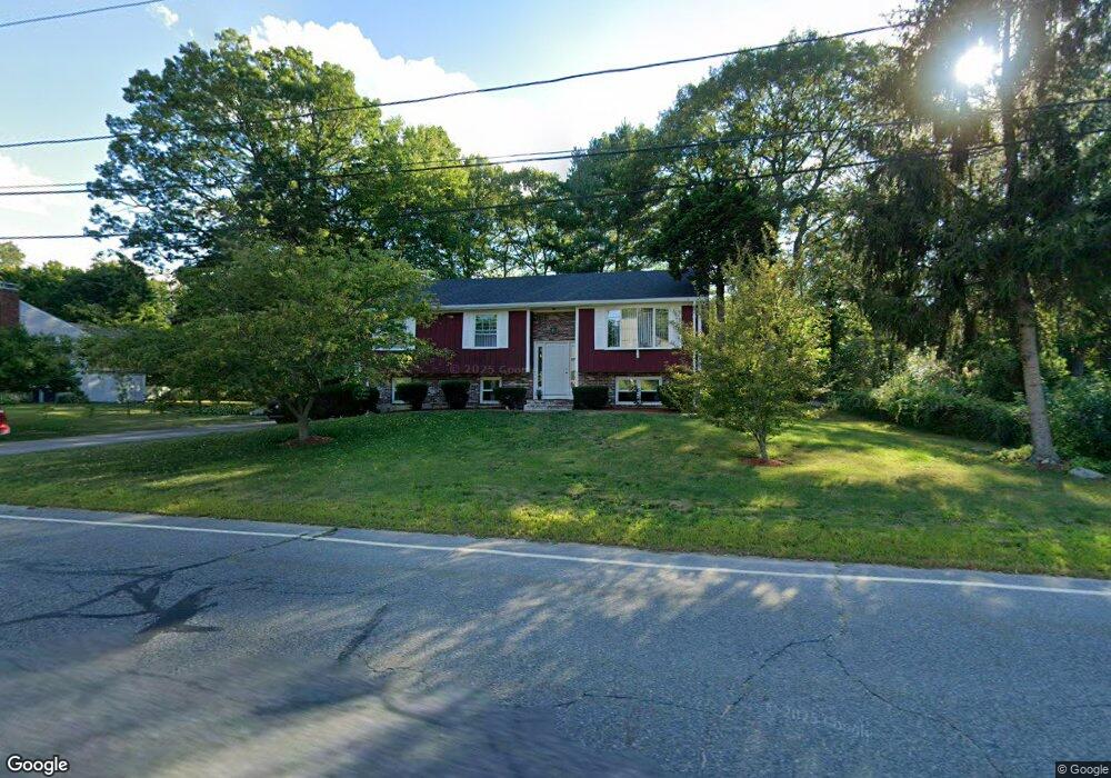
67 Rome Blvd Attleboro, MA 02703
Estimated Value: $449,000 - $569,000
3
Beds
2
Baths
1,132
Sq Ft
$454/Sq Ft
Est. Value
About This Home
This home is located at 67 Rome Blvd, Attleboro, MA 02703 and is currently estimated at $514,031, approximately $454 per square foot. 67 Rome Blvd is a home located in Bristol County with nearby schools including A. Irvin Studley Elementary School, Cyril K. Brennan Middle School, and Attleboro High School.
Ownership History
Date
Name
Owned For
Owner Type
Purchase Details
Closed on
Nov 21, 2003
Sold by
Aldana Eva H and Aldana Norman D
Bought by
Aldana Eva H
Current Estimated Value
Purchase Details
Closed on
Nov 20, 1998
Sold by
Goncalves Antonio and Goncalves Marita
Bought by
Alldana Norman D and Aldana Eva H
Home Financials for this Owner
Home Financials are based on the most recent Mortgage that was taken out on this home.
Original Mortgage
$128,800
Interest Rate
6.49%
Mortgage Type
Purchase Money Mortgage
Create a Home Valuation Report for This Property
The Home Valuation Report is an in-depth analysis detailing your home's value as well as a comparison with similar homes in the area
Home Values in the Area
Average Home Value in this Area
Purchase History
| Date | Buyer | Sale Price | Title Company |
|---|---|---|---|
| Aldana Eva H | -- | -- | |
| Alldana Norman D | $167,000 | -- |
Source: Public Records
Mortgage History
| Date | Status | Borrower | Loan Amount |
|---|---|---|---|
| Previous Owner | Alldana Norman D | $128,800 |
Source: Public Records
Tax History Compared to Growth
Tax History
| Year | Tax Paid | Tax Assessment Tax Assessment Total Assessment is a certain percentage of the fair market value that is determined by local assessors to be the total taxable value of land and additions on the property. | Land | Improvement |
|---|---|---|---|---|
| 2025 | $5,305 | $422,700 | $171,500 | $251,200 |
| 2024 | $5,082 | $399,200 | $154,200 | $245,000 |
| 2023 | $5,011 | $366,000 | $155,900 | $210,100 |
| 2022 | $4,779 | $330,700 | $148,400 | $182,300 |
| 2021 | $4,476 | $302,400 | $142,800 | $159,600 |
| 2020 | $4,205 | $288,800 | $136,500 | $152,300 |
| 2019 | $3,979 | $281,000 | $133,900 | $147,100 |
| 2018 | $3,837 | $258,900 | $130,000 | $128,900 |
| 2017 | $3,728 | $256,200 | $126,700 | $129,500 |
| 2016 | $3,466 | $233,900 | $118,300 | $115,600 |
| 2015 | $3,426 | $232,900 | $118,300 | $114,600 |
| 2014 | $3,286 | $221,300 | $113,100 | $108,200 |
Source: Public Records
Map
Nearby Homes
- 101 South Ave Unit 803
- 660 Thacher St Unit 1402
- 31 Verndale Ave
- 52 Hawthorne St
- 34 Hawthorne St
- 49 Bushee St
- 17 Jewel Ave
- 46 Berwick Rd
- 0 Woodside Ave
- 22 Oakland Ave Unit 1
- 24 Oakland Ave Unit 1
- 21 Dennis St
- 49 Dennis St
- 309 Thacher St
- 62 Elizabeth St
- 30 Water St Unit 4
- 804 County St
- 125 County St
- 121 County St
- 29 Hodges St