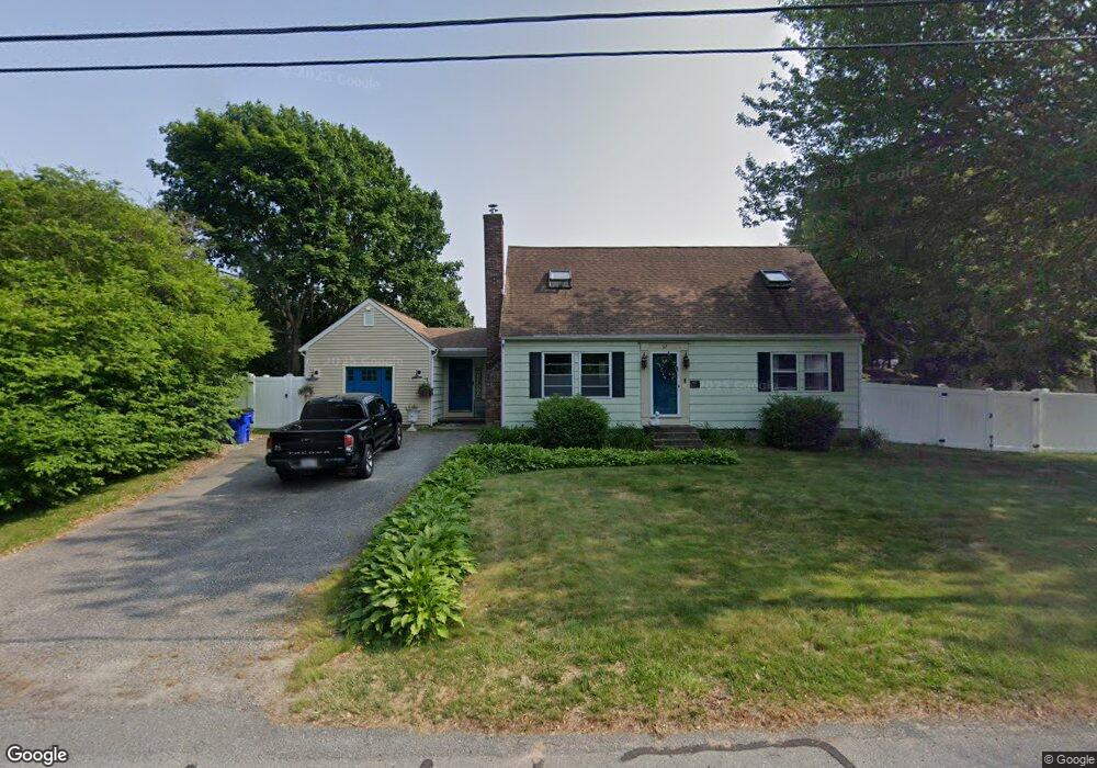
67 Sachem Dr Sagamore Beach, MA 02562
Estimated Value: $594,750 - $702,000
3
Beds
2
Baths
1,801
Sq Ft
$363/Sq Ft
Est. Value
About This Home
This home is located at 67 Sachem Dr, Sagamore Beach, MA 02562 and is currently estimated at $653,688, approximately $362 per square foot. 67 Sachem Dr is a home located in Barnstable County with nearby schools including Bourne High School, Bridgeview Montessori School, and Waldorf School of Cape Cod.
Ownership History
Date
Name
Owned For
Owner Type
Purchase Details
Closed on
Oct 18, 2004
Sold by
Mcginley Maria
Bought by
Pasierb Judith and Pasierb Peter J
Current Estimated Value
Home Financials for this Owner
Home Financials are based on the most recent Mortgage that was taken out on this home.
Original Mortgage
$120,000
Interest Rate
5.8%
Mortgage Type
Purchase Money Mortgage
Purchase Details
Closed on
Jun 28, 2002
Sold by
Giglio Peter M and Giglio Carol A
Bought by
Mcginley Maria
Home Financials for this Owner
Home Financials are based on the most recent Mortgage that was taken out on this home.
Original Mortgage
$187,500
Interest Rate
6.92%
Mortgage Type
Purchase Money Mortgage
Purchase Details
Closed on
Sep 29, 1995
Sold by
Broussard Arthur W and Broussard Mary P
Bought by
Giglio Peter M and Giglio Carol A
Create a Home Valuation Report for This Property
The Home Valuation Report is an in-depth analysis detailing your home's value as well as a comparison with similar homes in the area
Home Values in the Area
Average Home Value in this Area
Purchase History
| Date | Buyer | Sale Price | Title Company |
|---|---|---|---|
| Pasierb Judith | $334,000 | -- | |
| Pasierb Judith | $334,000 | -- | |
| Mcginley Maria | $250,000 | -- | |
| Mcginley Maria | $250,000 | -- | |
| Giglio Peter M | $160,000 | -- | |
| Giglio Peter M | $160,000 | -- |
Source: Public Records
Mortgage History
| Date | Status | Borrower | Loan Amount |
|---|---|---|---|
| Open | Giglio Peter M | $140,000 | |
| Closed | Pasierb Judith | $120,000 | |
| Previous Owner | Giglio Peter M | $187,500 |
Source: Public Records
Tax History Compared to Growth
Tax History
| Year | Tax Paid | Tax Assessment Tax Assessment Total Assessment is a certain percentage of the fair market value that is determined by local assessors to be the total taxable value of land and additions on the property. | Land | Improvement |
|---|---|---|---|---|
| 2025 | $4,235 | $542,200 | $195,600 | $346,600 |
| 2024 | $4,141 | $516,300 | $186,300 | $330,000 |
| 2023 | $4,025 | $456,900 | $164,800 | $292,100 |
| 2022 | $3,813 | $377,900 | $145,900 | $232,000 |
| 2021 | $3,706 | $344,100 | $132,800 | $211,300 |
| 2020 | $3,524 | $328,100 | $131,500 | $196,600 |
| 2019 | $3,333 | $317,100 | $131,500 | $185,600 |
| 2018 | $3,207 | $304,300 | $125,300 | $179,000 |
| 2017 | $3,103 | $301,300 | $124,100 | $177,200 |
| 2016 | $2,977 | $293,000 | $124,100 | $168,900 |
| 2015 | $2,837 | $281,700 | $112,800 | $168,900 |
Source: Public Records
Map
Nearby Homes
- 4 Fieldwood Dr
- 18 Ocean Pines Dr Unit A
- 133 Phillips Rd
- 51 Commonwealth Ave
- 51 Commonwealth Ave
- 67 Phillips Rd
- 67 Phillips Rd
- 33 Buzzards Bay Ave
- 10 Tecumseh Rd
- 311 Phillips Rd
- 0 State Rd
- 6 Louis Ave
- 15 Route 6a
- 20 Brady Rd
- 368 Old Plymouth Rd
- 5 Candlewood Dr
- 71 Tupper Rd
- 17 Ridgehill Ln
- 4 Bittersweet Ln Unit 4
- 11 Village Green Dr Unit B