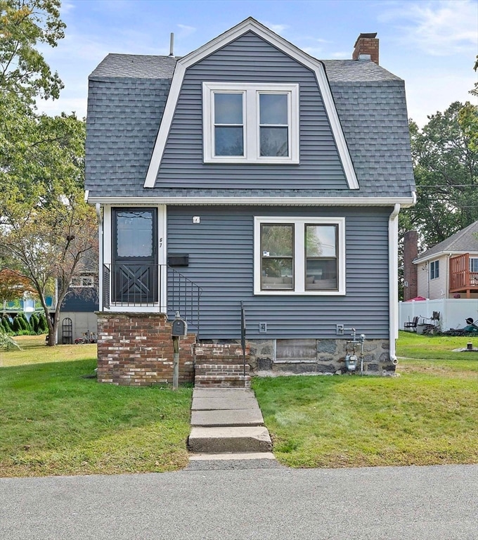


67 Somerville Ave Braintree, MA 02184
East Braintree NeighborhoodEstimated payment $3,049/month
Highlights
- Medical Services
- Deck
- Garrison Architecture
- Open Floorplan
- Property is near public transit
- No HOA
About This Home
OPEN HOUSE SUNDAY 11/9 11-1230! New Price! Don't miss this turn key home! Welcome to Braintree, a delightful single-family home that blends timeless New England character with modern convenience. Built in 1904, this residence features 2 bedrooms, a first-floor laundry room, and thoughtful updates throughout.Step into the inviting living room, with a warm and welcoming atmosphere—perfect for relaxing or entertaining. The kitchen offers ample workspace, making it both functional and beautiful for everyday cooking.Additional highlights include a back deck ideal for outdoor enjoyment, a new roof, and updated gas heating for comfort and efficiency. Located on a dead-end street, this property offers a wonderful setting while still being close to all that Braintree has to offer.Don’t miss the chance to make this charming home your own. Best turn key condo alternative. Reach out for a private showing! Great level yard, close to everything, dead end street & so much more.
Home Details
Home Type
- Single Family
Est. Annual Taxes
- $5,346
Year Built
- Built in 1904
Lot Details
- 9,601 Sq Ft Lot
- Property fronts a private road
- Level Lot
Home Design
- Garrison Architecture
- Stone Foundation
- Frame Construction
- Shingle Roof
Interior Spaces
- 942 Sq Ft Home
- Open Floorplan
- Ceiling Fan
- Dining Room with Fireplace
- Unfinished Basement
- Basement Fills Entire Space Under The House
Kitchen
- Range
- Microwave
Flooring
- Wall to Wall Carpet
- Laminate
- Vinyl
Bedrooms and Bathrooms
- 2 Bedrooms
- Primary bedroom located on second floor
- 1 Full Bathroom
Laundry
- Laundry Room
- Laundry on main level
- Washer and Gas Dryer Hookup
Parking
- 2 Car Parking Spaces
- Off-Street Parking
Outdoor Features
- Balcony
- Deck
Location
- Property is near public transit
- Property is near schools
Schools
- Morrison Elementary School
- East Middle School
- BHS High School
Utilities
- No Cooling
- Forced Air Heating System
- 1 Heating Zone
- Heating System Uses Natural Gas
- 100 Amp Service
- Gas Water Heater
Listing and Financial Details
- Assessor Parcel Number M:3053 B:0 L:27,23433
Community Details
Overview
- No Home Owners Association
Amenities
- Medical Services
- Shops
- Coin Laundry
Recreation
- Park
- Jogging Path
Map
Home Values in the Area
Average Home Value in this Area
Tax History
| Year | Tax Paid | Tax Assessment Tax Assessment Total Assessment is a certain percentage of the fair market value that is determined by local assessors to be the total taxable value of land and additions on the property. | Land | Improvement |
|---|---|---|---|---|
| 2025 | $5,346 | $535,700 | $348,500 | $187,200 |
| 2024 | $4,820 | $508,400 | $325,000 | $183,400 |
| 2023 | $4,542 | $465,400 | $292,000 | $173,400 |
| 2022 | $4,350 | $437,200 | $263,800 | $173,400 |
| 2021 | $3,996 | $401,600 | $238,300 | $163,300 |
| 2020 | $3,678 | $373,000 | $216,700 | $156,300 |
| 2019 | $3,558 | $352,600 | $207,200 | $145,400 |
| 2018 | $3,454 | $327,700 | $188,400 | $139,300 |
| 2017 | $3,333 | $310,300 | $179,000 | $131,300 |
| 2016 | $3,037 | $276,600 | $150,700 | $125,900 |
| 2015 | $2,720 | $245,700 | $148,800 | $96,900 |
| 2014 | $2,572 | $225,200 | $135,600 | $89,600 |
Property History
| Date | Event | Price | List to Sale | Price per Sq Ft |
|---|---|---|---|---|
| 11/07/2025 11/07/25 | Price Changed | $494,900 | -1.0% | $525 / Sq Ft |
| 10/20/2025 10/20/25 | For Sale | $499,900 | 0.0% | $531 / Sq Ft |
| 10/08/2025 10/08/25 | Pending | -- | -- | -- |
| 10/07/2025 10/07/25 | For Sale | $499,900 | 0.0% | $531 / Sq Ft |
| 10/03/2025 10/03/25 | Pending | -- | -- | -- |
| 09/24/2025 09/24/25 | For Sale | $499,900 | -- | $531 / Sq Ft |
Purchase History
| Date | Type | Sale Price | Title Company |
|---|---|---|---|
| Deed | $239,000 | -- |
Mortgage History
| Date | Status | Loan Amount | Loan Type |
|---|---|---|---|
| Open | $167,300 | Purchase Money Mortgage |
Source: MLS Property Information Network (MLS PIN)
MLS Number: 73435452
APN: BRAI-003053-000000-000027
Disclaimer: Certain information contained herein is derived from information provided by parties other than Homes.com. All information provided is deemed reliable, but is not guaranteed to be accurate and should be independently verified.
![]() The property listing data and information, or the Images, set forth herein were provided to MLS Property Information Network, Inc. from third party sources, including sellers, lessors and public records, and were compiled by MLS Property Information Network, Inc. The property listing data and information, and the Images, are for the personal, non-commercial use of consumers having a good faith interest in purchasing or leasing listed properties of the type displayed to them and may not be used for any purpose other than to identify prospective properties which such consumers may have a good faith interest in purchasing or leasing. MLS Property Information Network, Inc. and its subscribers disclaim any and all representations and warranties as to the accuracy of the property listing data and information, or as to the accuracy of any of the Images, set forth herein.
The property listing data and information, or the Images, set forth herein were provided to MLS Property Information Network, Inc. from third party sources, including sellers, lessors and public records, and were compiled by MLS Property Information Network, Inc. The property listing data and information, and the Images, are for the personal, non-commercial use of consumers having a good faith interest in purchasing or leasing listed properties of the type displayed to them and may not be used for any purpose other than to identify prospective properties which such consumers may have a good faith interest in purchasing or leasing. MLS Property Information Network, Inc. and its subscribers disclaim any and all representations and warranties as to the accuracy of the property listing data and information, or as to the accuracy of any of the Images, set forth herein.
- 312 Shaw St
- 83 Edgemont Rd
- 141 Hobart St
- 9 Hillside Ave
- 64 Arborway Dr
- 14 Howard Ct
- 60 Edgehill Rd
- 31 Tingley Rd
- 145 Commercial St Unit 3
- 69 Dobson Rd
- 141 Commercial St Unit 9
- 37 Skyline Dr Unit 11
- 21 Faxon St
- 685 Union St
- 51 Faxon St
- 25 W Howard St Unit D2
- 36 Brookside Rd
- 15 Bower Rd Unit A2
- 15 Bower Rd Unit B2
- 1 Pantano St
- 300 Quincy Ave Unit 2
- 32 Sheppard Ave Unit 32
- 30 Sheppard Ave Unit 30
- 79 Shaw
- 70 Front St Unit 2
- 50 Front St
- 287 Commercial St Unit 11
- 305 Commercial St Unit 305
- 100 Skyline Dr
- 323 Commercial St Unit 3
- 391 Commercial St
- 25 Commercial St
- 22 Washington St
- 488 Quincy Ave Unit 13
- 2 Mccusker Dr
- 10 Front St Unit 303
- 86 E Howard St Unit 104
- 139 Stetson St Unit 2
- 139-2 Stetson St Unit 2
- 71 Presidential Dr Unit 2
