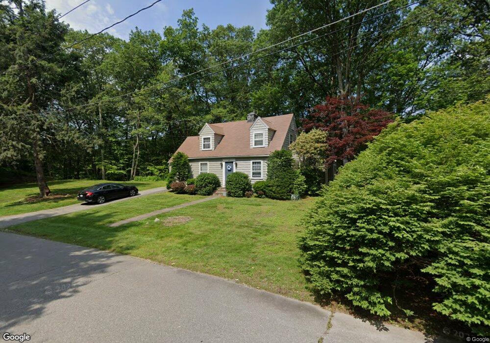
67 Sterling Rd Westwood, MA 02090
Estimated Value: $846,000 - $1,143,000
3
Beds
2
Baths
1,508
Sq Ft
$655/Sq Ft
Est. Value
About This Home
This home is located at 67 Sterling Rd, Westwood, MA 02090 and is currently estimated at $987,174, approximately $654 per square foot. 67 Sterling Rd is a home located in Norfolk County with nearby schools including Westwood High School, St Catherine Of Siena School, and Xaverian Brothers High School.
Ownership History
Date
Name
Owned For
Owner Type
Purchase Details
Closed on
Jun 29, 1998
Sold by
Disangro Joanne
Bought by
Blake Duane and Blake Jacqueline E
Current Estimated Value
Home Financials for this Owner
Home Financials are based on the most recent Mortgage that was taken out on this home.
Original Mortgage
$297,350
Interest Rate
7.09%
Mortgage Type
Purchase Money Mortgage
Purchase Details
Closed on
Apr 10, 1997
Sold by
Usa Ir
Bought by
Disangro Joanne
Create a Home Valuation Report for This Property
The Home Valuation Report is an in-depth analysis detailing your home's value as well as a comparison with similar homes in the area
Home Values in the Area
Average Home Value in this Area
Purchase History
| Date | Buyer | Sale Price | Title Company |
|---|---|---|---|
| Blake Duane | $313,000 | -- | |
| Disangro Joanne | $152,700 | -- |
Source: Public Records
Mortgage History
| Date | Status | Borrower | Loan Amount |
|---|---|---|---|
| Open | Disangro Joanne | $328,733 | |
| Closed | Disangro Joanne | $80,000 | |
| Closed | Disangro Joanne | $297,350 |
Source: Public Records
Tax History Compared to Growth
Tax History
| Year | Tax Paid | Tax Assessment Tax Assessment Total Assessment is a certain percentage of the fair market value that is determined by local assessors to be the total taxable value of land and additions on the property. | Land | Improvement |
|---|---|---|---|---|
| 2025 | $9,848 | $768,800 | $486,600 | $282,200 |
| 2024 | $9,848 | $768,800 | $486,600 | $282,200 |
| 2023 | $8,825 | $617,100 | $405,600 | $211,500 |
| 2022 | $8,221 | $554,350 | $342,900 | $211,450 |
| 2021 | $8,318 | $562,800 | $326,600 | $236,200 |
| 2020 | $7,864 | $542,000 | $326,600 | $215,400 |
| 2019 | $7,628 | $520,650 | $311,100 | $209,550 |
| 2018 | $7,313 | $484,600 | $311,100 | $173,500 |
| 2017 | $7,046 | $483,600 | $311,100 | $172,500 |
| 2016 | $6,972 | $475,550 | $311,100 | $164,450 |
| 2015 | $7,118 | $467,050 | $311,100 | $155,950 |
Source: Public Records
Map
Nearby Homes
- 4 Shoestring Ln
- 60 Warwick Dr
- 49 Fisher St
- 20 Lakeshore Dr
- 36 Kingswood Rd
- 18 Longmeadow Dr
- 20 Longmeadow Dr
- 48 Lakeshore Dr
- 401 Sandy Valley Rd
- 26 Longmeadow Dr
- 300 Nahatan St
- 314 Grove St
- 131 Bay Colony Dr
- 140 Burgess Ave
- 95 Arcadia Rd
- 17 Royal Ct
- 618 Nahatan St
- 300 Summer St
- 49 Powisset St
- 15 Wilsondale St
- 53 Sterling Rd
- 68 Sterling Rd
- 74 Sterling Rd
- 60 Sterling Rd
- 82 Sterling Rd
- 183 High Rock St
- 43 Sterling Rd
- 46 Sterling Rd
- 191 High Rock St
- 37 Sterling Rd
- 9 Westchester Dr
- 83 Oxford Rd
- 10 Westchester Dr
- 184 High Rock St
- 73 Oxford Rd
- 91 Oxford Rd
- 14 Salisbury Dr
- 63 Oxford Rd
- 192 High Rock St
- 36 Sterling Rd