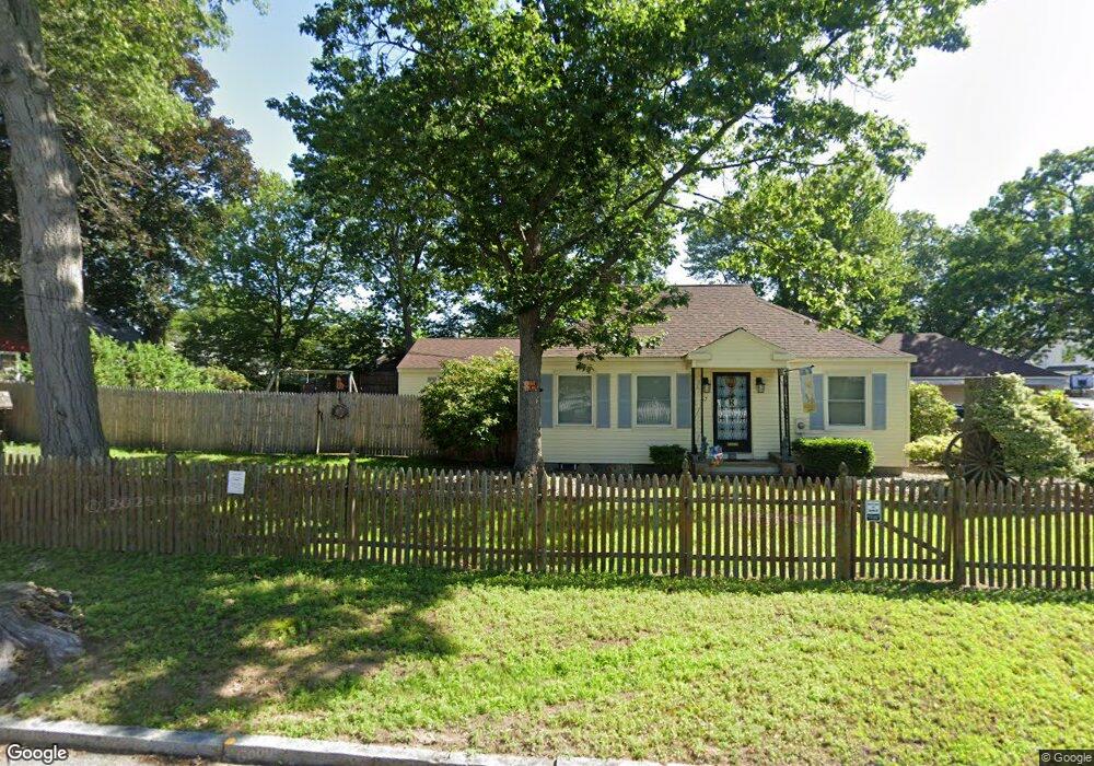
67 Superior Ave Indian Orchard, MA 01151
Estimated Value: $305,000 - $353,000
4
Beds
2
Baths
1,854
Sq Ft
$184/Sq Ft
Est. Value
About This Home
This home is located at 67 Superior Ave, Indian Orchard, MA 01151 and is currently estimated at $340,230, approximately $183 per square foot. 67 Superior Ave is a home located in Hampden County with nearby schools including Hiram L. Dorman Elementary, John F. Kennedy Academy, and Springfield Central High School.
Ownership History
Date
Name
Owned For
Owner Type
Purchase Details
Closed on
Aug 8, 1997
Sold by
Boulrice Rene A
Bought by
Rose Caleb E and Rose Sheila A
Current Estimated Value
Home Financials for this Owner
Home Financials are based on the most recent Mortgage that was taken out on this home.
Original Mortgage
$117,411
Outstanding Balance
$17,537
Interest Rate
7.5%
Mortgage Type
Purchase Money Mortgage
Estimated Equity
$322,693
Create a Home Valuation Report for This Property
The Home Valuation Report is an in-depth analysis detailing your home's value as well as a comparison with similar homes in the area
Home Values in the Area
Average Home Value in this Area
Purchase History
| Date | Buyer | Sale Price | Title Company |
|---|---|---|---|
| Rose Caleb E | $119,900 | -- |
Source: Public Records
Mortgage History
| Date | Status | Borrower | Loan Amount |
|---|---|---|---|
| Open | Rose Caleb E | $117,411 |
Source: Public Records
Tax History Compared to Growth
Tax History
| Year | Tax Paid | Tax Assessment Tax Assessment Total Assessment is a certain percentage of the fair market value that is determined by local assessors to be the total taxable value of land and additions on the property. | Land | Improvement |
|---|---|---|---|---|
| 2025 | $4,646 | $296,300 | $47,800 | $248,500 |
| 2024 | $4,596 | $286,200 | $44,700 | $241,500 |
| 2023 | $4,126 | $242,000 | $36,700 | $205,300 |
| 2022 | $3,709 | $197,100 | $34,200 | $162,900 |
| 2021 | $3,487 | $184,500 | $31,100 | $153,400 |
| 2020 | $3,535 | $181,000 | $31,100 | $149,900 |
| 2019 | $3,206 | $162,900 | $32,200 | $130,700 |
| 2018 | $3,121 | $158,600 | $32,200 | $126,400 |
| 2017 | $3,114 | $158,400 | $27,400 | $131,000 |
| 2016 | $2,933 | $149,200 | $27,400 | $121,800 |
| 2015 | $2,943 | $149,600 | $27,400 | $122,200 |
Source: Public Records
Map
Nearby Homes
- 77 Superior Ave
- 68 Lorimer St
- 74 Lorimer St
- 62 Lorimer St
- 57 Superior Ave
- 0 Superior Ave (Ns) Unit 72476315
- 58 Lorimer St
- 78 Lorimer St
- 64 Superior Ave
- 0 Superior Ave
- 83 Superior Ave
- 78 Superior Ave
- 54 Lorimer St
- 84 Lorimer St
- 60 Superior Ave
- 49 Superior Ave
- 82 Superior Ave
- 87 Superior Ave
- 83 Superior Ave (Ns)
- 88 Lorimer St