Estimated Value: $41,000 - $60,000
3
Beds
2
Baths
1,766
Sq Ft
$31/Sq Ft
Est. Value
About This Home
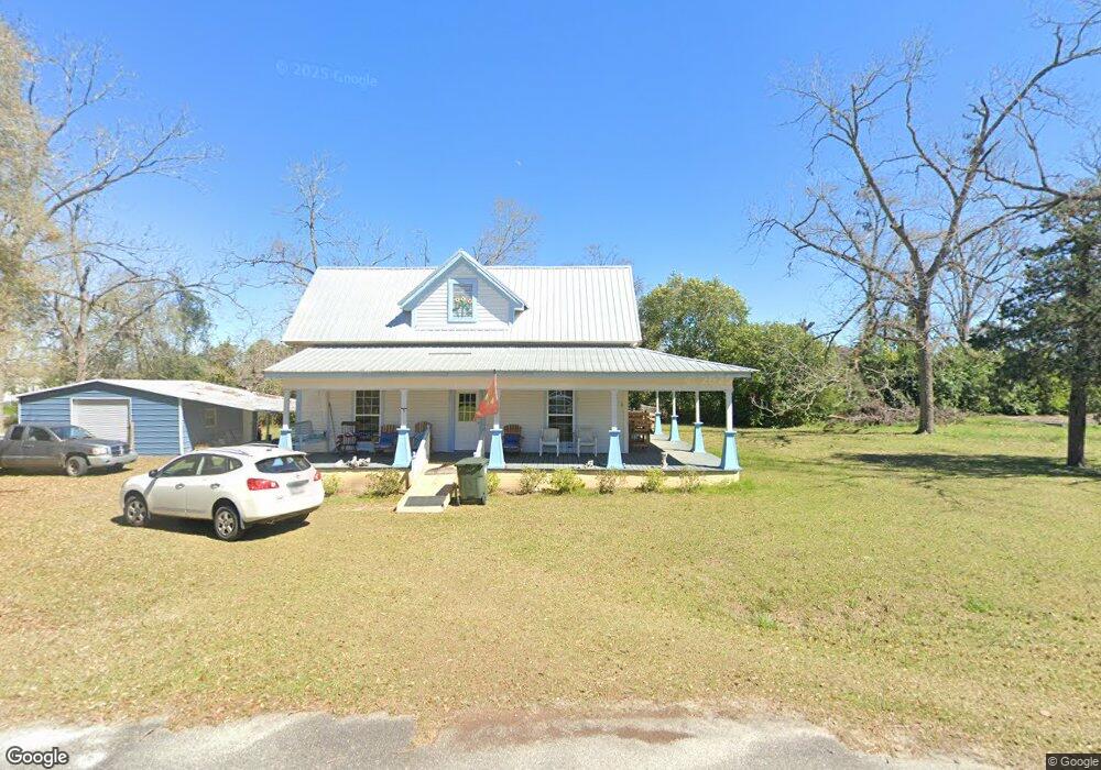
This home is located at 67 Union St, Cecil, GA 31627 and is currently estimated at $54,741, approximately $30 per square foot. 67 Union St is a home located in Cook County with nearby schools including Cook Primary School, Cook Elementary School, and Cook County Middle School.
Ownership History
Date
Name
Owned For
Owner Type
Purchase Details
Closed on
Jun 28, 2024
Sold by
Danberger Fieldene L
Bought by
Roberts Dale P and Roberts Ronda J
Current Estimated Value
Purchase Details
Closed on
Oct 21, 2015
Sold by
Danberger Fieldene
Bought by
Danberger Fieldene and Poe Katrina M
Purchase Details
Closed on
Jun 2, 2015
Sold by
Fulghum Kimberly L
Bought by
Synovus Bank
Purchase Details
Closed on
Aug 28, 2008
Sold by
Federal National Mortgage Association
Bought by
Fulghum Kimberly
Purchase Details
Closed on
Oct 2, 2007
Sold by
Hockman Dianna M
Bought by
Federal National Mtg Associati
Create a Home Valuation Report for This Property
The Home Valuation Report is an in-depth analysis detailing your home's value as well as a comparison with similar homes in the area
Home Values in the Area
Average Home Value in this Area
Purchase History
| Date | Buyer | Sale Price | Title Company |
|---|---|---|---|
| Roberts Dale P | $40,000 | -- | |
| Danberger Fieldene | -- | -- | |
| Danberger Fieldene | $20,000 | -- | |
| Synovus Bank | $30,000 | -- | |
| Fulghum Kimberly | $48,000 | -- | |
| Federal National Mtg Associati | $96,151 | -- |
Source: Public Records
Tax History Compared to Growth
Tax History
| Year | Tax Paid | Tax Assessment Tax Assessment Total Assessment is a certain percentage of the fair market value that is determined by local assessors to be the total taxable value of land and additions on the property. | Land | Improvement |
|---|---|---|---|---|
| 2024 | $944 | $26,059 | $2,833 | $23,226 |
| 2023 | $89 | $23,299 | $2,530 | $20,769 |
| 2022 | $574 | $23,299 | $2,530 | $20,769 |
| 2021 | $537 | $20,534 | $2,530 | $18,004 |
| 2020 | $537 | $20,534 | $2,530 | $18,004 |
| 2019 | $538 | $20,534 | $2,530 | $18,004 |
| 2018 | $859 | $20,534 | $2,530 | $18,004 |
| 2017 | $429 | $16,757 | $2,530 | $14,227 |
| 2016 | $176 | $36,972 | $2,530 | $34,442 |
| 2015 | $1,017 | $36,971 | $2,530 | $34,442 |
| 2014 | $1,018 | $36,971 | $2,530 | $34,442 |
| 2013 | -- | $36,971 | $2,529 | $34,441 |
Source: Public Records
Map
Nearby Homes
- 66 Hinson St
- 1864 Caulie Harris Rd
- 7909 Webb Rd N
- 8009 Webb Rd N
- 331 Barry Field Cir
- 335 Barry Field Cir
- 355 Barry Field Cir
- 343 Barry Field Cir
- 339 Barry Field Cir
- 347 Barry Field Cir
- 107 Floyd McNeal Dr
- 117 Floyd McNeal Dr
- 374 Barry Field Cir
- 186 Jefferson Rd
- 168 Floyd McNeal Dr
- 351 Barry Field Cir
- 169 Audrey Ln
- 228 Barry Field Cir
- 7305 Wind Chase Dr
- 7250 Tillman Branch Rd
- 14 Main St
- 84 Williams St
- 70 Union St
- 126 Railroad St
- 26 Union St
- 115 Union St
- 84 Williams St
- 107 Williams St
- 107 William Browning Rd
- 507 Railroad St
- 112 Union St
- 204 W Roundtree St
- 45 North St
- 405 Railroad St
- 77 E Roundtree St
- 108 Rountree Ln
- 176 Railroad St
- 1350 Highway 41
- 257 Williams St
- 706 N Street Cecil