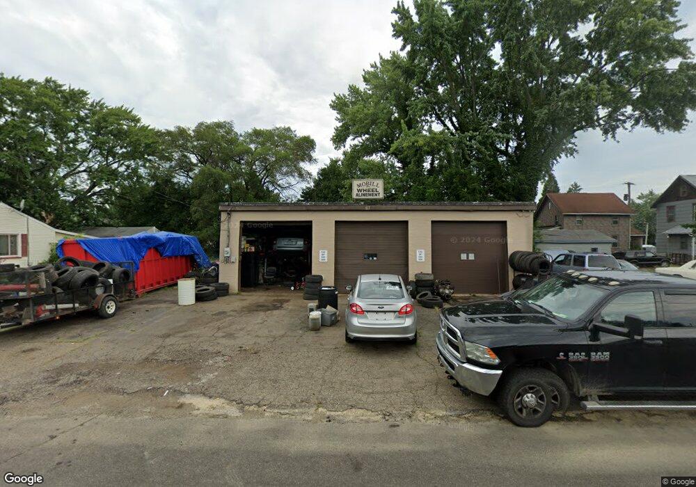
67 W Perry St Alliance, OH 44601
Studio
1
Bath
1,600
Sq Ft
11,326
Sq Ft Lot
About This Home
This home is located at 67 W Perry St, Alliance, OH 44601. 67 W Perry St is a home located in Stark County with nearby schools including Alliance Early Learning School, Alliance Intermediate School at Northside, and Alliance Middle School.
Ownership History
Date
Name
Owned For
Owner Type
Purchase Details
Closed on
May 18, 2020
Sold by
Title Store Ltd
Bought by
Lmt Properties Ii Llc
Purchase Details
Closed on
Apr 30, 2018
Sold by
Nobil Wheel Alignment Llc
Bought by
Lab Steven M and The Steven M Lab Irrevocable Trust
Purchase Details
Closed on
May 10, 2013
Sold by
Lab Steven M and Lab Dennis S
Bought by
Mobill Wheel Alignment Llc
Purchase Details
Closed on
Aug 21, 1990
Create a Home Valuation Report for This Property
The Home Valuation Report is an in-depth analysis detailing your home's value as well as a comparison with similar homes in the area
Home Values in the Area
Average Home Value in this Area
Purchase History
| Date | Buyer | Sale Price | Title Company |
|---|---|---|---|
| Lmt Properties Ii Llc | -- | Heritage Union Title Co Ltd | |
| Lab Steven M | -- | None Available | |
| Mobill Wheel Alignment Llc | -- | None Available | |
| -- | $30,000 | -- |
Source: Public Records
Tax History
| Year | Tax Paid | Tax Assessment Tax Assessment Total Assessment is a certain percentage of the fair market value that is determined by local assessors to be the total taxable value of land and additions on the property. | Land | Improvement |
|---|---|---|---|---|
| 2025 | -- | $15,890 | $4,410 | $11,480 |
| 2024 | -- | $15,890 | $4,410 | $11,480 |
| 2023 | $640 | $12,080 | $4,550 | $7,530 |
| 2022 | $646 | $12,080 | $4,550 | $7,530 |
| 2021 | $643 | $12,080 | $4,550 | $7,530 |
| 2020 | $630 | $10,960 | $4,130 | $6,830 |
| 2019 | $614 | $10,960 | $4,130 | $6,830 |
Source: Public Records
Map
Nearby Homes
- 717 Garfield Ave
- 505 N Union Ave
- 710 N Freedom Ave
- 11344 Walnut Ave NE
- 171 1/2 W Main St
- 163 W Market St
- 62 E Market St
- 000 Meadowbrook Ave
- 0 Meadowbrook Ave
- 264 W Market St
- 361 E Main St
- 118 S Mckinley Ave
- 15832 Waverly St NE
- 11335 Meadowbrook Ave NE
- 0 Homestead Ave NE
- 62 E High St
- 550 Johnson Ave
- 432 Johnson Ave
- 427 S Union Ave
- 847 E Patterson St
Your Personal Tour Guide
Ask me questions while you tour the home.