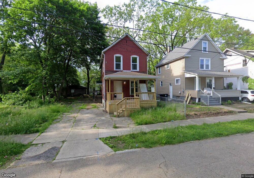
670 Bellevue Ave Akron, OH 44307
Sherbondy Hill NeighborhoodEstimated Value: $65,684 - $85,000
3
Beds
1
Bath
1,280
Sq Ft
$58/Sq Ft
Est. Value
About This Home
This home is located at 670 Bellevue Ave, Akron, OH 44307 and is currently estimated at $73,671, approximately $57 per square foot. 670 Bellevue Ave is a home located in Summit County with nearby schools including St. Bernard-St. Mary Elementary School.
Ownership History
Date
Name
Owned For
Owner Type
Purchase Details
Closed on
Aug 3, 2023
Sold by
Crumbley James
Bought by
Anderson Weslynn Kamore
Current Estimated Value
Purchase Details
Closed on
Jul 10, 2023
Sold by
Crumbley James
Bought by
Anderson Weslynn Kamore
Purchase Details
Closed on
Sep 22, 2022
Sold by
Tees Services
Bought by
Crumbley James
Purchase Details
Closed on
Feb 4, 2013
Sold by
Bable Johnny C
Bought by
Tees Services
Purchase Details
Closed on
Feb 1, 2013
Sold by
Bable Johnny C
Bought by
Tees Services
Create a Home Valuation Report for This Property
The Home Valuation Report is an in-depth analysis detailing your home's value as well as a comparison with similar homes in the area
Home Values in the Area
Average Home Value in this Area
Purchase History
| Date | Buyer | Sale Price | Title Company |
|---|---|---|---|
| Anderson Weslynn Kamore | $35,130 | None Listed On Document | |
| Anderson Weslynn Kamore | $35,130 | None Listed On Document | |
| Crumbley James | -- | -- | |
| Tees Services | $7,520 | None Available | |
| Tees Services | $7,520 | None Available |
Source: Public Records
Tax History Compared to Growth
Tax History
| Year | Tax Paid | Tax Assessment Tax Assessment Total Assessment is a certain percentage of the fair market value that is determined by local assessors to be the total taxable value of land and additions on the property. | Land | Improvement |
|---|---|---|---|---|
| 2025 | $4,333 | $12,296 | $3,413 | $8,883 |
| 2024 | $714 | $12,296 | $3,413 | $8,883 |
| 2023 | $4,333 | $12,296 | $3,413 | $8,883 |
| 2022 | $569 | $7,235 | $2,009 | $5,226 |
| 2021 | $570 | $7,235 | $2,009 | $5,226 |
| 2020 | $562 | $7,240 | $2,010 | $5,230 |
| 2019 | $664 | $7,980 | $2,340 | $5,640 |
| 2018 | $656 | $7,980 | $2,340 | $5,640 |
| 2017 | $744 | $7,980 | $2,340 | $5,640 |
| 2016 | $744 | $8,130 | $2,340 | $5,790 |
| 2015 | $744 | $8,130 | $2,340 | $5,790 |
| 2014 | $739 | $8,130 | $2,340 | $5,790 |
| 2013 | $710 | $8,130 | $2,340 | $5,790 |
Source: Public Records
Map
Nearby Homes
- 639 Bellevue Ave
- 650 Easter Ave
- 670 Euclid Ave
- 677 Vernon Odom Blvd
- 737 Vernon Odom Blvd
- 817 Raymond St
- 776 Krause Ct
- 985 Diana Ave
- 1132 Bristol Terrace
- 853 Fried St
- 385 Campbell St
- 861 Glenn St
- 949 Raymond St
- 881 Stoner St
- 577 Rhodes Ave
- 614 East Ave
- 644 Diagonal Rd
- 1206 Diagonal Rd
- VL Mercer Ave
- 605 East Ave
- 674 Bellevue Ave
- 678 Bellevue Ave
- 667 Dorothy Ave
- 671 Dorothy Ave
- 656 Bellevue Ave
- 0 Bellevue Ave Unit 3118658
- 667 Bellevue Ave
- 907 East Ave
- 663 Bellevue Ave
- 675 Dorothy Ave
- 661 Bellevue Ave
- 655 Dorothy Ave
- 652 Bellevue Ave
- 655 Bellevue Ave
- 651 Dorothy Ave
- 919 East Ave
- 887 East Ave
- 651 Bellevue Ave
- 647 Dorothy Ave
- 778 Ruth Ave