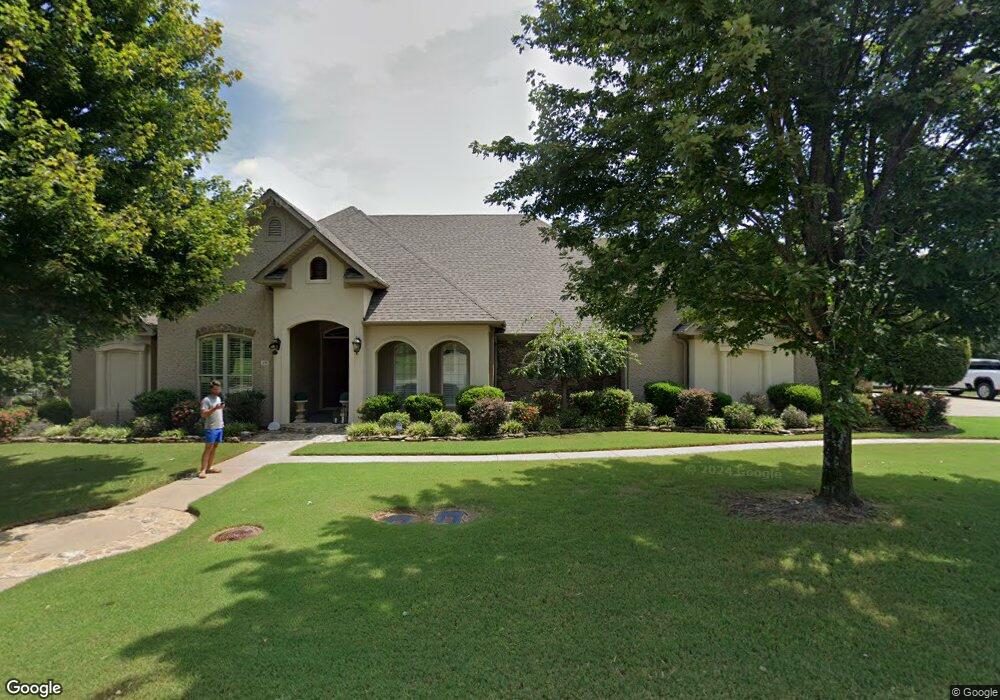
670 Huntington Ln Conway, AR 72034
Estimated Value: $674,000 - $737,009
--
Bed
4
Baths
3,829
Sq Ft
$184/Sq Ft
Est. Value
About This Home
This home is located at 670 Huntington Ln, Conway, AR 72034 and is currently estimated at $705,502, approximately $184 per square foot. 670 Huntington Ln is a home located in Faulkner County with nearby schools including Woodrow Cummins Elementary School, Ruth Doyle Intermediate School, and Conway Junior High School.
Ownership History
Date
Name
Owned For
Owner Type
Purchase Details
Closed on
Jul 22, 2025
Sold by
Patricia And Terrance Sossong Revocable and Sossong Patricia Anne
Bought by
Richard And Deann Graham Joint Revocable Trus and Graham
Current Estimated Value
Purchase Details
Closed on
Jul 30, 2021
Sold by
Sossong Terrance P and Sossong Patricia A
Bought by
Sossong Patricia Anne and Sossong Philip Terrance
Purchase Details
Closed on
Sep 21, 2020
Sold by
Price C Roger C and Price Kay S
Bought by
Sossong Terrance P and Sossong Patricia A
Home Financials for this Owner
Home Financials are based on the most recent Mortgage that was taken out on this home.
Original Mortgage
$314,000
Interest Rate
2.9%
Mortgage Type
New Conventional
Purchase Details
Closed on
Apr 4, 2008
Bought by
Price Trust
Purchase Details
Closed on
Mar 31, 2008
Bought by
Watson Hms
Create a Home Valuation Report for This Property
The Home Valuation Report is an in-depth analysis detailing your home's value as well as a comparison with similar homes in the area
Home Values in the Area
Average Home Value in this Area
Purchase History
| Date | Buyer | Sale Price | Title Company |
|---|---|---|---|
| Richard And Deann Graham Joint Revocable Trus | $675,000 | Waco Title | |
| Sossong Patricia Anne | -- | None Available | |
| Sossong Terrance P | $559,000 | Lenders Title Company | |
| Price Trust | $85,000 | -- | |
| Price C Roger | $78,939 | None Available | |
| Watson Hms | $133,000 | -- |
Source: Public Records
Mortgage History
| Date | Status | Borrower | Loan Amount |
|---|---|---|---|
| Previous Owner | Sossong Terrance P | $314,000 |
Source: Public Records
Tax History Compared to Growth
Tax History
| Year | Tax Paid | Tax Assessment Tax Assessment Total Assessment is a certain percentage of the fair market value that is determined by local assessors to be the total taxable value of land and additions on the property. | Land | Improvement |
|---|---|---|---|---|
| 2025 | $5,394 | $128,760 | $18,000 | $110,760 |
| 2024 | $5,394 | $128,760 | $18,000 | $110,760 |
| 2023 | $5,394 | $106,600 | $18,000 | $88,600 |
| 2022 | $5,019 | $106,600 | $18,000 | $88,600 |
| 2021 | $5,019 | $106,600 | $18,000 | $88,600 |
| 2020 | $4,061 | $92,780 | $18,000 | $74,780 |
| 2019 | $4,061 | $92,780 | $18,000 | $74,780 |
| 2018 | $4,086 | $92,780 | $18,000 | $74,780 |
| 2017 | $4,086 | $92,780 | $18,000 | $74,780 |
| 2016 | $4,086 | $87,660 | $18,000 | $69,660 |
| 2015 | $4,436 | $92,390 | $18,000 | $74,390 |
| 2014 | $4,086 | $92,390 | $18,000 | $74,390 |
Source: Public Records
Map
Nearby Homes
- 760 Bristol Ln
- 345 Point Dr W
- 335 Vintage Cove
- 5430 Chateau Dr
- 5120 Trinity Crossing Dr
- 5005 Prestonwood Rd
- 1040 Calloway Dr
- 1060 Georgetown Dr
- 1105 Georgetown Dr
- 4830 Edgewood Park
- 5268 Prince St
- 980 Timber Knoll Dr
- 4805 Edgewood Park
- 4685 College Ave
- 150 Merlot Dr
- 5920 Brush Creek Loop
- 4640 Valiant Dr
- 4575 Prince St Lot 2ar
- 1360 Champions Dr
- 4640 Oregon Trail
- 664 Huntington Dr
- 700 Huntington Ln
- 0 Huntington Ln Unit 17034260
- 665 Huntington Ln
- 640 Huntington Ln
- 695 Huntington Ln
- 635 Huntington Ln
- 675 Bristol Ln
- 705 Bristol Ln
- 625 Bristol Ln
- 730 Huntington Ln
- 725 Huntington Ln
- 655 Bristol Ln
- 610 Huntington Ln
- 725 Bristol Ln
- 605 Huntington Ln
- 760 Huntington Ln
- 680 Bristol Ln
- 600 Bristol Ln
- 660 Bristol Ln