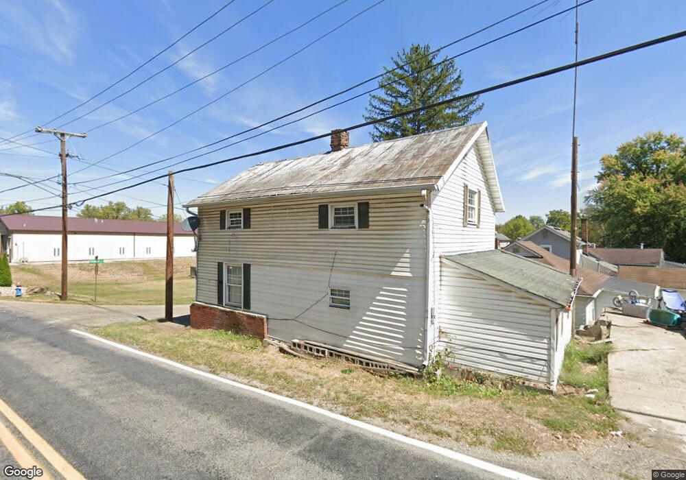
670 S Maple St Lancaster, OH 43130
Estimated Value: $97,427 - $181,000
2
Beds
1
Bath
892
Sq Ft
$154/Sq Ft
Est. Value
About This Home
This home is located at 670 S Maple St, Lancaster, OH 43130 and is currently estimated at $137,607, approximately $154 per square foot. 670 S Maple St is a home located in Fairfield County with nearby schools including Thomas Ewing Junior High School, Lancaster High School, and St Mary Elementary School.
Ownership History
Date
Name
Owned For
Owner Type
Purchase Details
Closed on
Oct 2, 2019
Sold by
Evans Randall L and Evans Christine A
Bought by
Rle Properties Llc
Current Estimated Value
Purchase Details
Closed on
Jun 7, 1996
Sold by
Shrf Beth Gatwood Pr
Bought by
Randy Evans
Home Financials for this Owner
Home Financials are based on the most recent Mortgage that was taken out on this home.
Original Mortgage
$38,000
Interest Rate
7.97%
Mortgage Type
New Conventional
Purchase Details
Closed on
Mar 14, 1994
Sold by
Wiseman Donald E
Bought by
Gatwood Beth Ann
Purchase Details
Closed on
Nov 21, 1991
Sold by
Mugg John W
Bought by
Wiseman Donald E
Create a Home Valuation Report for This Property
The Home Valuation Report is an in-depth analysis detailing your home's value as well as a comparison with similar homes in the area
Home Values in the Area
Average Home Value in this Area
Purchase History
| Date | Buyer | Sale Price | Title Company |
|---|---|---|---|
| Rle Properties Llc | -- | None Available | |
| Randy Evans | $30,000 | -- | |
| Gatwood Beth Ann | $34,500 | -- | |
| Wiseman Donald E | $13,800 | -- |
Source: Public Records
Mortgage History
| Date | Status | Borrower | Loan Amount |
|---|---|---|---|
| Previous Owner | Randy Evans | $38,000 |
Source: Public Records
Tax History Compared to Growth
Tax History
| Year | Tax Paid | Tax Assessment Tax Assessment Total Assessment is a certain percentage of the fair market value that is determined by local assessors to be the total taxable value of land and additions on the property. | Land | Improvement |
|---|---|---|---|---|
| 2024 | $1,313 | $14,600 | $2,510 | $12,090 |
| 2023 | $543 | $14,600 | $2,510 | $12,090 |
| 2022 | $546 | $14,600 | $2,510 | $12,090 |
| 2021 | $471 | $11,800 | $2,510 | $9,290 |
| 2020 | $280 | $11,800 | $2,510 | $9,290 |
| 2019 | $430 | $11,800 | $2,510 | $9,290 |
| 2018 | $318 | $13,820 | $2,510 | $11,310 |
| 2017 | $530 | $13,820 | $2,510 | $11,310 |
| 2016 | $517 | $13,820 | $2,510 | $11,310 |
| 2015 | $513 | $13,320 | $2,510 | $10,810 |
| 2014 | $490 | $13,320 | $2,510 | $10,810 |
| 2013 | $490 | $13,320 | $2,510 | $10,810 |
Source: Public Records
Map
Nearby Homes
- 1035 Sugar Grove Rd SE
- 1021 Sugar Grove Rd SE
- 441 E Locust St
- 308 Wheat St
- 571 E Chestnut St
- 545 E Main St
- 619 E Main St
- 534 E Wheeling St
- 233 Lewis Ave
- 629 E Wheeling St
- 154 E Main St
- 846 E Main St
- 608 E Mulberry St
- 1106 E Walnut St
- 844 E Wheeling St
- 0 N Columbus St
- 115 E Wheeling St
- 403 S Ewing St
- 641 King St
- 0 Hamburg Rd SW
- 504 Carpenter St
- 510 Carpenter St
- 680 S Maple St
- 675 S Maple St
- 675 S Maple St
- 665 S Maple St
- 501 Carpenter St
- 516 Carpenter St
- 661 S Maple St
- 683 S Maple St
- 515 Carpenter St
- 529 Carpenter St
- 523 Carpenter St
- 524 Carpenter St
- 687 S Maple St
- 530 Carpenter St
- 1236 Hornbeck Ave
- 693 S Maple St
- 533 Carpenter St
- 538 Carpenter St