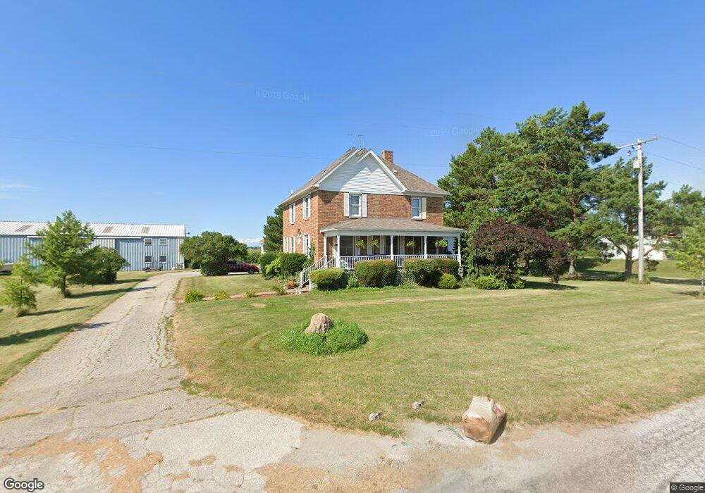
670 W Wilder Rd Auburn, MI 48611
Estimated Value: $269,000 - $301,377
3
Beds
1
Bath
2,240
Sq Ft
$130/Sq Ft
Est. Value
About This Home
This home is located at 670 W Wilder Rd, Auburn, MI 48611 and is currently estimated at $291,594, approximately $130 per square foot. 670 W Wilder Rd is a home located in Bay County with nearby schools including Auburn Elementary School, Western Middle School, and Bay City Western High School.
Ownership History
Date
Name
Owned For
Owner Type
Purchase Details
Closed on
Oct 1, 2020
Sold by
Rohde Michael J and Rohde Megan J
Bought by
Rohde Michael J and Rohde Megan J
Current Estimated Value
Purchase Details
Closed on
Sep 22, 2006
Sold by
King Clarence H and Pashak Connie J
Bought by
Rohde Michael J
Purchase Details
Closed on
Aug 10, 2005
Sold by
King Clarence H and King Casey N
Bought by
King Clarence H and Pashak Connie J
Home Financials for this Owner
Home Financials are based on the most recent Mortgage that was taken out on this home.
Original Mortgage
$159,350
Interest Rate
4.99%
Mortgage Type
Fannie Mae Freddie Mac
Purchase Details
Closed on
Feb 19, 2000
Sold by
King Clarence H
Bought by
King Clarence H and King Casey N
Create a Home Valuation Report for This Property
The Home Valuation Report is an in-depth analysis detailing your home's value as well as a comparison with similar homes in the area
Home Values in the Area
Average Home Value in this Area
Purchase History
| Date | Buyer | Sale Price | Title Company |
|---|---|---|---|
| Rohde Michael J | -- | None Available | |
| Rohde Michael J | $208,900 | None Available | |
| King Clarence H | -- | -- | |
| King Clarence H | -- | -- |
Source: Public Records
Mortgage History
| Date | Status | Borrower | Loan Amount |
|---|---|---|---|
| Previous Owner | King Clarence H | $159,350 |
Source: Public Records
Tax History Compared to Growth
Tax History
| Year | Tax Paid | Tax Assessment Tax Assessment Total Assessment is a certain percentage of the fair market value that is determined by local assessors to be the total taxable value of land and additions on the property. | Land | Improvement |
|---|---|---|---|---|
| 2025 | $3,474 | $133,250 | $0 | $0 |
| 2024 | $1,870 | $127,650 | $0 | $0 |
| 2023 | $1,780 | $114,500 | $0 | $0 |
| 2022 | $3,145 | $101,350 | $0 | $0 |
| 2021 | $2,918 | $95,400 | $0 | $95,400 |
| 2020 | $2,714 | $86,350 | $0 | $86,350 |
| 2019 | $2,614 | $73,050 | $0 | $0 |
| 2018 | $2,612 | $75,800 | $0 | $0 |
| 2017 | $2,488 | $72,900 | $0 | $0 |
| 2016 | $2,615 | $75,900 | $0 | $75,900 |
| 2015 | -- | $81,350 | $0 | $81,350 |
| 2014 | -- | $81,350 | $0 | $81,350 |
Source: Public Records
Map
Nearby Homes
- 0 W North Union Rd Unit 50166876
- 221 Sycamore Ln
- V/L N Garfield Rd
- 4649 Stephanie Ct
- 268 W Midland Rd
- 1365 W North Union Rd
- 0 Price St
- 230 W Midland Rd
- 4648 Meadow Ct
- 937 Appaloosa Pass
- 319 Price St
- 1186 W Midland Rd
- 4760 Putt Ln
- 423 Sunshine Ct
- 439 Wheeler Rd
- 1598 Fisherville Ct
- 1587 Fisherville Ct
- 4855 Wheat Ridge Ct
- 1598 Dawn Marie Ct
- 0 S Carter Unit 50178966
- 652 W Wilder Rd
- 636 W Wilder Rd
- 778 W Wilder Rd
- 834 W Wilder Rd
- 4040 S 9 Mile Rd
- 4088 S 9 Mile Rd
- 4049 S 9 Mile Rd
- 3909 S 9 Mile Rd
- 3856 S 9 Mile Rd
- 890 W Wilder Rd
- 3863 S 9 Mile Rd
- 4157 S 9 Mile Rd
- 3825 S 9 Mile Rd
- 3808 S 9 Mile Rd
- 3775 S 9 Mile Rd
- 4189 S 9 Mile Rd
- 4205 S 9 Mile Rd
- 3719 S 9 Mile Rd
- 4243 S 9 Mile Rd
- 3837 Garfield Rd