Estimated Value: $364,000 - $385,166
3
Beds
2
Baths
1,276
Sq Ft
$292/Sq Ft
Est. Value
About This Home
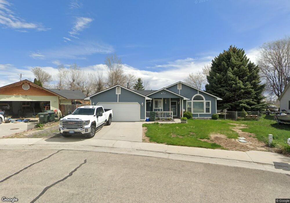
This home is located at 671 Blue Sky Dr, Kuna, ID 83634 and is currently estimated at $372,792, approximately $292 per square foot. 671 Blue Sky Dr is a home located in Ada County with nearby schools including Hubbard Elementary School, Ross Elementary School, and Fremont H. Teed Elementary School.
Ownership History
Date
Name
Owned For
Owner Type
Purchase Details
Closed on
Dec 30, 2024
Sold by
Robison Mark A
Bought by
Robison Mark A and Massey Vickie I
Current Estimated Value
Purchase Details
Closed on
May 20, 2002
Sold by
Robison Sharon K
Bought by
Robison Mark
Purchase Details
Closed on
Jul 21, 1999
Sold by
Hobson Barry L and Hobson Marnae
Bought by
Robison Mark A and Robison Sharon K
Home Financials for this Owner
Home Financials are based on the most recent Mortgage that was taken out on this home.
Original Mortgage
$99,000
Interest Rate
7.51%
Mortgage Type
VA
Create a Home Valuation Report for This Property
The Home Valuation Report is an in-depth analysis detailing your home's value as well as a comparison with similar homes in the area
Home Values in the Area
Average Home Value in this Area
Purchase History
| Date | Buyer | Sale Price | Title Company |
|---|---|---|---|
| Robison Mark A | -- | None Listed On Document | |
| Robison Mark | -- | -- | |
| Robison Mark A | -- | Transnation Title & Escrow I |
Source: Public Records
Mortgage History
| Date | Status | Borrower | Loan Amount |
|---|---|---|---|
| Previous Owner | Robison Mark A | $99,000 |
Source: Public Records
Tax History
| Year | Tax Paid | Tax Assessment Tax Assessment Total Assessment is a certain percentage of the fair market value that is determined by local assessors to be the total taxable value of land and additions on the property. | Land | Improvement |
|---|---|---|---|---|
| 2025 | $1,207 | $367,700 | -- | -- |
| 2024 | $1,199 | $373,400 | -- | -- |
| 2023 | $1,199 | $317,700 | $0 | $0 |
| 2022 | $1,515 | $370,700 | $0 | $0 |
| 2021 | $1,437 | $294,800 | $0 | $0 |
| 2020 | $1,287 | $218,400 | $0 | $0 |
| 2019 | $1,091 | $175,400 | $0 | $0 |
| 2018 | $996 | $147,500 | $0 | $0 |
| 2017 | $950 | $135,400 | $0 | $0 |
| 2016 | $899 | $125,200 | $0 | $0 |
| 2015 | $886 | $114,100 | $0 | $0 |
| 2012 | -- | $68,400 | $0 | $0 |
Source: Public Records
Map
Nearby Homes
- 367 E 3rd St
- 351 E 3rd St
- 390 N Cleveland Ave
- 222 E 2nd St
- 1172 E Cottage St
- 210 Morris Ct
- 974 E Odyssey St
- 980 E Odyssey St
- 1067 W Troy Place
- 1360 S Bobby Ave
- 1315 S Bobby Ave
- 173 W Rockaway Dr
- 1338 S Bobby Ave
- 1337 S Bobby Ave
- 0 Refer To "Exhibit A" Unit 98969866
- 1036 E Exploration Dr
- 1052 E Exploration Dr
- 1076 E Exploration Dr
- 1276 N Cambrick Dr
- 121 S Ziklag Ave
- 669 E 4th St
- 655 Blue Sky Dr
- 679 E 4th St
- 643 Blue Sky Dr
- 660 Blue Sky Dr
- 634 Blue Sky Dr
- 627 Blue Sky Dr
- 665 E Santolina St
- 683 E Santolina St
- 647 E Santolina St
- 598 Easy St
- 701 E Santolina St
- 580 Easy St
- 629 E Santolina St
- 717 E Santolina St
- 605 Blue Sky Dr
- 607 E Santolina St
- 735 E Santolina St
- 590 Blue Sky Dr
- 568 Easy St
Your Personal Tour Guide
Ask me questions while you tour the home.