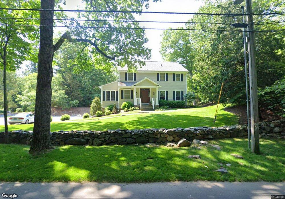
671 Cedar Rd Southport, CT 06890
Estimated Value: $1,805,912 - $2,221,000
4
Beds
4
Baths
2,938
Sq Ft
$661/Sq Ft
Est. Value
About This Home
This home is located at 671 Cedar Rd, Southport, CT 06890 and is currently estimated at $1,940,728, approximately $660 per square foot. 671 Cedar Rd is a home located in Fairfield County with nearby schools including Dwight Elementary School, Roger Ludlowe Middle School, and Fairfield Ludlowe High School.
Ownership History
Date
Name
Owned For
Owner Type
Purchase Details
Closed on
Sep 29, 2003
Sold by
Cacchione Robert E
Bought by
Lyons James F and Lyons Christine
Current Estimated Value
Purchase Details
Closed on
Nov 21, 2002
Sold by
Towler William H and Towler June P
Bought by
Cacchione Robert
Create a Home Valuation Report for This Property
The Home Valuation Report is an in-depth analysis detailing your home's value as well as a comparison with similar homes in the area
Home Values in the Area
Average Home Value in this Area
Purchase History
| Date | Buyer | Sale Price | Title Company |
|---|---|---|---|
| Lyons James F | $1,165,000 | -- | |
| Lyons James F | $1,165,000 | -- | |
| Cacchione Robert | $412,500 | -- | |
| Cacchione Robert | $412,500 | -- |
Source: Public Records
Mortgage History
| Date | Status | Borrower | Loan Amount |
|---|---|---|---|
| Open | Cacchione Robert | $623,341 | |
| Closed | Cacchione Robert | $705,000 | |
| Closed | Cacchione Robert | $708,750 |
Source: Public Records
Tax History Compared to Growth
Tax History
| Year | Tax Paid | Tax Assessment Tax Assessment Total Assessment is a certain percentage of the fair market value that is determined by local assessors to be the total taxable value of land and additions on the property. | Land | Improvement |
|---|---|---|---|---|
| 2025 | $21,749 | $766,080 | $466,550 | $299,530 |
| 2024 | $21,374 | $766,080 | $466,550 | $299,530 |
| 2023 | $21,075 | $766,080 | $466,550 | $299,530 |
| 2022 | $20,868 | $766,080 | $466,550 | $299,530 |
| 2021 | $20,669 | $766,080 | $466,550 | $299,530 |
| 2020 | $21,693 | $809,760 | $461,790 | $347,970 |
| 2019 | $21,693 | $809,760 | $461,790 | $347,970 |
| 2018 | $21,345 | $809,760 | $461,790 | $347,970 |
| 2017 | $20,908 | $809,760 | $461,790 | $347,970 |
| 2016 | $20,608 | $809,760 | $461,790 | $347,970 |
| 2015 | $20,075 | $809,802 | $434,112 | $375,690 |
| 2014 | $19,759 | $809,802 | $434,112 | $375,690 |
Source: Public Records
Map
Nearby Homes
- 1135 Mill Hill Rd
- 688 Hulls Farm Rd
- 1213 Cedar Rd
- 1001 Hulls Farm Rd
- 844 Mill Hill Terrace
- 476 Mill Hill Terrace
- 1 Sturges Hwy Unit Lot 1
- 1 Sturges Hwy Unit 2
- 153 Pease Ave
- 2683 Bronson Rd
- 10 Debra Ln
- 21 Queens Grant Dr
- 53 Hilltop Dr
- 125 Old Rd
- 647 Bronson Rd
- 254 Sherwood Farm Rd
- 107 Old Rd
- 1 Coastal Ct
- 28 Mill Hill Rd Unit 28
- 232 Pell Meadow Dr
- 88 Half Mile Rd
- 637 Cedar Rd
- 105 Sturbridge Ln
- 720 Cedar Rd
- 615 Cedar Rd
- 24 Half Mile Rd
- 100 Sturbridge Ln
- 777 Cedar Rd
- 583 Cedar Rd
- 141 Sturbridge Ln
- 85 Half Mile Ln
- 141 Half Mile Rd
- 140 Sturbridge Ln
- 805 Cedar Rd
- 174 Half Mile Rd
- 160 Sturbridge Ln
- 770 Cedar Rd
- 175 Sturbridge Ln
- 537 Cedar Rd
- 105 Half Mile Ln