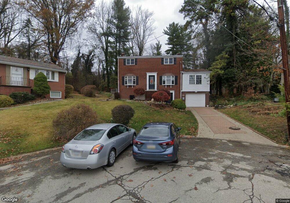
671 Debaldo Dr West Mifflin, PA 15122
Estimated Value: $264,000 - $278,000
4
Beds
2
Baths
1,924
Sq Ft
$141/Sq Ft
Est. Value
About This Home
This home is located at 671 Debaldo Dr, West Mifflin, PA 15122 and is currently estimated at $271,801, approximately $141 per square foot. 671 Debaldo Dr is a home located in Allegheny County with nearby schools including West Mifflin Area High School, Walnut Grove Christian School, and Cornerstone Leadership Academy.
Ownership History
Date
Name
Owned For
Owner Type
Purchase Details
Closed on
Feb 9, 2022
Sold by
Garofolo Anthony J and Garofolo Arlene L
Bought by
Ruffing Michael D and Ruffing Pamela C
Current Estimated Value
Home Financials for this Owner
Home Financials are based on the most recent Mortgage that was taken out on this home.
Original Mortgage
$220,400
Outstanding Balance
$204,683
Interest Rate
3.56%
Mortgage Type
New Conventional
Estimated Equity
$67,118
Purchase Details
Closed on
Feb 7, 2022
Sold by
Maszle Edward J and Maszle Arlene L
Bought by
Ruffing Michael D and Ruffing Pamela C
Home Financials for this Owner
Home Financials are based on the most recent Mortgage that was taken out on this home.
Original Mortgage
$220,400
Outstanding Balance
$204,683
Interest Rate
3.56%
Mortgage Type
New Conventional
Estimated Equity
$67,118
Purchase Details
Closed on
Jul 29, 1976
Bought by
Maszle Edward J and Maszle Arlene L
Create a Home Valuation Report for This Property
The Home Valuation Report is an in-depth analysis detailing your home's value as well as a comparison with similar homes in the area
Home Values in the Area
Average Home Value in this Area
Purchase History
| Date | Buyer | Sale Price | Title Company |
|---|---|---|---|
| Ruffing Michael D | $232,000 | -- | |
| Ruffing Michael D | $232,000 | -- | |
| Maszle Edward J | $45,000 | -- |
Source: Public Records
Mortgage History
| Date | Status | Borrower | Loan Amount |
|---|---|---|---|
| Open | Ruffing Michael D | $220,400 |
Source: Public Records
Tax History Compared to Growth
Tax History
| Year | Tax Paid | Tax Assessment Tax Assessment Total Assessment is a certain percentage of the fair market value that is determined by local assessors to be the total taxable value of land and additions on the property. | Land | Improvement |
|---|---|---|---|---|
| 2025 | $6,174 | $147,600 | $20,100 | $127,500 |
| 2024 | $6,174 | $147,600 | $20,100 | $127,500 |
| 2023 | $5,218 | $126,400 | $20,100 | $106,300 |
| 2022 | $4,982 | $108,400 | $20,100 | $88,300 |
| 2021 | $359 | $108,400 | $20,100 | $88,300 |
| 2020 | $4,795 | $108,400 | $20,100 | $88,300 |
| 2019 | $4,732 | $108,400 | $20,100 | $88,300 |
| 2018 | $359 | $108,400 | $20,100 | $88,300 |
| 2017 | $4,022 | $108,400 | $20,100 | $88,300 |
| 2016 | $513 | $108,400 | $20,100 | $88,300 |
| 2015 | $513 | $108,400 | $20,100 | $88,300 |
| 2014 | $3,987 | $108,400 | $20,100 | $88,300 |
Source: Public Records
Map
Nearby Homes
- 828 Alberta Dr
- 444 Spring Valley Rd
- 323 Livingston Rd
- 540 Lisa Dr
- 436 Lisa Dr
- 1157 Lebanon School Rd
- 109 Pennington Dr
- 0 Lebanon School Rd
- 1016 Dana Dr
- 1746 Gina Dr
- 1004 Kentucky Blue Dr
- 1717 Gina Dr
- 1864 Timothy Dr
- 3326 New England Rd
- 0 Clairton Rd
- 446 Lewis Run Rd
- 4009 Fleetwood Dr
- 453 Coal Valley Rd
- 1613 State Route 885
- 463 Coal Valley Rd
- 670 Debaldo Dr
- 663 Debaldo Dr
- 666 Debaldo Dr
- 662 Debaldo Dr
- 659 Debaldo Dr
- 733 Shadyside Dr
- 729 Shadyside Dr
- 737 Shadyside Dr
- 703 Saint Germaine Dr
- 655 Debaldo Dr
- 739 Shadyside Dr
- 725 Shadyside Dr
- 741 Shadyside Dr
- 721 Shadyside Dr
- 651 Debaldo Dr
- 650 Debaldo Dr
- 709 Saint Germaine Dr
- 717 Shadyside Dr
- 645 Debaldo Dr
- 736 Shadyside Dr