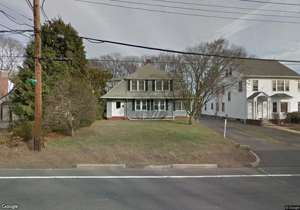
671 Forest Rd West Haven, CT 06516
Allingtown NeighborhoodEstimated Value: $338,000 - $432,000
3
Beds
1
Bath
1,705
Sq Ft
$221/Sq Ft
Est. Value
About This Home
This home is located at 671 Forest Rd, West Haven, CT 06516 and is currently estimated at $376,398, approximately $220 per square foot. 671 Forest Rd is a home located in New Haven County with nearby schools including Carrigan 5/6 Intermediate School, Harry M. Bailey Middle School, and West Haven High School.
Ownership History
Date
Name
Owned For
Owner Type
Purchase Details
Closed on
Apr 20, 2007
Sold by
Gardocki Michael H
Bought by
Scott John H
Current Estimated Value
Home Financials for this Owner
Home Financials are based on the most recent Mortgage that was taken out on this home.
Original Mortgage
$140,000
Outstanding Balance
$84,834
Interest Rate
6.19%
Mortgage Type
Purchase Money Mortgage
Estimated Equity
$291,564
Purchase Details
Closed on
Jul 9, 1992
Sold by
Gardocki Dayle L
Bought by
Gardocki Michael A
Home Financials for this Owner
Home Financials are based on the most recent Mortgage that was taken out on this home.
Original Mortgage
$60,000
Interest Rate
8.56%
Mortgage Type
Purchase Money Mortgage
Create a Home Valuation Report for This Property
The Home Valuation Report is an in-depth analysis detailing your home's value as well as a comparison with similar homes in the area
Home Values in the Area
Average Home Value in this Area
Purchase History
| Date | Buyer | Sale Price | Title Company |
|---|---|---|---|
| Scott John H | $240,000 | -- | |
| Gardocki Michael A | -- | -- | |
| Scott John H | $240,000 | -- | |
| Gardocki Michael A | -- | -- |
Source: Public Records
Mortgage History
| Date | Status | Borrower | Loan Amount |
|---|---|---|---|
| Open | Gardocki Michael A | $140,000 | |
| Closed | Gardocki Michael A | $140,000 | |
| Previous Owner | Gardocki Michael A | $60,000 |
Source: Public Records
Tax History
| Year | Tax Paid | Tax Assessment Tax Assessment Total Assessment is a certain percentage of the fair market value that is determined by local assessors to be the total taxable value of land and additions on the property. | Land | Improvement |
|---|---|---|---|---|
| 2025 | $7,559 | $222,250 | $71,330 | $150,920 |
| 2024 | $6,510 | $135,940 | $49,420 | $86,520 |
| 2023 | $6,310 | $135,940 | $49,420 | $86,520 |
| 2022 | $6,200 | $135,940 | $49,420 | $86,520 |
| 2021 | $7,922 | $135,940 | $49,420 | $86,520 |
| 2020 | $6,262 | $121,590 | $45,150 | $76,440 |
| 2019 | $6,165 | $121,590 | $45,150 | $76,440 |
| 2018 | $7,803 | $121,590 | $45,150 | $76,440 |
| 2017 | $5,810 | $121,590 | $45,150 | $76,440 |
| 2016 | $5,633 | $121,590 | $45,150 | $76,440 |
| 2015 | $5,511 | $135,450 | $49,980 | $85,470 |
| 2014 | $5,402 | $135,450 | $49,980 | $85,470 |
Source: Public Records
Map
Nearby Homes
- 690 Forest Rd Unit 702
- 690 Forest Rd Unit 703
- 690 Forest Rd Unit 761
- 690 Forest Rd Unit 501
- 690 Forest Rd Unit 651
- 11 Priscilla Rd
- 50 Morris Ave
- 56 Roger Rd
- 2095 Chapel St
- 119 Westwood Rd
- 110 Fenwick St
- 50 Maltby Ave
- 148 Burwell Rd
- 249 Malcolm Rd
- 116 Lee St
- 127 Rangely St
- 55 Marvel Rd
- 82 Hemlock St
- 76 Westfield St
- 420 Central Ave
Your Personal Tour Guide
Ask me questions while you tour the home.