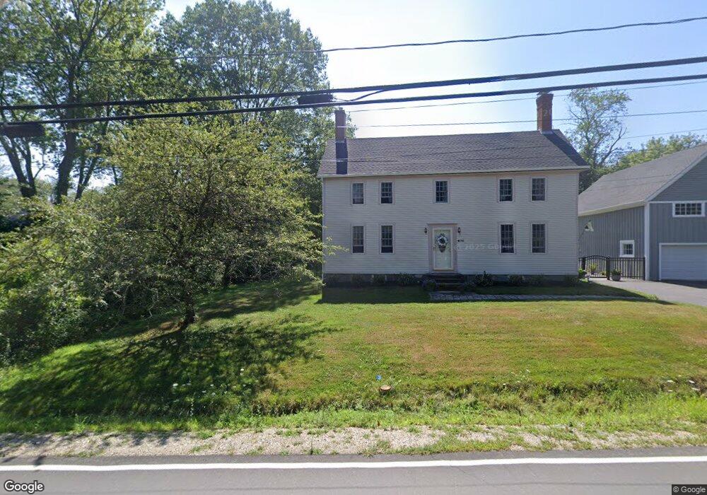
671 Main St Eliot, ME 03903
South Eliot NeighborhoodEstimated Value: $573,000 - $739,192
About This Home
Property Id: 64793
High Quality Well Maintained Property
Tile & Hardwood Floors
Walk-In Closet Master Bedroom
Includes On Premises Storage Shed
Quiet 2-Acre Setting
Occasional Relaxing Distant Tidal River Tugboat Horns
Located within 2-miles of A-1 Self Storage, 55 U.S. Route 1 Bypass, Kittery
7-Minutes to Portsmouth & Portsmouth Naval Ship Yard
2- Miles to I-95
Laundry Room Hook-Ups / Vented Clothes Dryer Included
Gas Sipping clean running monitor heater
Historically Uses 475+- gallons of propane per year
Large private exterior deck & yard
INCLUDES: Town water, town sewer, snow plowing, regularly performed lawn & landscaping care
Tenant pays electric, cable, propane heating fuel
Credit/Criminal Report by Landlord's office
Favorable rental history. 1st month rent, last month rent and $2,000 security deposit due at signing of 1-yr lease
Limit 2-occupants
No smoking, no pet(s), no animal(s) due to allergies
Available Aug 1, 2025
Please Call If Interested
Home Values in the Area
Average Home Value in this Area
Property History
| Date | Event | Price | Change | Sq Ft Price |
|---|---|---|---|---|
| 08/05/2025 08/05/25 | Off Market | $2,295 | -- | -- |
| 07/14/2025 07/14/25 | Price Changed | $2,295 | -4.2% | $2 / Sq Ft |
| 07/06/2025 07/06/25 | Price Changed | $2,395 | -0.2% | $2 / Sq Ft |
| 07/01/2025 07/01/25 | Price Changed | $2,400 | -4.0% | $2 / Sq Ft |
| 06/16/2025 06/16/25 | Price Changed | $2,500 | 0.0% | $2 / Sq Ft |
| 06/16/2025 06/16/25 | For Rent | $2,500 | +4.2% | -- |
| 06/04/2025 06/04/25 | Off Market | $2,400 | -- | -- |
| 05/09/2025 05/09/25 | For Rent | $2,400 | -- | -- |
Tax History Compared to Growth
Tax History
| Year | Tax Paid | Tax Assessment Tax Assessment Total Assessment is a certain percentage of the fair market value that is determined by local assessors to be the total taxable value of land and additions on the property. | Land | Improvement |
|---|---|---|---|---|
| 2024 | $6,141 | $518,200 | $143,800 | $374,400 |
| 2023 | $6,069 | $495,400 | $137,400 | $358,000 |
| 2022 | $5,795 | $478,900 | $137,400 | $341,500 |
| 2021 | $4,604 | $341,000 | $126,700 | $214,300 |
| 2020 | $4,600 | $312,900 | $121,400 | $191,500 |
| 2019 | $4,600 | $312,900 | $121,400 | $191,500 |
| 2018 | $1,530 | $312,900 | $121,400 | $191,500 |
| 2017 | $1,479 | $312,900 | $121,400 | $191,500 |
| 2016 | $39,265 | $312,900 | $121,400 | $191,500 |
| 2015 | $4,381 | $312,900 | $121,400 | $191,500 |
| 2014 | $4,318 | $312,900 | $121,400 | $191,500 |
| 2013 | $4,121 | $312,900 | $121,400 | $191,500 |
Map
- 15 Shipping Ln
- 10 Shipping Ln
- 493 Main St
- 1092 State Rd
- 1192 State Rd
- 14 Grover Ave
- 32 Grover Ave
- 0 Franks Fort Island Unit 1631886
- 39 Albacore Way
- 39 Albacore Way Unit A
- 638 Kearsarge Way
- 3 Shearwater Dr Unit 1900
- 19 Shearwater Dr Unit 1903
- 15 Shearwater Dr Unit 1902
- 37 Shearwater Dr Unit 1906
- 201 Kearsarge Way
- 51 Granite St
- 14 Birch St
- 1338 Woodbury Ave Unit 10
- 7 Fernald Rd