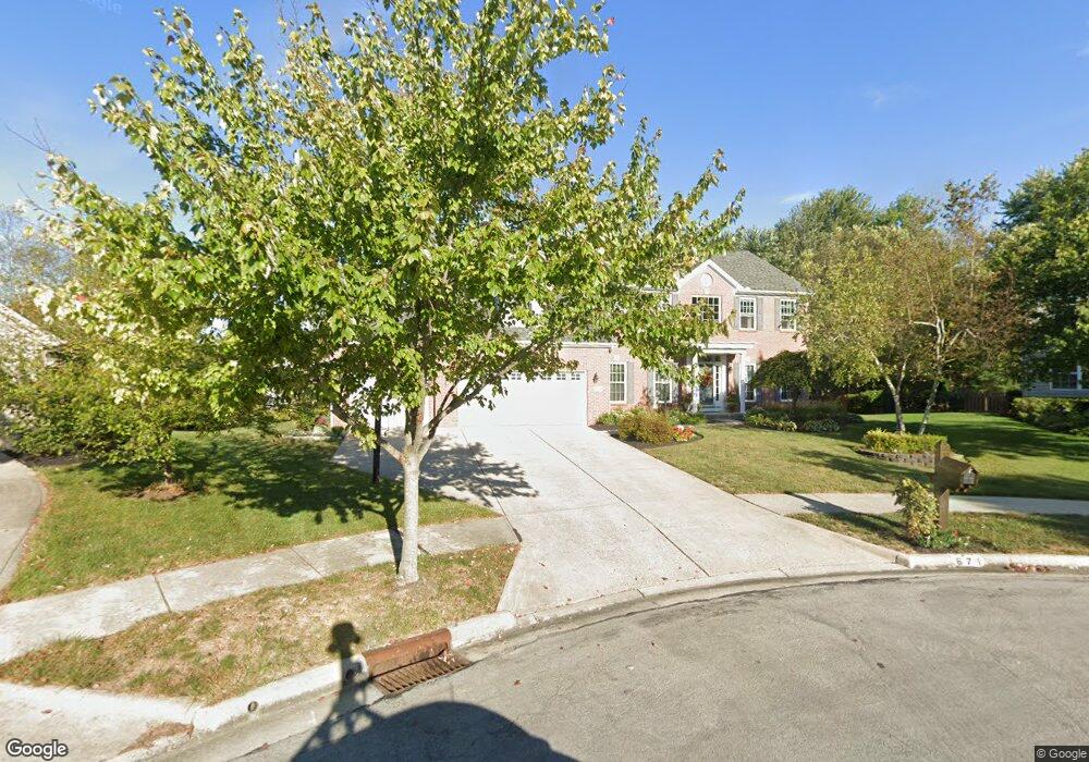
671 Sea Shell Ct Westerville, OH 43082
Genoa NeighborhoodEstimated Value: $633,000 - $691,000
4
Beds
3
Baths
3,061
Sq Ft
$212/Sq Ft
Est. Value
About This Home
This home is located at 671 Sea Shell Ct, Westerville, OH 43082 and is currently estimated at $650,460, approximately $212 per square foot. 671 Sea Shell Ct is a home located in Delaware County with nearby schools including Robert Frost Elementary School, Heritage Middle School, and Westerville-North High School.
Ownership History
Date
Name
Owned For
Owner Type
Purchase Details
Closed on
Nov 10, 1998
Sold by
Rockford Homes Inc
Bought by
Lynskey Mark F and Lynskey Sandra L
Current Estimated Value
Home Financials for this Owner
Home Financials are based on the most recent Mortgage that was taken out on this home.
Original Mortgage
$223,000
Outstanding Balance
$49,232
Interest Rate
6.72%
Mortgage Type
New Conventional
Estimated Equity
$601,228
Purchase Details
Closed on
Jun 26, 1998
Sold by
Sunbury Highlands Ltd
Bought by
Rockford Homes Inc
Create a Home Valuation Report for This Property
The Home Valuation Report is an in-depth analysis detailing your home's value as well as a comparison with similar homes in the area
Home Values in the Area
Average Home Value in this Area
Purchase History
| Date | Buyer | Sale Price | Title Company |
|---|---|---|---|
| Lynskey Mark F | $255,000 | -- | |
| Rockford Homes Inc | $90,000 | -- |
Source: Public Records
Mortgage History
| Date | Status | Borrower | Loan Amount |
|---|---|---|---|
| Open | Lynskey Mark F | $223,000 |
Source: Public Records
Tax History Compared to Growth
Tax History
| Year | Tax Paid | Tax Assessment Tax Assessment Total Assessment is a certain percentage of the fair market value that is determined by local assessors to be the total taxable value of land and additions on the property. | Land | Improvement |
|---|---|---|---|---|
| 2024 | $9,275 | $182,040 | $39,760 | $142,280 |
| 2023 | $9,168 | $182,040 | $39,760 | $142,280 |
| 2022 | $8,800 | $135,180 | $25,100 | $110,080 |
| 2021 | $8,875 | $135,180 | $25,100 | $110,080 |
| 2020 | $8,934 | $135,180 | $25,100 | $110,080 |
| 2019 | $8,190 | $118,380 | $25,100 | $93,280 |
| 2018 | $8,052 | $118,380 | $25,100 | $93,280 |
| 2017 | $7,908 | $110,260 | $22,020 | $88,240 |
| 2016 | $8,182 | $110,260 | $22,020 | $88,240 |
| 2015 | $7,827 | $110,260 | $22,020 | $88,240 |
| 2014 | $7,905 | $110,260 | $22,020 | $88,240 |
| 2013 | $7,665 | $106,860 | $22,020 | $84,840 |
Source: Public Records
Map
Nearby Homes
- 1155 Ashford Ct
- 7568 Park Bend Ct
- 6618 Wild Rose Ln
- 9119 Robinhood Cir
- 6460 Bromfield Dr
- 6685 Tussic Street Rd
- 6611 Lake of the Woods Point
- 974 Lakeland Dr
- 9200 Knoll Dr
- 7663 Rolling Ridge Way
- 656 Olde Mill Dr
- 8369 Manitou Dr
- 912 Lakeway Ct E
- 73 Keethler Dr S
- 718 Sugar Ct
- 754 Kingsmead Rd Unit 18754
- 5840 Heron Ct
- 7268 Clancy Way
- 7581 Lanetta Ln
- 4485 Smothers Rd
- 674 Sea Shell Ct
- 676 Freshwater Ct
- 665 Sea Shell Ct
- 668 Freshwater Ct
- 661 Sea Shell Ct
- 672 Sea Shell Ct
- 680 Freshwater Ct
- 660 Freshwater Ct
- 664 Sea Shell Ct
- 652 Freshwater Ct
- 1232 Sea Shell Dr
- 675 Freshwater Ct
- 1244 Sea Shell Dr
- 667 Freshwater Ct
- 8120 Maxtown Rd
- 644 Freshwater Ct
- 659 Freshwater Ct
- 1228 Sea Shell Dr
- 8080 Maxtown Rd
- 651 Freshwater Ct