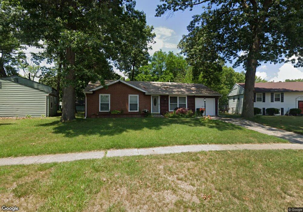
6710 Burnham Green Rd Toledo, OH 43615
Estimated Value: $142,000 - $192,000
3
Beds
1
Bath
1,026
Sq Ft
$161/Sq Ft
Est. Value
About This Home
This home is located at 6710 Burnham Green Rd, Toledo, OH 43615 and is currently estimated at $165,469, approximately $161 per square foot. 6710 Burnham Green Rd is a home located in Lucas County with nearby schools including Dorr Street Elementary School, Springfield Middle School, and Springfield High School.
Ownership History
Date
Name
Owned For
Owner Type
Purchase Details
Closed on
Apr 3, 2008
Sold by
Sherrick Victor H
Bought by
Gedert Cindy C
Current Estimated Value
Purchase Details
Closed on
May 27, 1998
Sold by
Wallace Brent N
Bought by
Sherrick Victor H and Gedert Cindy C
Home Financials for this Owner
Home Financials are based on the most recent Mortgage that was taken out on this home.
Original Mortgage
$83,793
Interest Rate
7.27%
Mortgage Type
FHA
Purchase Details
Closed on
Dec 1, 1993
Sold by
Kott Robert R
Purchase Details
Closed on
Sep 27, 1988
Sold by
Kott R S and S S
Create a Home Valuation Report for This Property
The Home Valuation Report is an in-depth analysis detailing your home's value as well as a comparison with similar homes in the area
Home Values in the Area
Average Home Value in this Area
Purchase History
| Date | Buyer | Sale Price | Title Company |
|---|---|---|---|
| Gedert Cindy C | -- | Attorney | |
| Sherrick Victor H | $83,900 | Midland | |
| -- | $62,000 | -- | |
| -- | -- | -- |
Source: Public Records
Mortgage History
| Date | Status | Borrower | Loan Amount |
|---|---|---|---|
| Previous Owner | Sherrick Victor H | $83,793 |
Source: Public Records
Tax History Compared to Growth
Tax History
| Year | Tax Paid | Tax Assessment Tax Assessment Total Assessment is a certain percentage of the fair market value that is determined by local assessors to be the total taxable value of land and additions on the property. | Land | Improvement |
|---|---|---|---|---|
| 2024 | $1,529 | $49,945 | $13,020 | $36,925 |
| 2023 | $2,673 | $38,220 | $10,290 | $27,930 |
| 2022 | $2,663 | $38,220 | $10,290 | $27,930 |
| 2021 | $2,522 | $38,220 | $10,290 | $27,930 |
| 2020 | $2,327 | $32,165 | $8,330 | $23,835 |
| 2019 | $2,273 | $32,165 | $8,330 | $23,835 |
| 2018 | $2,251 | $32,165 | $8,330 | $23,835 |
| 2017 | $2,245 | $29,645 | $7,910 | $21,735 |
| 2016 | $2,265 | $84,700 | $22,600 | $62,100 |
| 2015 | $2,261 | $84,700 | $22,600 | $62,100 |
| 2014 | $2,000 | $28,500 | $7,600 | $20,900 |
| 2013 | $2,000 | $28,500 | $7,600 | $20,900 |
Source: Public Records
Map
Nearby Homes
- 319 S Mccord Rd
- 6855 Wharton Rd
- 324 Harefoote St
- 342 S Harefoote St
- 352 Cheswick St
- 508 Crystal Lake Dr
- 617 & 621 S Mccord Rd
- 6607 Hill Ave
- 426 Cheswick Rd
- 217 Pebble Beach Dr
- 127 N Dorcas Rd
- 7109 Springfield Hills Dr S
- 642 Diana Dr
- 6339 Hill Ave
- 640 Quigley St
- 7238 Lilac Ct
- 134 Deerfield Dr
- 7255 Apache Trail
- 112 Deerfield Dr
- 6130 White Oak Dr
- 6704 Burnham Green Rd
- 229 Danesmoor Rd
- 221 Danesmoor Rd
- 166 Bromwich Ln
- 215 Danesmoor Rd
- 156 Bromwich Ln
- 6705 Burnham Green Rd
- 207 Danesmoor Rd
- 150 Bromwich Ln
- 232 Danesmoor Rd
- 241 Danesmoor Rd
- 6701 Burnham Green Rd
- 201 Danesmoor Rd
- 6653 Burnham Green Rd
- 144 Bromwich Ln
- 6730 Burnham Green Rd
- 161 Bromwich Ln
- 244 Danesmoor Rd
- 6649 Burnham Green Rd
- 228 Danesmoor Rd