T
Seller's Agent in 2019
Tim Kizziar
Stellar Realty Northwest

Estimated Value: $683,909 - $834,000
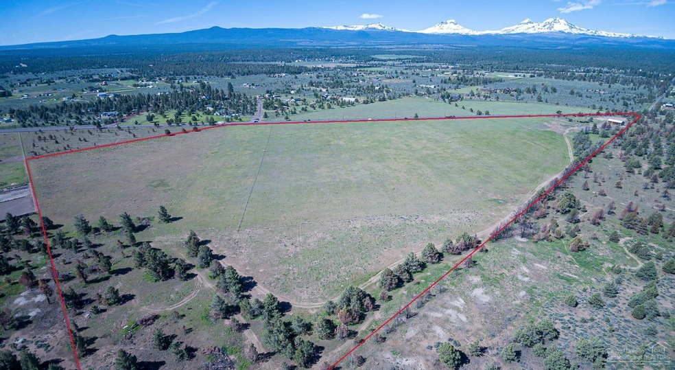
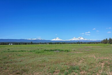
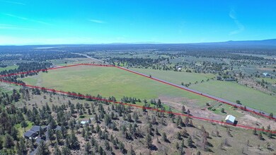
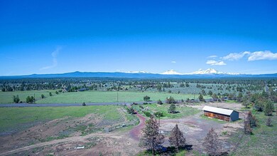
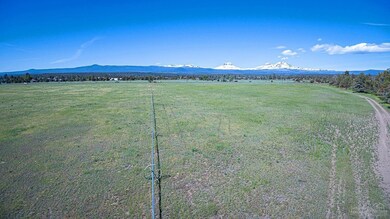
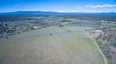
Hard to find 51.65 acres of EFU zoned land. Property features: 35.1 acres of 1895 well irrigation water rights; Huge mountain views; 2 existing wells (domestic & irrigation); Installed septic system; 1920 square foot farm building with additional loft space; almost a half mile of Hwy 20 frontage which provides a fantastic agritourism opportunity. Opportunity to build a replacement home (previous home removed due to fire in 2018), or farmhand home, and possibly an additional farm dwelling. All this within the Sisters school district with easy access to Bend or Sisters.
Last Agent to Sell the Property
Tim Kizziar
Stellar Realty Northwest License #201212058 Listed on: 06/07/2019
| Date | Buyer | Sale Price | Title Company |
|---|---|---|---|
| Botug Llc | $425,000 | Western Title & Escrow | |
| Degaetano Benny A | -- | None Available |
| Date | Event | Price | List to Sale | Price per Sq Ft |
|---|---|---|---|---|
| 08/14/2019 08/14/19 | Sold | $425,000 | 0.0% | $398 / Sq Ft |
| 06/18/2019 06/18/19 | Pending | -- | -- | -- |
| 06/07/2019 06/07/19 | For Sale | $425,000 | -- | $398 / Sq Ft |
| Year | Tax Paid | Tax Assessment Tax Assessment Total Assessment is a certain percentage of the fair market value that is determined by local assessors to be the total taxable value of land and additions on the property. | Land | Improvement |
|---|---|---|---|---|
| 2025 | $830 | $55,916 | -- | -- |
| 2024 | $808 | $54,666 | -- | -- |
| 2023 | $790 | $53,456 | $0 | $0 |
| 2022 | $732 | $51,136 | $0 | $0 |
| 2021 | $704 | $50,026 | $0 | $0 |
| 2020 | $673 | $50,026 | $0 | $0 |
| 2019 | $304 | $48,946 | $0 | $0 |
| 2018 | $923 | $93,706 | $0 | $0 |
| 2017 | $895 | $91,356 | $0 | $0 |
| 2016 | $900 | $90,074 | $0 | $0 |
| 2015 | $849 | $87,853 | $0 | $0 |
| 2014 | $800 | $85,702 | $0 | $0 |
T
Seller's Agent in 2019
Tim Kizziar
Stellar Realty Northwest

Buyer's Agent in 2019
Brian Intlekofer
Obsidian Real Estate Group
(541) 633-7772
60 Total Sales
Source: Oregon Datashare
MLS Number: 201905285
APN: 130902
Disclaimer: Certain information contained herein is derived from information provided by parties other than Homes.com. All information provided is deemed reliable, but is not guaranteed to be accurate and should be independently verified.
![]() © 2025 Oregon Datashare (KCAR | MLSCO | SOMLS). All rights reserved. The data relating to real estate for sale on this web site comes in part from the Internet Data Exchange Program of the Oregon Datashare. Real estate listings held by IDX Brokerage firms other than Ten-X are marked with the Internet Data Exchange logo or the Internet Data Exchange thumbnail logo and detailed information about them includes the name of the listing Brokers. Information provided is for consumers' personal, non-commercial use and may not be used for any purpose other than to identify prospective properties the viewer may be interested in purchasing. The consumer will not copy, retransmit nor redistribute any of the content from this website. Information provided is deemed reliable, but not guaranteed.
© 2025 Oregon Datashare (KCAR | MLSCO | SOMLS). All rights reserved. The data relating to real estate for sale on this web site comes in part from the Internet Data Exchange Program of the Oregon Datashare. Real estate listings held by IDX Brokerage firms other than Ten-X are marked with the Internet Data Exchange logo or the Internet Data Exchange thumbnail logo and detailed information about them includes the name of the listing Brokers. Information provided is for consumers' personal, non-commercial use and may not be used for any purpose other than to identify prospective properties the viewer may be interested in purchasing. The consumer will not copy, retransmit nor redistribute any of the content from this website. Information provided is deemed reliable, but not guaranteed.