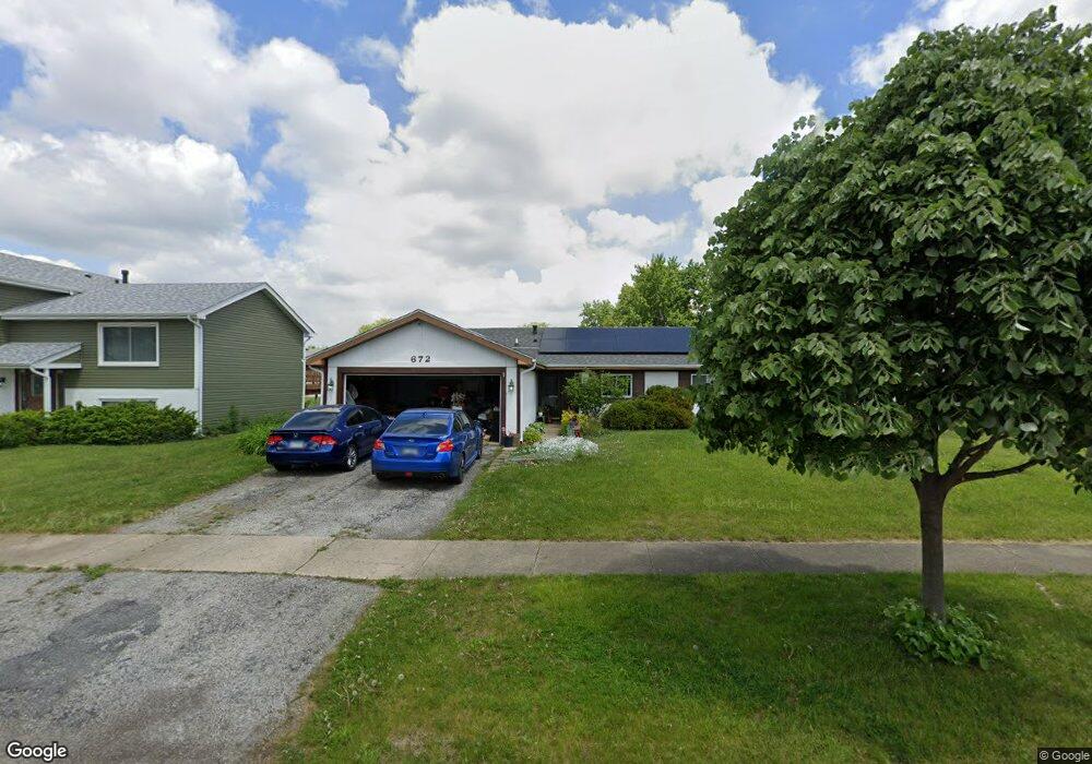
672 Chesapeake Dr Bolingbrook, IL 60440
East Bolingbrook NeighborhoodEstimated Value: $286,000 - $300,000
3
Beds
1
Bath
1,322
Sq Ft
$222/Sq Ft
Est. Value
About This Home
This home is located at 672 Chesapeake Dr, Bolingbrook, IL 60440 and is currently estimated at $292,962, approximately $221 per square foot. 672 Chesapeake Dr is a home located in Will County with nearby schools including John R Tibbott Elementary School, Hubert H Humphrey Middle School, and Bolingbrook High School.
Ownership History
Date
Name
Owned For
Owner Type
Purchase Details
Closed on
Feb 29, 2008
Sold by
Harris Mary K
Bought by
Lafond Mike and Lafond La Fond
Current Estimated Value
Home Financials for this Owner
Home Financials are based on the most recent Mortgage that was taken out on this home.
Original Mortgage
$166,358
Interest Rate
6.17%
Mortgage Type
FHA
Purchase Details
Closed on
Jul 2, 1997
Sold by
Bachman Donald E
Bought by
Harris Donald P and Harris Mary K
Home Financials for this Owner
Home Financials are based on the most recent Mortgage that was taken out on this home.
Original Mortgage
$54,900
Interest Rate
8.01%
Create a Home Valuation Report for This Property
The Home Valuation Report is an in-depth analysis detailing your home's value as well as a comparison with similar homes in the area
Home Values in the Area
Average Home Value in this Area
Purchase History
| Date | Buyer | Sale Price | Title Company |
|---|---|---|---|
| Lafond Mike | $169,000 | Law Title Insurance | |
| Harris Donald P | $105,000 | -- |
Source: Public Records
Mortgage History
| Date | Status | Borrower | Loan Amount |
|---|---|---|---|
| Previous Owner | Lafond Mike | $166,358 | |
| Previous Owner | Harris Donald P | $54,900 |
Source: Public Records
Tax History
| Year | Tax Paid | Tax Assessment Tax Assessment Total Assessment is a certain percentage of the fair market value that is determined by local assessors to be the total taxable value of land and additions on the property. | Land | Improvement |
|---|---|---|---|---|
| 2024 | $6,808 | $81,713 | $17,403 | $64,310 |
| 2023 | $6,808 | $73,523 | $15,659 | $57,864 |
| 2022 | $5,959 | $66,284 | $14,117 | $52,167 |
| 2021 | $5,636 | $61,977 | $13,200 | $48,777 |
| 2020 | $5,456 | $59,939 | $12,766 | $47,173 |
| 2019 | $5,271 | $57,085 | $12,158 | $44,927 |
| 2018 | $5,052 | $54,638 | $11,637 | $43,001 |
| 2017 | $4,799 | $51,789 | $11,030 | $40,759 |
| 2016 | $4,650 | $49,300 | $10,500 | $38,800 |
| 2015 | $4,328 | $47,300 | $10,100 | $37,200 |
| 2014 | $4,328 | $45,000 | $9,600 | $35,400 |
| 2013 | $4,328 | $50,000 | $10,700 | $39,300 |
Source: Public Records
Map
Nearby Homes
- 564 White Oak Rd
- 317 Homestead Dr
- 320 Homestead Dr
- 246 Homewood Dr
- 271 Stonegate Rd
- 473 Rockhurst Rd
- 526 King Arthur Way
- 124 Seabury Rd
- 404 Galahad Rd
- 207 Seabury Rd
- 220 N Ashbury Ave
- 325 Rockhurst Rd
- 421 N Ashbury Ave
- 409 N Ashbury Ave
- 598 Miner Dr
- 505 Goodwin Dr
- 411 Assembly Dr
- 354 Aaron Ln
- 547 Goodwin Dr
- 234 Malibu Dr
- 668 Chesapeake Dr
- 676 Chesapeake Dr
- 664 Chesapeake Dr
- 671 Niagara Dr
- 680 Chesapeake Dr
- 675 Niagara Dr
- 667 Niagara Dr
- 679 Niagara Dr
- 663 Niagara Dr
- 671 Chesapeake Dr
- 667 Chesapeake Dr
- 660 Chesapeake Dr
- 675 Chesapeake Dr
- 684 Chesapeake Dr
- 663 Chesapeake Dr
- 683 Niagara Dr
- 679 Chesapeake Dr
- 659 Niagara Dr
- 656 Chesapeake Dr
- 688 Chesapeake Dr
Your Personal Tour Guide
Ask me questions while you tour the home.