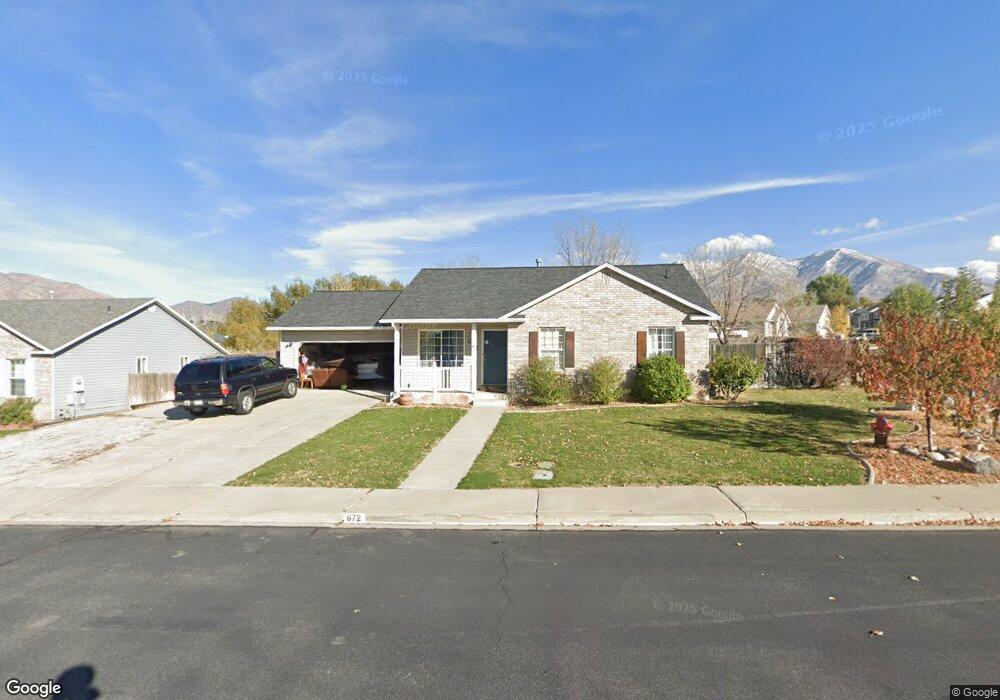
672 N 1120 E Spanish Fork, UT 84660
Estimated Value: $424,000 - $471,000
3
Beds
2
Baths
1,149
Sq Ft
$385/Sq Ft
Est. Value
About This Home
This home is located at 672 N 1120 E, Spanish Fork, UT 84660 and is currently estimated at $442,784, approximately $385 per square foot. 672 N 1120 E is a home located in Utah County with nearby schools including Rees Elementary School, Mapleton Junior High School, and Maple Mountain High School.
Ownership History
Date
Name
Owned For
Owner Type
Purchase Details
Closed on
Nov 4, 2024
Sold by
Christiansen Justin
Bought by
Mitchell Ronald Sean and Mitchell Beverly
Current Estimated Value
Home Financials for this Owner
Home Financials are based on the most recent Mortgage that was taken out on this home.
Original Mortgage
$328,000
Outstanding Balance
$323,347
Interest Rate
6.08%
Mortgage Type
New Conventional
Estimated Equity
$119,437
Purchase Details
Closed on
May 7, 2018
Sold by
Christiansen Justin and Rodriguez Marielis
Bought by
Christiansen Justin
Purchase Details
Closed on
Apr 16, 2018
Sold by
Christiansen Justin and Rodriguez Marielis
Bought by
Christiansen Justin
Purchase Details
Closed on
Mar 20, 2012
Sold by
Christiansen Justin
Bought by
Christiansen Justin and Rodriguez Marielis
Home Financials for this Owner
Home Financials are based on the most recent Mortgage that was taken out on this home.
Original Mortgage
$119,937
Interest Rate
3.75%
Mortgage Type
FHA
Purchase Details
Closed on
May 14, 2004
Sold by
Draper Bradley J and Draper Addie S
Bought by
Dent William P and Dent Christina M
Home Financials for this Owner
Home Financials are based on the most recent Mortgage that was taken out on this home.
Original Mortgage
$108,000
Interest Rate
5%
Mortgage Type
Stand Alone First
Purchase Details
Closed on
Feb 23, 1998
Sold by
Watson Michael P and Watson Heather K
Bought by
Draper Bradley J and Draper Addie S
Purchase Details
Closed on
Jul 7, 1997
Sold by
Watson Michael P and Watson Heather K
Bought by
Maddi Corp
Home Financials for this Owner
Home Financials are based on the most recent Mortgage that was taken out on this home.
Original Mortgage
$216,000
Interest Rate
7.92%
Mortgage Type
Seller Take Back
Purchase Details
Closed on
May 12, 1997
Sold by
Mitchell Martin W and Mitchell Virginia S
Bought by
Watson Michael P and Watson Heather K
Home Financials for this Owner
Home Financials are based on the most recent Mortgage that was taken out on this home.
Original Mortgage
$216,000
Interest Rate
7.92%
Mortgage Type
Seller Take Back
Create a Home Valuation Report for This Property
The Home Valuation Report is an in-depth analysis detailing your home's value as well as a comparison with similar homes in the area
Home Values in the Area
Average Home Value in this Area
Purchase History
| Date | Buyer | Sale Price | Title Company |
|---|---|---|---|
| Mitchell Ronald Sean | -- | Northern Title | |
| Christiansen Justin | -- | Recorded For Northern Title | |
| Christiansen Justin | -- | None Available | |
| Christiansen Justin | -- | None Available | |
| Christiansen Justin | -- | None Available | |
| Dent William P | -- | Inwest Title Services Inc | |
| Draper Bradley J | -- | Wasatch Land & Title | |
| Maddi Corp | -- | Equity Title Agency Inc | |
| Watson Michael P | -- | Fidelity Title |
Source: Public Records
Mortgage History
| Date | Status | Borrower | Loan Amount |
|---|---|---|---|
| Open | Mitchell Ronald Sean | $328,000 | |
| Previous Owner | Christiansen Justin | $119,937 | |
| Previous Owner | Christiansen Justin | $5,000 | |
| Previous Owner | Dent William P | $108,000 | |
| Previous Owner | Maddi Corp | $216,000 | |
| Previous Owner | Watson Michael P | $90,374 | |
| Closed | Dent William P | $27,000 |
Source: Public Records
Tax History
| Year | Tax Paid | Tax Assessment Tax Assessment Total Assessment is a certain percentage of the fair market value that is determined by local assessors to be the total taxable value of land and additions on the property. | Land | Improvement |
|---|---|---|---|---|
| 2025 | $1,979 | $221,100 | -- | -- |
| 2024 | $1,979 | $203,940 | $0 | $0 |
| 2023 | $2,013 | $207,735 | $0 | $0 |
| 2022 | $2,049 | $207,350 | $0 | $0 |
| 2021 | $1,754 | $284,000 | $92,000 | $192,000 |
| 2020 | $1,611 | $253,500 | $83,600 | $169,900 |
| 2019 | $1,354 | $224,300 | $76,600 | $147,700 |
| 2018 | $1,263 | $202,200 | $73,100 | $129,100 |
| 2017 | $1,104 | $94,985 | $0 | $0 |
| 2016 | $910 | $77,275 | $0 | $0 |
| 2015 | $827 | $69,410 | $0 | $0 |
| 2014 | $809 | $68,090 | $0 | $0 |
Source: Public Records
Map
Nearby Homes
- 1074 E 660 N
- 1238 E 680 N
- 1050 E 800 N Unit 1
- 1050 E 800 N Unit 5
- 1261 E 680 N
- 755 Black Horse Dr
- 708 N Black Horse Loop Unit 708
- 453 N 1210 E
- 822 N 1120 E
- 902 N 1120 E
- 1025 E 360 N Unit 5
- 1022 E 360 N Unit 27
- 991 E 360 N Unit 8
- 1163 E 920 N
- 2672 E 360 N Unit MRVL09
- 314 N 1070 E
- 998 E 260 N Unit 16
- 992 E 260 N Unit 15
- 284 N 1000 E
- 1108 E 260 N
Your Personal Tour Guide
Ask me questions while you tour the home.