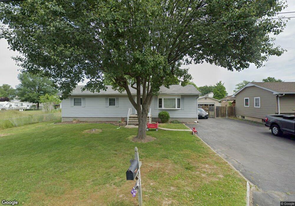
6720 Cornell Rd Middle River, MD 21220
Estimated Value: $342,000 - $428,840
3
Beds
3
Baths
2,544
Sq Ft
$151/Sq Ft
Est. Value
About This Home
This home is located at 6720 Cornell Rd, Middle River, MD 21220 and is currently estimated at $383,710, approximately $150 per square foot. 6720 Cornell Rd is a home located in Baltimore County with nearby schools including Chase Elementary School, Middle River Middle School, and Kenwood High.
Ownership History
Date
Name
Owned For
Owner Type
Purchase Details
Closed on
Apr 23, 2021
Sold by
Cannon Miranda Lee and Estate Of Richard H Cannon Iii
Bought by
Ickes Mitchell Eldon
Current Estimated Value
Home Financials for this Owner
Home Financials are based on the most recent Mortgage that was taken out on this home.
Original Mortgage
$266,750
Outstanding Balance
$240,843
Interest Rate
3%
Mortgage Type
New Conventional
Estimated Equity
$142,867
Purchase Details
Closed on
Aug 24, 2004
Sold by
Cannon Richard H
Bought by
Cannon Richard H
Purchase Details
Closed on
Apr 10, 2000
Sold by
Baglanis Lillian E
Bought by
Cannon Richard H and Cannon Tammi L
Purchase Details
Closed on
Nov 2, 1994
Sold by
Reiswig Rodger R
Bought by
Baglanis Lillian E
Home Financials for this Owner
Home Financials are based on the most recent Mortgage that was taken out on this home.
Original Mortgage
$120,000
Interest Rate
8.71%
Create a Home Valuation Report for This Property
The Home Valuation Report is an in-depth analysis detailing your home's value as well as a comparison with similar homes in the area
Purchase History
| Date | Buyer | Sale Price | Title Company |
|---|---|---|---|
| Ickes Mitchell Eldon | $275,000 | Lakeside Title Co | |
| Cannon Richard H | -- | -- | |
| Cannon Richard H | -- | -- | |
| Cannon Richard H | $169,999 | -- | |
| Baglanis Lillian E | $160,000 | -- |
Source: Public Records
Mortgage History
| Date | Status | Borrower | Loan Amount |
|---|---|---|---|
| Open | Ickes Mitchell Eldon | $266,750 | |
| Previous Owner | Baglanis Lillian E | $120,000 |
Source: Public Records
Tax History
| Year | Tax Paid | Tax Assessment Tax Assessment Total Assessment is a certain percentage of the fair market value that is determined by local assessors to be the total taxable value of land and additions on the property. | Land | Improvement |
|---|---|---|---|---|
| 2025 | $5,853 | $373,233 | -- | -- |
| 2024 | $5,853 | $349,367 | $0 | $0 |
| 2023 | $2,919 | $325,500 | $86,500 | $239,000 |
| 2022 | $5,088 | $303,367 | $0 | $0 |
| 2021 | $3,468 | $281,233 | $0 | $0 |
| 2020 | $3,140 | $259,100 | $86,500 | $172,600 |
| 2019 | $2,998 | $247,333 | $0 | $0 |
| 2018 | $3,370 | $235,567 | $0 | $0 |
| 2017 | $3,135 | $223,800 | $0 | $0 |
| 2016 | $3,184 | $223,800 | $0 | $0 |
| 2015 | $3,184 | $223,800 | $0 | $0 |
| 2014 | $3,184 | $233,800 | $0 | $0 |
Source: Public Records
Map
Nearby Homes
- 6714 Cornell Rd
- 6812 Schaadts Rd
- 13202 Cherwin Ave
- 7114 Oliver Beach Rd
- 7051 Greenbank Rd
- 6609 Blackhead Rd
- 7230 Gunpowder Rd
- 7316 Greenbank Rd
- 7343 Greenbank Rd
- 7361 Chesapeake Rd
- 116 Trails Way
- 6710 Camden St
- 6708 Camden St
- 6711 Greenleigh Ave
- 6707 Greenleigh Ave
- 6604 Queensbury St
- 6204 Ebenezer Rd
- 603 Harrington St
- 6642 Camden St
- 6623 Greenleigh Ave
- 6722 Cornell Rd
- 6724 Cornell Rd
- 6719 Harewood Park Dr
- 6717 Harewood Park Dr
- 6721 Harewood Park Dr
- 6717 Cornell Rd
- 6719 Cornell Rd
- 6710 Cornell Rd
- 6715 Harewood Park Dr
- 6723 Harewood Park Dr
- 6715 Cornell Rd
- 6721 Cornell Rd
- 6711 Cornell Rd
- 6711 Harewood Park Dr
- 12925 Loyola Rd
- 6801 Harewood Park Dr
- 6709 Harewood Park Dr
- 6706 Cornell Rd
- 6709 Cornell Rd
- 6801 Cornell Rd
Your Personal Tour Guide
Ask me questions while you tour the home.