Estimated Value: $182,000 - $272,000
4
Beds
2
Baths
1,926
Sq Ft
$120/Sq Ft
Est. Value
About This Home
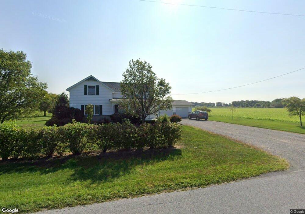
This home is located at 6720 Stewart Rd, Lima, OH 45807 and is currently estimated at $231,671, approximately $120 per square foot. 6720 Stewart Rd is a home with nearby schools including Bath Elementary School, Bath Middle School, and Bath High School.
Ownership History
Date
Name
Owned For
Owner Type
Purchase Details
Closed on
Jan 12, 2023
Sold by
Burkholder Matthew J and Burkholder Kendra E
Bought by
Burkholder Matthew J and Burkholder Kendra E
Current Estimated Value
Purchase Details
Closed on
Jun 22, 2010
Sold by
Boertje Cheryl A and Boertje Darwin W
Bought by
Burkholder Matthew J
Home Financials for this Owner
Home Financials are based on the most recent Mortgage that was taken out on this home.
Original Mortgage
$63,796
Interest Rate
4.86%
Mortgage Type
Purchase Money Mortgage
Create a Home Valuation Report for This Property
The Home Valuation Report is an in-depth analysis detailing your home's value as well as a comparison with similar homes in the area
Home Values in the Area
Average Home Value in this Area
Purchase History
| Date | Buyer | Sale Price | Title Company |
|---|---|---|---|
| Burkholder Matthew J | -- | -- | |
| Burkholder Matthew J | $75,500 | Attorney |
Source: Public Records
Mortgage History
| Date | Status | Borrower | Loan Amount |
|---|---|---|---|
| Previous Owner | Burkholder Matthew J | $63,796 |
Source: Public Records
Tax History Compared to Growth
Tax History
| Year | Tax Paid | Tax Assessment Tax Assessment Total Assessment is a certain percentage of the fair market value that is determined by local assessors to be the total taxable value of land and additions on the property. | Land | Improvement |
|---|---|---|---|---|
| 2024 | $2,397 | $59,050 | $14,560 | $44,490 |
| 2023 | $2,232 | $48,410 | $11,940 | $36,470 |
| 2022 | $2,382 | $48,410 | $11,940 | $36,470 |
| 2021 | $2,196 | $48,410 | $11,940 | $36,470 |
| 2020 | $1,912 | $39,380 | $11,550 | $27,830 |
| 2019 | $1,912 | $39,380 | $11,550 | $27,830 |
| 2018 | $1,829 | $39,380 | $11,550 | $27,830 |
| 2017 | $1,755 | $36,860 | $11,550 | $25,310 |
| 2016 | $1,810 | $36,860 | $11,550 | $25,310 |
| 2015 | $1,404 | $36,860 | $11,550 | $25,310 |
| 2014 | $1,404 | $29,090 | $11,550 | $17,540 |
| 2013 | $1,435 | $29,090 | $11,550 | $17,540 |
Source: Public Records
Map
Nearby Homes
- 220 Parklane Dr
- 201 Wall St
- 309 Wall St
- 6585 Ottawa Rd
- 300 Sweaney Ave
- 3456 Shearin Ave
- 3798 Kissing Hollow Dr
- 3270 Bonnieview Dr
- 108 Highland Lakes Dr
- 1679 E Bluelick Rd
- 4080 Brookshore Dr
- 4050 Brookshore Dr
- 4619 N Thayer Rd
- 0 N Dixie Hwy Unit 308796
- 0 N Dixie Hwy Unit 300253
- 0 Fraunfelter Unit 307817
- 0 N Eastown Rd Unit 1034495
- 5025 N Cool Rd
- 2525 W Lincoln Hwy
- 11059 Ottawa Rd
- 6933 Stewart Rd
- 2025 E Lincoln Hwy
- 6490 Stewart Rd
- 1940 E Lincoln Hwy
- 7047 Stewart Rd
- 1697 E Lincoln Hwy
- 2122 E Lincoln Hwy
- 1669 E Lincoln Hwy
- 1694 E Lincoln Hwy
- 2174 E Lincoln Hwy
- 1621 E Lincoln Hwy
- 2373 E Lincoln Hwy
- 2250 E Lincoln Hwy
- 1605 E Lincoln Hwy
- 247 E Main St
- 105 Lackey Dr
- 250 E Main St
- 239 W Main St
- 2367 E Lincoln Hwy
- 246 E Main St