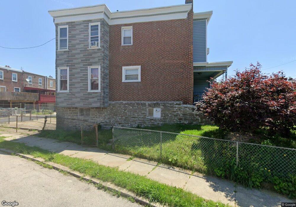
6721 Cornelius St Philadelphia, PA 19138
West Oak Lane NeighborhoodEstimated Value: $196,251 - $224,000
3
Beds
1
Bath
1,088
Sq Ft
$192/Sq Ft
Est. Value
About This Home
This home is located at 6721 Cornelius St, Philadelphia, PA 19138 and is currently estimated at $209,063, approximately $192 per square foot. 6721 Cornelius St is a home located in Philadelphia County with nearby schools including Anna B. Day School, Martin Luther King High School, and Mastery Charter School - Francis D. Pastorius Elemen.
Ownership History
Date
Name
Owned For
Owner Type
Purchase Details
Closed on
Apr 23, 2025
Sold by
Moss Joy A and Moss Hasan
Bought by
Moss Hasan
Current Estimated Value
Purchase Details
Closed on
Apr 18, 2013
Sold by
Moss Joy A and Estate Of Alfred Neighbors
Bought by
Moss Roy A
Purchase Details
Closed on
Dec 3, 1971
Bought by
Alfred Neighbors and Moss Loretta
Create a Home Valuation Report for This Property
The Home Valuation Report is an in-depth analysis detailing your home's value as well as a comparison with similar homes in the area
Home Values in the Area
Average Home Value in this Area
Purchase History
| Date | Buyer | Sale Price | Title Company |
|---|---|---|---|
| Moss Hasan | -- | None Listed On Document | |
| Moss Roy A | -- | None Available | |
| Alfred Neighbors | -- | -- |
Source: Public Records
Tax History Compared to Growth
Tax History
| Year | Tax Paid | Tax Assessment Tax Assessment Total Assessment is a certain percentage of the fair market value that is determined by local assessors to be the total taxable value of land and additions on the property. | Land | Improvement |
|---|---|---|---|---|
| 2025 | $2,158 | $192,100 | $38,420 | $153,680 |
| 2024 | $2,158 | $192,100 | $38,420 | $153,680 |
| 2023 | $2,158 | $154,200 | $30,840 | $123,360 |
| 2022 | $997 | $109,200 | $30,840 | $78,360 |
| 2021 | $1,627 | $0 | $0 | $0 |
| 2020 | $1,627 | $0 | $0 | $0 |
| 2019 | $1,813 | $0 | $0 | $0 |
| 2018 | $1,230 | $0 | $0 | $0 |
| 2017 | $1,650 | $0 | $0 | $0 |
| 2016 | $1,230 | $0 | $0 | $0 |
| 2015 | -- | $0 | $0 | $0 |
| 2014 | -- | $117,900 | $21,062 | $96,838 |
| 2012 | -- | $9,056 | $2,264 | $6,792 |
Source: Public Records
Map
Nearby Homes
- 1505 Beverly Rd
- 1537 Beverly Rd
- 7243 Mansfield Ave
- 6661 Cornelius St
- 1521 E Walnut Ln
- 6635 Hollis St
- 7258 Mansfield Ave
- 1544 Beverly Rd
- 1416-20 E Tulpehocken St
- 1559 E Pastorius St
- 1544 E Tulpehocken St
- 6620 Cornelius St
- 6332 E Wister St
- 1344 Narragansett St
- 6824 Rodney St
- 1413 E Washington Ln
- 5843 Crittenden St
- 5839 Crittenden St
- 5852 Crittenden St
- 5831 Crittenden St
- 6719 Cornelius St
- 6717 Cornelius St
- 6715 Cornelius St
- 6713 Cornelius St
- 6711 Cornelius St
- 1501 Beverly Rd
- 6709 Cornelius St
- 1503 Beverly Rd
- 6714 Hollis St
- 6716 Hollis St
- 6712 Hollis St
- 1507 Beverly Rd
- 6707 Cornelius St
- 6716 Cornelius St
- 6710 Hollis St
- 6726 Cornelius St
- 6720 Cornelius St
- 6722 Cornelius St
- 6718 Cornelius St
- 6724 Cornelius St