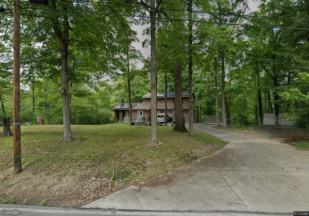
6723 Smith Rd Loveland, OH 45140
Estimated Value: $373,000 - $448,000
3
Beds
3
Baths
1,722
Sq Ft
$238/Sq Ft
Est. Value
About This Home
This home is located at 6723 Smith Rd, Loveland, OH 45140 and is currently estimated at $410,503, approximately $238 per square foot. 6723 Smith Rd is a home located in Clermont County with nearby schools including Loveland Primary School, Loveland Elementary School, and Loveland Intermediate School.
Ownership History
Date
Name
Owned For
Owner Type
Purchase Details
Closed on
Oct 22, 1999
Sold by
Reuss Lawrence R
Bought by
Allan Richard E and Allan Deborah L
Current Estimated Value
Home Financials for this Owner
Home Financials are based on the most recent Mortgage that was taken out on this home.
Original Mortgage
$144,000
Outstanding Balance
$53,904
Interest Rate
10.99%
Mortgage Type
New Conventional
Estimated Equity
$356,599
Purchase Details
Closed on
Jul 1, 1993
Purchase Details
Closed on
Jul 1, 1987
Create a Home Valuation Report for This Property
The Home Valuation Report is an in-depth analysis detailing your home's value as well as a comparison with similar homes in the area
Home Values in the Area
Average Home Value in this Area
Purchase History
| Date | Buyer | Sale Price | Title Company |
|---|---|---|---|
| Allan Richard E | $144,000 | -- | |
| -- | $127,500 | -- | |
| -- | $95,000 | -- |
Source: Public Records
Mortgage History
| Date | Status | Borrower | Loan Amount |
|---|---|---|---|
| Open | Allan Richard E | $144,000 |
Source: Public Records
Tax History Compared to Growth
Tax History
| Year | Tax Paid | Tax Assessment Tax Assessment Total Assessment is a certain percentage of the fair market value that is determined by local assessors to be the total taxable value of land and additions on the property. | Land | Improvement |
|---|---|---|---|---|
| 2024 | $3,739 | $91,670 | $29,860 | $61,810 |
| 2023 | $3,741 | $91,670 | $29,860 | $61,810 |
| 2022 | $2,957 | $64,960 | $21,140 | $43,820 |
| 2021 | $2,977 | $64,960 | $21,140 | $43,820 |
| 2020 | $2,977 | $64,960 | $21,140 | $43,820 |
| 2019 | $3,112 | $66,190 | $18,340 | $47,850 |
| 2018 | $3,229 | $66,190 | $18,340 | $47,850 |
| 2017 | $3,067 | $66,190 | $18,340 | $47,850 |
| 2016 | $3,067 | $60,170 | $16,660 | $43,510 |
| 2015 | $2,820 | $60,170 | $16,660 | $43,510 |
| 2014 | $2,820 | $60,170 | $16,660 | $43,510 |
| 2013 | $2,600 | $53,730 | $15,890 | $37,840 |
Source: Public Records
Map
Nearby Homes
- 6805 N Clarawill Dr
- 1277 Sand Trap Ct
- 1383 Stone Pillars Ct Unit Lot10
- Vaquero Plan at Stone Pillars
- Lexington Plan at Stone Pillars
- 6647 Saddleback Way
- 6650 Saddleback Way
- 6651 Saddleback Way
- 6651 Saddleback Way Unit Lot13
- 6853 Obannon Bluff
- 1487 Sawgrass Ridge Dr
- 6881 Paxton Rd
- 6646 Gentlewind Ct
- 6875 Stonehedge Cir
- 6874 Clubside Dr
- 962 Paul Vista Dr
- 6139 Misty Creek Dr
- Brookside Plan at Oakridge Estates - Signature Series
- Shaker Run Plan at Oakridge Estates - Signature Series
- Medinah Plan at Oakridge Estates - Signature Series
- 6721 Smith Rd
- 6722 Smith Rd
- 6719 Smith Rd
- 6725 Smith Rd
- 6725 Smith Rd
- 6725 Smith Rd Unit A
- A Smith Rd
- 6720 Smith Rd
- 6717 Smith Rd
- 6724 Smith Rd
- 6726 Smith Rd
- 6718 Smith Rd
- 6715 Smith Rd
- 6727 1/2 Smith Rd
- 1230 Serenity Springs Dr
- 6727 Smith Rd
- 6727 Smith Rd
- 1231 Serenity Springs
- 6728 Smith Rd
- 6716 Smith Rd