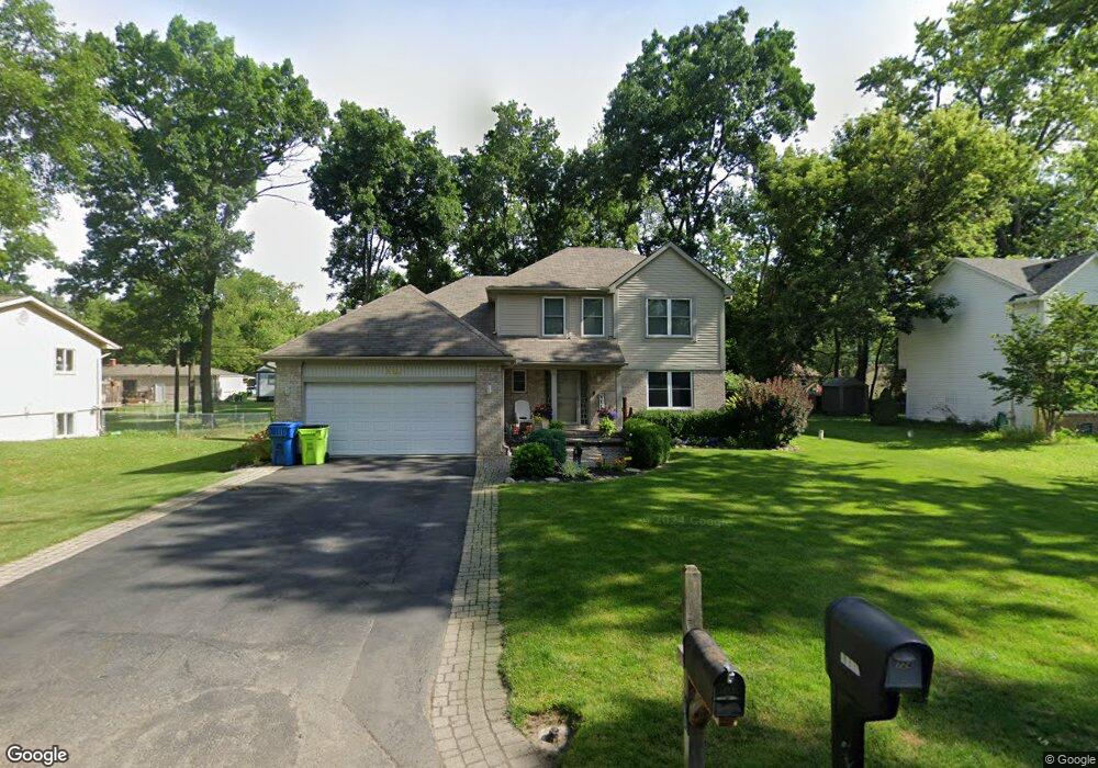
6724 Buckland Ave West Bloomfield, MI 48324
Estimated Value: $405,000 - $452,000
4
Beds
3
Baths
2,010
Sq Ft
$214/Sq Ft
Est. Value
About This Home
This home is located at 6724 Buckland Ave, West Bloomfield, MI 48324 and is currently estimated at $430,790, approximately $214 per square foot. 6724 Buckland Ave is a home located in Oakland County with nearby schools including Our Lady Of Refuge School and St Mary's Preparatory School.
Ownership History
Date
Name
Owned For
Owner Type
Purchase Details
Closed on
Sep 30, 2005
Sold by
Sommerfeld Avery and Sommerfeld Helene
Bought by
Pardington James J and Pardington Sandra
Current Estimated Value
Home Financials for this Owner
Home Financials are based on the most recent Mortgage that was taken out on this home.
Original Mortgage
$230,850
Outstanding Balance
$124,106
Interest Rate
5.83%
Mortgage Type
Fannie Mae Freddie Mac
Estimated Equity
$306,684
Create a Home Valuation Report for This Property
The Home Valuation Report is an in-depth analysis detailing your home's value as well as a comparison with similar homes in the area
Home Values in the Area
Average Home Value in this Area
Purchase History
| Date | Buyer | Sale Price | Title Company |
|---|---|---|---|
| Pardington James J | $288,600 | Title Express Agency |
Source: Public Records
Mortgage History
| Date | Status | Borrower | Loan Amount |
|---|---|---|---|
| Open | Pardington James J | $230,850 |
Source: Public Records
Tax History Compared to Growth
Tax History
| Year | Tax Paid | Tax Assessment Tax Assessment Total Assessment is a certain percentage of the fair market value that is determined by local assessors to be the total taxable value of land and additions on the property. | Land | Improvement |
|---|---|---|---|---|
| 2024 | $2,780 | $175,580 | $0 | $0 |
| 2022 | $2,662 | $163,390 | $40,390 | $123,000 |
| 2021 | $4,046 | $156,090 | $0 | $0 |
| 2020 | $2,609 | $148,900 | $40,390 | $108,510 |
| 2018 | $3,901 | $129,250 | $40,390 | $88,860 |
| 2015 | -- | $109,700 | $0 | $0 |
| 2014 | -- | $101,990 | $0 | $0 |
| 2011 | -- | $89,720 | $0 | $0 |
Source: Public Records
Map
Nearby Homes
- 6768 Buckland Ave
- 3950 Bradmore Ave
- 3965 Carrick Ave
- 3632 Fieldview Ave
- 6903 Dandison Blvd
- 3991 Fieldview Ave
- 3641 Green Lake Rd
- 4066 Green Lake Rd
- 0000 Langtoft
- 6675 Langtoft St
- 6978 Colony Dr
- 6707 Heatherwood Dr
- 7146 Arrowood Dr
- 3701 Northwood
- 6420 Commerce Rd
- 4245 Bunker Ave
- 4442 Borland St
- 7369 Sweetbriar
- 4335 Crestdale Ave
- 4212 Greendale Ave
- 6710 Buckland Ave
- 6738 Buckland Ave
- 6723 Buckland Ave
- 6729 Meadowfield St
- 6731 Buckland Ave
- 6670 Buckland Ave
- 6711 Buckland Ave
- 6743 Meadowfield St
- 6715 Meadowfield St
- 6735 Buckland Ave
- 6752 Buckland Ave
- 6759 Meadowfield St
- 6760 Buckland Ave
- 6748 Grassland Ave
- 6703 Meadowfield St
- 6675 Buckland Ave
- 6724 Grassland Ave
- 6752 Grassland Ave
- 6771 Meadowfield St
- 6657 Buckland Ave