K
Seller's Agent in 2026
Kimberly Lodge
The Agency Hall & Hunter
(248) 644-3500
3 in this area
12 Total Sales
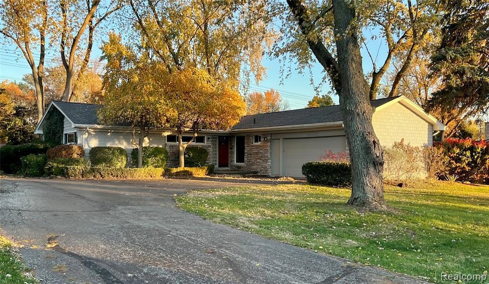
Welcome to your dream home! This beautiful ranch offers 3 bedrooms and 2 1/2 bathrooms. Almost 1900 square feet, and is perfect for anyone looking for a spacious retreat. Nestled in the heart of Bloomfield Twp., and across the street from the prestigious South Course of Oakland Hills Country Club. Step inside to a bright and airy living space. Large windows enhance the surroundings. The living room enjoys a cozy fireplace and is open to the dining room. The modern kitchen has custom rich cabinetry, granite countertops, high-end stainless steel appliances, and a breakfast nook. Gleaming hardwood floors throughout the home, with ceramic tile in the full baths. The floor plan is ideal for entertaining and everyday living. Primary Suite offers a luxurious bath with an Euro shower. A second patio door also provides access to the large private fenced-in backyard with lush landscaping, a stone patio, and a hot tub. New roof, new furnace, new hot water tank. Upgrades Galore. Wonderful convenient location close to shopping and restaurants. Minutes from downtown Birmingham. Award-winning Birmingham Schools. Just unpack!
Last Agent to Sell the Property
The Agency Hall & Hunter License #6501442882 Listed on: 11/08/2025

| Date | Type | Sale Price | Title Company |
|---|---|---|---|
| Warranty Deed | $550,000 | Equity Title | |
| Deed | $149,500 | -- |
| Date | Status | Loan Amount | Loan Type |
|---|---|---|---|
| Open | $522,500 | New Conventional | |
| Previous Owner | $119,600 | New Conventional |
| Date | Event | Price | List to Sale | Price per Sq Ft |
|---|---|---|---|---|
| 01/22/2026 01/22/26 | Sold | $550,000 | -3.5% | $292 / Sq Ft |
| 12/31/2025 12/31/25 | Pending | -- | -- | -- |
| 12/03/2025 12/03/25 | Price Changed | $569,900 | -2.6% | $303 / Sq Ft |
| 11/08/2025 11/08/25 | For Sale | $585,000 | -- | $311 / Sq Ft |
| Year | Tax Paid | Tax Assessment Tax Assessment Total Assessment is a certain percentage of the fair market value that is determined by local assessors to be the total taxable value of land and additions on the property. | Land | Improvement |
|---|---|---|---|---|
| 2025 | $4,621 | $221,330 | $77,940 | $143,390 |
| 2024 | $2,560 | $221,330 | $0 | $0 |
| 2023 | $2,457 | $190,440 | $0 | $0 |
| 2022 | $4,159 | $168,580 | $0 | $0 |
| 2021 | $4,193 | $156,090 | $0 | $0 |
| 2020 | $2,360 | $162,550 | $0 | $0 |
| 2019 | $4,187 | $158,210 | $0 | $0 |
| 2018 | $4,156 | $152,530 | $0 | $0 |
| 2017 | $4,153 | $145,350 | $0 | $0 |
| 2016 | $4,176 | $143,280 | $0 | $0 |
| 2015 | -- | $136,850 | $0 | $0 |
| 2014 | -- | $129,850 | $0 | $0 |
| 2011 | -- | $93,770 | $0 | $0 |
K
Seller's Agent in 2026
Kimberly Lodge
The Agency Hall & Hunter
(248) 644-3500
3 in this area
12 Total Sales
Seller Co-Listing Agent in 2026
Joan Hardy Brown
The Agency Hall & Hunter
(248) 709-3916
9 in this area
34 Total Sales
Buyer's Agent in 2026
Brian Parkison
Real Estate One
(248) 882-3672
5 in this area
137 Total Sales
Source: Realcomp
MLS Number: 20251051360
APN: 19-34-101-008
Disclaimer: Certain information contained herein is derived from information provided by parties other than Homes.com. All information provided is deemed reliable, but is not guaranteed to be accurate and should be independently verified.
![]() IDX provided courtesy of Realcomp II Ltd. via Ten-X and MLS
IDX provided courtesy of Realcomp II Ltd. via Ten-X and MLS
Copyright 2026 Realcomp II Ltd. Shareholders
IDX information is provided exclusively for consumers' personal, noncommercial use and may not be used for any purpose other than to identify prospective properties consumers may be interested in purchasing. The accuracy of all information, regardless of source, is not guaranteed or warranted. All information should be independently verified.
Listing Information presented by local MLS brokerage: Ten-X, local REALTOR®- Arlene Richardson - (888)-952-6393
Ask me questions while you tour the home.