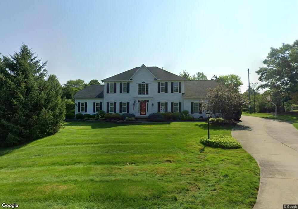
6727 Saint Regis Blvd Hudson, OH 44236
Estimated Value: $557,857 - $673,000
3
Beds
3
Baths
2,718
Sq Ft
$228/Sq Ft
Est. Value
About This Home
This home is located at 6727 Saint Regis Blvd, Hudson, OH 44236 and is currently estimated at $619,464, approximately $227 per square foot. 6727 Saint Regis Blvd is a home located in Summit County with nearby schools including Ellsworth Hill Elementary School, East Woods Intermediate School, and Hudson Middle School.
Ownership History
Date
Name
Owned For
Owner Type
Purchase Details
Closed on
Oct 26, 2010
Sold by
Marconi David A and Marconi Sandra
Bought by
Marconi David A and Marconi Sandra
Current Estimated Value
Purchase Details
Closed on
Oct 12, 2010
Sold by
Marconi David A and Marconi Sandra M
Bought by
Marconi David A and Marconi Sandra
Create a Home Valuation Report for This Property
The Home Valuation Report is an in-depth analysis detailing your home's value as well as a comparison with similar homes in the area
Home Values in the Area
Average Home Value in this Area
Purchase History
| Date | Buyer | Sale Price | Title Company |
|---|---|---|---|
| Marconi David A | -- | Attorney | |
| Marconi David A | -- | Attorney | |
| Marconi David A | -- | Attorney |
Source: Public Records
Tax History Compared to Growth
Tax History
| Year | Tax Paid | Tax Assessment Tax Assessment Total Assessment is a certain percentage of the fair market value that is determined by local assessors to be the total taxable value of land and additions on the property. | Land | Improvement |
|---|---|---|---|---|
| 2025 | $8,692 | $155,750 | $33,278 | $122,472 |
| 2024 | $8,692 | $179,165 | $33,278 | $145,887 |
| 2023 | $8,692 | $179,165 | $33,278 | $145,887 |
| 2022 | $7,531 | $140,000 | $28,203 | $111,797 |
| 2021 | $6,922 | $140,000 | $28,203 | $111,797 |
| 2020 | $8,073 | $151,920 | $28,200 | $123,720 |
| 2019 | $7,225 | $127,180 | $31,020 | $96,160 |
| 2018 | $7,200 | $127,180 | $31,020 | $96,160 |
| 2017 | $6,299 | $127,180 | $31,020 | $96,160 |
| 2016 | $6,344 | $109,260 | $28,200 | $81,060 |
| 2015 | $6,299 | $109,260 | $28,200 | $81,060 |
| 2014 | $6,317 | $109,260 | $28,200 | $81,060 |
| 2013 | $6,420 | $108,540 | $28,200 | $80,340 |
Source: Public Records
Map
Nearby Homes
- 139 Mccracken Rd
- 6167 Burr Oak Way
- 9085 Sandpiper Dr
- 9005 Sandpiper Dr
- 9011 Wood Thursh
- 8929 Falcon Dr
- 701 Gold Leaf Ct
- 9381 Hickory Ridge Dr
- 792 State Route 303
- 939 State Route 303
- 572 David Dr
- 10252 Wellman Rd Unit 8
- 708 Diane Ave
- 9251 Chestnut Ct
- 9247 Chestnut Ct
- 1011 Ashwood Ln
- 1013 Ashwood Ln
- 7449 Hudson Park Dr
- 150 Aurora St
- 5890 Eastham Way
- 6741 Saint Regis Blvd
- 6726 Saint Regis Blvd
- 6759 Saint Regis Blvd
- 6742 Saint Regis Blvd
- 6758 Saint Regis Blvd
- 6769 Saint Regis Blvd
- 6766 Saint Regis Blvd
- 2770 E Streetsboro Rd
- 2851 E Streetsboro Rd
- 2810 E Streetsboro Rd
- 6700 Stone Rd
- 2762 E Streetsboro Rd
- 2788 E Streetsboro Rd
- 6775 Saint Ives Blvd
- 6779 Saint Regis Blvd
- 2754 E Streetsboro Rd
- 2741 Last Valley Ln
- 6774 Saint Ives Blvd
- 6661 Meadow Farm Dr
- 6666 Stone Rd