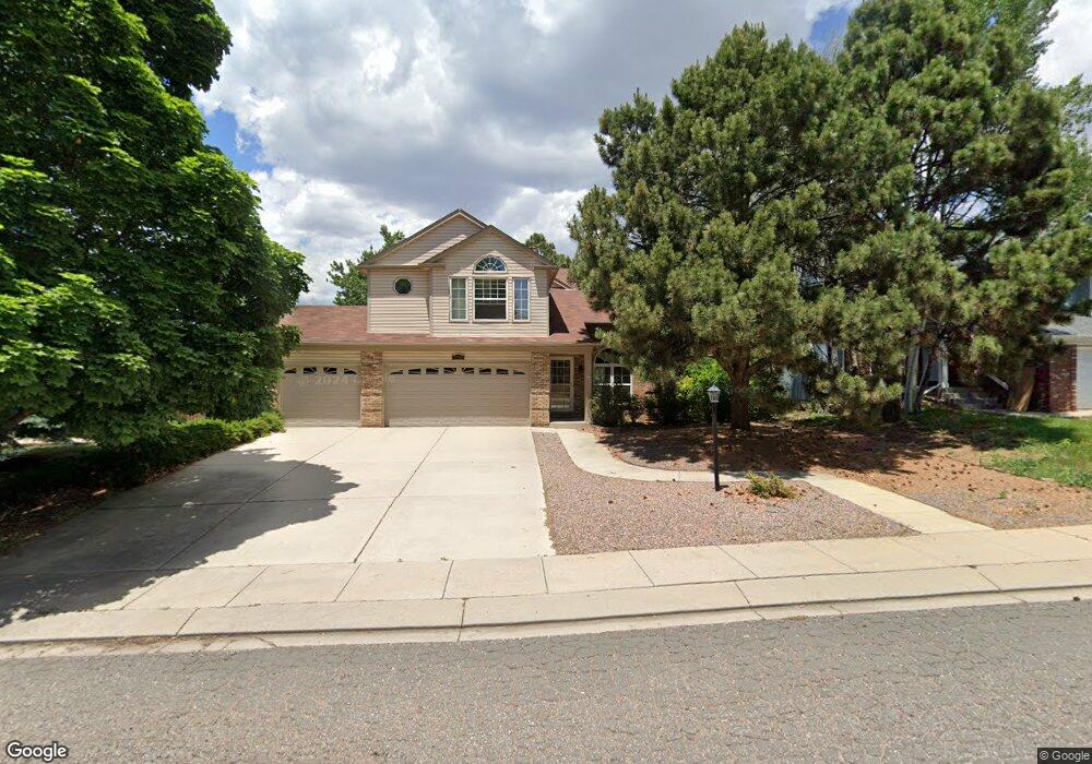
6730 Holt Dr Colorado Springs, CO 80922
Springs Ranch NeighborhoodEstimated Value: $452,097 - $477,000
3
Beds
4
Baths
1,715
Sq Ft
$274/Sq Ft
Est. Value
About This Home
This home is located at 6730 Holt Dr, Colorado Springs, CO 80922 and is currently estimated at $470,024, approximately $274 per square foot. 6730 Holt Dr is a home located in El Paso County with nearby schools including Springs Ranch Elementary School, Horizon Middle School, and Sand Creek High School.
Ownership History
Date
Name
Owned For
Owner Type
Purchase Details
Closed on
Oct 6, 1994
Sold by
Murphy R Dean
Bought by
Murphy R Dean and Murphy Laura L
Current Estimated Value
Purchase Details
Closed on
Jun 28, 1994
Sold by
Babcock Steven L
Bought by
Murphy R Dean
Home Financials for this Owner
Home Financials are based on the most recent Mortgage that was taken out on this home.
Original Mortgage
$124,233
Interest Rate
8.46%
Mortgage Type
FHA
Purchase Details
Closed on
May 21, 1992
Bought by
Murphy R Dean R and Murphy Laura L
Purchase Details
Closed on
Feb 28, 1990
Bought by
Murphy R Dean R and Murphy Laura L
Purchase Details
Closed on
Oct 1, 1989
Bought by
Murphy R Dean R and Murphy Laura L
Purchase Details
Closed on
Feb 1, 1989
Bought by
Murphy R Dean R and Murphy Laura L
Purchase Details
Closed on
Sep 1, 1987
Bought by
Murphy R Dean R and Murphy Laura L
Create a Home Valuation Report for This Property
The Home Valuation Report is an in-depth analysis detailing your home's value as well as a comparison with similar homes in the area
Home Values in the Area
Average Home Value in this Area
Purchase History
| Date | Buyer | Sale Price | Title Company |
|---|---|---|---|
| Murphy R Dean | -- | Land Title | |
| Murphy R Dean | $128,000 | First American | |
| Murphy R Dean R | -- | -- | |
| Murphy R Dean R | $95,000 | -- | |
| Murphy R Dean R | -- | -- | |
| Murphy R Dean R | -- | -- | |
| Murphy R Dean R | -- | -- |
Source: Public Records
Mortgage History
| Date | Status | Borrower | Loan Amount |
|---|---|---|---|
| Previous Owner | Murphy R Dean | $124,233 |
Source: Public Records
Tax History Compared to Growth
Tax History
| Year | Tax Paid | Tax Assessment Tax Assessment Total Assessment is a certain percentage of the fair market value that is determined by local assessors to be the total taxable value of land and additions on the property. | Land | Improvement |
|---|---|---|---|---|
| 2025 | $1,796 | $32,290 | -- | -- |
| 2024 | $1,697 | $32,230 | $4,620 | $27,610 |
| 2023 | $1,697 | $32,230 | $4,620 | $27,610 |
| 2022 | $1,433 | $23,060 | $4,170 | $18,890 |
| 2021 | $1,493 | $23,730 | $4,290 | $19,440 |
| 2020 | $1,285 | $20,190 | $3,580 | $16,610 |
| 2019 | $1,272 | $20,190 | $3,580 | $16,610 |
| 2018 | $1,085 | $16,900 | $3,020 | $13,880 |
| 2017 | $1,090 | $16,900 | $3,020 | $13,880 |
| 2016 | $1,078 | $16,490 | $2,950 | $13,540 |
| 2015 | $1,079 | $16,490 | $2,950 | $13,540 |
| 2014 | $952 | $14,280 | $2,790 | $11,490 |
Source: Public Records
Map
Nearby Homes
- 6835 Ashley Dr
- 6615 Annanhill Place
- 5914 Instone Cir
- 4611 Hotspur Dr
- 6980 Ashley Dr
- 5934 Instone Cir
- 6984 Ash Creek Heights Unit 204
- 7004 Ash Creek Heights Unit 201
- 4690 Badlands Ct
- 7084 Ash Creek Heights Unit 201
- 6180 Kettle Ct
- 7104 Ash Creek Heights Unit 203
- 6385 Boscomb Place
- 4354 Round Hill Dr
- 6125 Lowlander Ct
- 6330 Emma Ln
- 4240 Tee Shot Dr
- 6170 Katy Ct
- 5053 Blackcloud Loop
- 7020 Hillbeck Dr