Estimated Value: $54,455 - $118,000
--
Bed
1
Bath
1,064
Sq Ft
$85/Sq Ft
Est. Value
About This Home
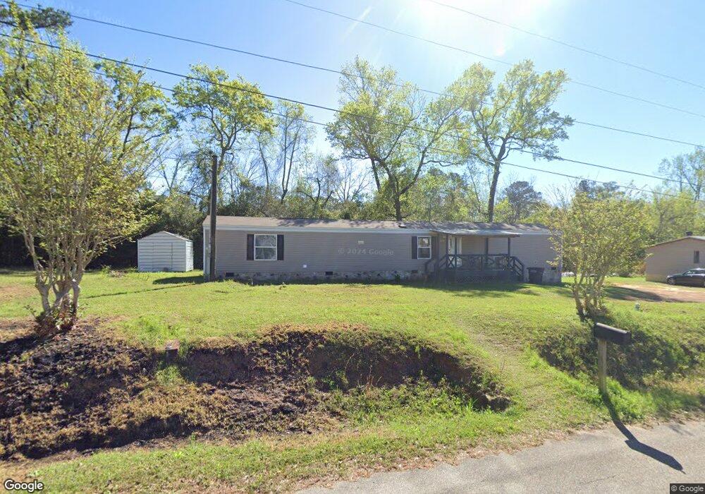
This home is located at 675 16th St SW, Cairo, GA 39828 and is currently estimated at $90,614, approximately $85 per square foot. 675 16th St SW is a home located in Grady County with nearby schools including Cairo High School.
Ownership History
Date
Name
Owned For
Owner Type
Purchase Details
Closed on
Jan 10, 2024
Sold by
Onesimus & Alice Properties Llc
Bought by
Corker Isaac Sue Alice
Current Estimated Value
Purchase Details
Closed on
Feb 6, 2018
Sold by
Ebanks Parks Shakira
Purchase Details
Closed on
Jun 26, 2009
Sold by
Cole Telisa Corker
Bought by
Parks Shakira Ebanks and Cole Emmanuel
Purchase Details
Closed on
Apr 24, 2009
Sold by
Durden Vera
Bought by
Corker Cole Telisa and Verda Durden Estate
Purchase Details
Closed on
Apr 23, 2009
Sold by
Corker Myrtice
Bought by
Cole Telisa Corker
Purchase Details
Closed on
Jul 3, 2007
Sold by
Corker Cole Telisa
Bought by
Corker Myrtice A
Purchase Details
Closed on
Aug 8, 1973
Bought by
Durden Vera Atkinson
Create a Home Valuation Report for This Property
The Home Valuation Report is an in-depth analysis detailing your home's value as well as a comparison with similar homes in the area
Home Values in the Area
Average Home Value in this Area
Purchase History
| Date | Buyer | Sale Price | Title Company |
|---|---|---|---|
| Corker Isaac Sue Alice | $7,575 | -- | |
| -- | $2,364 | -- | |
| Parks Shakira Ebanks | -- | -- | |
| Corker Cole Telisa | -- | -- | |
| Cole Telisa Corker | -- | -- | |
| Corker Myrtice A | -- | -- | |
| Durden Vera Atkinson | -- | -- |
Source: Public Records
Tax History Compared to Growth
Tax History
| Year | Tax Paid | Tax Assessment Tax Assessment Total Assessment is a certain percentage of the fair market value that is determined by local assessors to be the total taxable value of land and additions on the property. | Land | Improvement |
|---|---|---|---|---|
| 2024 | $149 | $3,783 | $2,500 | $1,283 |
| 2023 | $86 | $2,321 | $2,020 | $301 |
| 2022 | $78 | $2,020 | $2,020 | $0 |
| 2021 | $78 | $2,020 | $2,020 | $0 |
| 2020 | $78 | $2,020 | $2,020 | $0 |
| 2019 | $86 | $2,220 | $2,020 | $200 |
| 2018 | $82 | $2,220 | $2,020 | $200 |
| 2017 | $270 | $2,220 | $2,020 | $200 |
| 2016 | $80 | $2,220 | $2,020 | $200 |
| 2015 | $80 | $2,220 | $2,020 | $200 |
| 2014 | $80 | $2,220 | $2,020 | $200 |
| 2013 | -- | $2,220 | $2,020 | $200 |
Source: Public Records
Map
Nearby Homes
- 490 13th St SW
- 425 8th St SW
- 000 1st Ave SW
- 786 Madison Ln
- 117 6th St SW
- 374 Wight Rd
- 460 2nd St SW
- 136 Pine Cir SW
- 112 Pine Cir SW
- 000 Hwy 111 South 20 59 Acres
- 117 Pine Cir SW
- 40 5th Ave SW
- 720 1st St SW
- 109 Oriac Ave SW
- 27 6th Ave SW
- 1003 Syrup Mill Creek Ln
- 1013 Syrup Mill Creek Ln
- 1002 Syrup Mill Creek Ln
- 000 S Broad St
- 1006 Syrup Mill Creek Ln
- 701 Legion Blvd SW
- 660 16th St SW
- 639 Legion Blvd SW
- 655 16th St SW
- 650 16th St SW
- 680 15th St SW
- 694 15th St SW
- 634 15th St SW
- 645 16th St SW
- 630 15th St SW
- 790 Legion Blvd SW
- 600 16th St SW
- 620 15th St SW
- 675 15th St SW
- 550 Legion Blvd SW
- 680 Westbrooks St SW
- 494 Westbrooks St SW
- 512 Legion Blvd SW
- 519 Westbrooks St SW
- 510 Legion Blvd SW