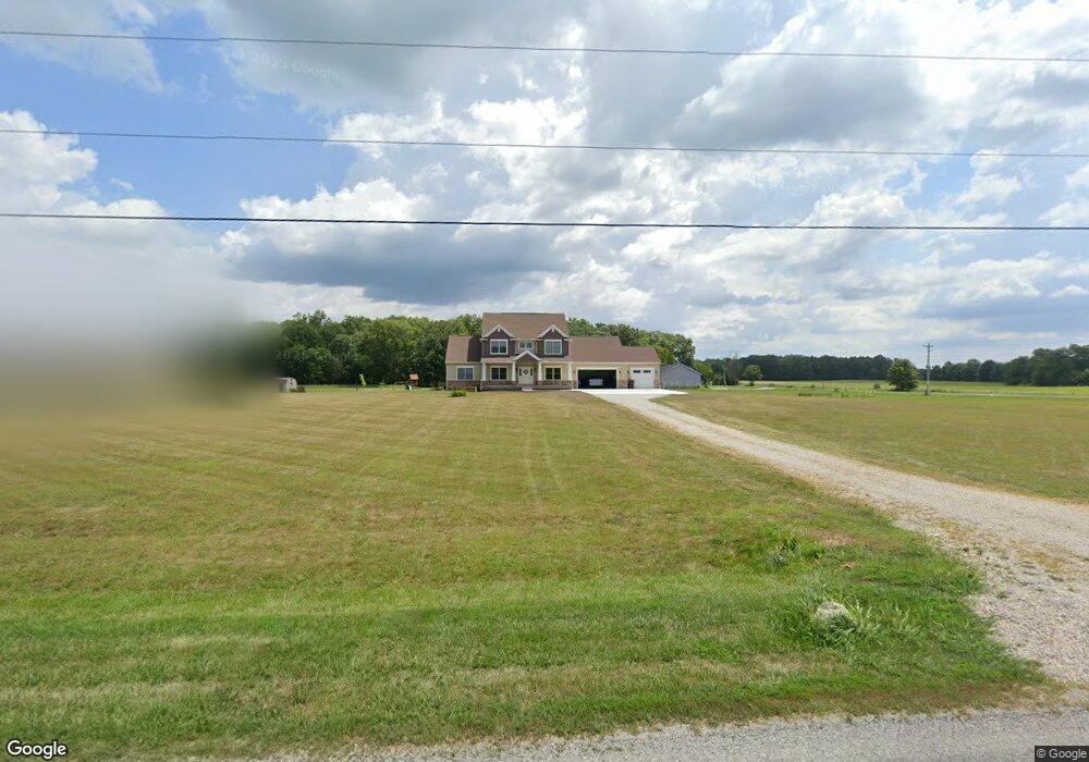
675 Brindle Rd Ostrander, OH 43061
Scioto NeighborhoodEstimated Value: $622,000 - $920,000
4
Beds
3
Baths
3,120
Sq Ft
$241/Sq Ft
Est. Value
About This Home
This home is located at 675 Brindle Rd, Ostrander, OH 43061 and is currently estimated at $753,143, approximately $241 per square foot. 675 Brindle Rd is a home with nearby schools including Buckeye Valley High School.
Ownership History
Date
Name
Owned For
Owner Type
Purchase Details
Closed on
May 20, 2017
Sold by
Sieger Brian M and Sieger Amanda
Bought by
Neff Joseph
Current Estimated Value
Purchase Details
Closed on
May 2, 2017
Sold by
Neff Joseph
Bought by
Sieger Brian M and Sieger Amanda
Purchase Details
Closed on
May 1, 2017
Sold by
Custodian Fbo James B Blumenstiel Ira
Bought by
Sieger Brian M and Sieger Amanda
Purchase Details
Closed on
Aug 4, 2016
Sold by
Blumenstiel James B and Equity Trust Company
Bought by
Sieger Brian and Sieger Amanda
Purchase Details
Closed on
Sep 28, 2010
Sold by
Blumenstiel James B and Huhn Richard M
Bought by
Equity Trust Company and James B Blumenstiel Ira
Create a Home Valuation Report for This Property
The Home Valuation Report is an in-depth analysis detailing your home's value as well as a comparison with similar homes in the area
Home Values in the Area
Average Home Value in this Area
Purchase History
| Date | Buyer | Sale Price | Title Company |
|---|---|---|---|
| Neff Joseph | -- | None Available | |
| Sieger Brian M | -- | None Available | |
| Sieger Brian M | $33,500 | None Available | |
| Sieger Brian | -- | Attorney | |
| Equity Trust Company | -- | Attorney |
Source: Public Records
Tax History
| Year | Tax Paid | Tax Assessment Tax Assessment Total Assessment is a certain percentage of the fair market value that is determined by local assessors to be the total taxable value of land and additions on the property. | Land | Improvement |
|---|---|---|---|---|
| 2024 | $7,101 | $214,590 | $30,770 | $183,820 |
| 2023 | $7,100 | $214,590 | $30,770 | $183,820 |
| 2022 | $5,437 | $146,340 | $22,470 | $123,870 |
| 2021 | $5,288 | $146,340 | $22,470 | $123,870 |
| 2020 | $5,319 | $146,340 | $22,470 | $123,870 |
| 2019 | $5,039 | $126,430 | $18,730 | $107,700 |
| 2018 | $5,131 | $126,430 | $18,730 | $107,700 |
| 2017 | $1,409 | $9,590 | $9,590 | $0 |
| 2016 | $1,340 | $9,590 | $9,590 | $0 |
| 2015 | $81 | $9,590 | $9,590 | $0 |
| 2014 | $76 | $9,590 | $9,590 | $0 |
| 2013 | $33 | $9,590 | $9,590 | $0 |
Source: Public Records
Map
Nearby Homes
- 0 Carr Rd Unit 225016840
- 6685 State Route 37 W
- 715 Tyler Rd
- 0 Burnt Pond Rd Unit Tract 2
- 0 Burnt Pond Rd Unit Tract 4
- 0 Burnt Pond Rd Unit Tract 5
- 1817 Lawrence Rd
- 535 Brayshaw Dr
- 9485 State Route 37
- 3480 Ostrander Rd
- 20478 Delaware County Line Rd
- 0 Delaware County Line Rd
- 231 Bluegrass Way
- 311 Ben Curtis Dr
- 3734 Warrensburg Rd
- 187 Long Trail
- 3680 Warrensburg Rd
- 0 Marsh Rd Unit 225031436
- 0 E High St Unit Tract 1 225034753
- 0 E High St Unit Tract 4 225034758
- 6810 Houseman Rd
- 661 Brindle Rd
- 6857 Houseman Rd
- 748 Brindle Rd
- 656 Brindle Rd
- 6724 Houseman Rd
- 6785 Houseman Rd
- 623 Brindle Rd
- 630 Brindle Rd
- 0 Brindle Rd Unit Tract 2 219032537
- 0 Brindle Rd Unit 11686
- 0 Brindle Rd Unit 11689
- 0 Brindle Rd Unit Trac5 2443328
- 0 Brindle Rd Unit Trac7 2443331
- 0 Brindle Rd Unit Tr7 2612212
- 0 Brindle Rd Unit Lot4 2421096
- 0 Brindle Rd Unit Lot1 2421080
- 0 Brindle Rd Unit Tr7 2542076
- 0 Brindle Rd Unit Tr5 2541914
- 0 Brindle Rd Unit Trac6 2443329
Your Personal Tour Guide
Ask me questions while you tour the home.