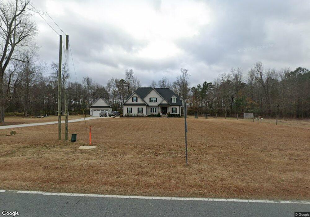
675 Gordon Rd Clayton, NC 27520
Estimated Value: $494,000 - $842,810
4
Beds
3
Baths
2,939
Sq Ft
$205/Sq Ft
Est. Value
About This Home
This home is located at 675 Gordon Rd, Clayton, NC 27520 and is currently estimated at $603,203, approximately $205 per square foot. 675 Gordon Rd is a home located in Johnston County with nearby schools including Riverwood Middle School, Clayton High, and American Leadership Academy.
Ownership History
Date
Name
Owned For
Owner Type
Purchase Details
Closed on
Jun 22, 2015
Sold by
Crosswind Custom Homes Inc
Bought by
Parker Garland C and Parker Emily P
Current Estimated Value
Home Financials for this Owner
Home Financials are based on the most recent Mortgage that was taken out on this home.
Original Mortgage
$474,500
Outstanding Balance
$371,789
Interest Rate
4.08%
Mortgage Type
New Conventional
Estimated Equity
$231,414
Create a Home Valuation Report for This Property
The Home Valuation Report is an in-depth analysis detailing your home's value as well as a comparison with similar homes in the area
Home Values in the Area
Average Home Value in this Area
Purchase History
| Date | Buyer | Sale Price | Title Company |
|---|---|---|---|
| Parker Garland C | $528,000 | None Available |
Source: Public Records
Mortgage History
| Date | Status | Borrower | Loan Amount |
|---|---|---|---|
| Open | Parker Garland C | $474,500 |
Source: Public Records
Tax History Compared to Growth
Tax History
| Year | Tax Paid | Tax Assessment Tax Assessment Total Assessment is a certain percentage of the fair market value that is determined by local assessors to be the total taxable value of land and additions on the property. | Land | Improvement |
|---|---|---|---|---|
| 2025 | $4,697 | $726,150 | $220,690 | $505,460 |
| 2024 | $3,621 | $433,520 | $91,340 | $342,180 |
| 2023 | $3,442 | $433,520 | $91,340 | $342,180 |
| 2022 | $3,543 | $433,520 | $91,340 | $342,180 |
| 2021 | $3,532 | $433,520 | $91,340 | $342,180 |
| 2020 | $3,670 | $433,520 | $91,340 | $342,180 |
| 2019 | $3,699 | $433,520 | $91,340 | $342,180 |
| 2018 | $3,348 | $383,200 | $80,460 | $302,740 |
| 2017 | $3,372 | $383,200 | $80,460 | $302,740 |
| 2016 | $3,219 | $383,200 | $80,460 | $302,740 |
| 2015 | -- | $58,770 | $58,770 | $0 |
Source: Public Records
Map
Nearby Homes
- 152 Poplar Dr
- 117 Poplar Dr
- 273 Stone Valley Ln
- 109 Hewitt Woods Dr
- 265 Stone Valley Ln
- 242 Flagstone Way
- 236 Flagstone Way
- 81 Hewitt Woods Dr
- 72 Hewitt Woods Dr
- 260 Wilson Farm Ln
- 102 Pear Tree Ln
- 118 Barley Field Dr
- 124 Barley Field Dr
- 130 Barley Field Dr
- 108 N Stonemill Trail Unit Homesite 254
- 111 S Rose Hill Dr
- 224 S Harvest Ridge Way
- Leland Plan at Crescent Mills - Single Family
- Craven Plan at Crescent Mills - Single Family
- Lenoir Plan at Crescent Mills - Single Family
- 675 Gordon Rd
- 675 Gordon Rd
- 675 Gordon Rd Unit 2
- 675 Gordon Rd Unit 3
- 675 Gordon Rd Unit 4
- 11 Ellas Ln
- 595 Gordon Rd
- 23 Ellas Ln
- 23 Brandywood Dr
- 23 Brandywood Dr Unit 1
- 35 Ellas Ln
- 12 Ellas Ln
- 551 Gordon Rd
- 34 Ellas Ln
- 75 Brandywood Dr
- 39 Ellas Ln
- 53 Brandywood Dr
- 97 Brandywood Dr
- 121 Brandywood Dr
- 121 Brandywood Dr Unit 5