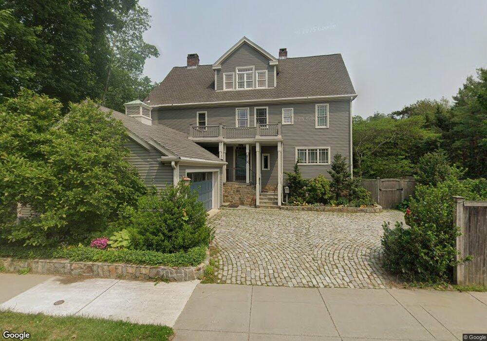
676 Hammond St Chestnut Hill, MA 02467
Chestnut Hill NeighborhoodEstimated Value: $2,634,280 - $2,928,000
5
Beds
5
Baths
4,024
Sq Ft
$687/Sq Ft
Est. Value
About This Home
This home is located at 676 Hammond St, Chestnut Hill, MA 02467 and is currently estimated at $2,764,820, approximately $687 per square foot. 676 Hammond St is a home located in Norfolk County with nearby schools including Baker School, Mount Alvernia Academy, and Brimmer & May School.
Ownership History
Date
Name
Owned For
Owner Type
Purchase Details
Closed on
Aug 2, 1993
Sold by
Moody Joann
Bought by
Joseph Hugh M
Current Estimated Value
Create a Home Valuation Report for This Property
The Home Valuation Report is an in-depth analysis detailing your home's value as well as a comparison with similar homes in the area
Home Values in the Area
Average Home Value in this Area
Purchase History
| Date | Buyer | Sale Price | Title Company |
|---|---|---|---|
| Joseph Hugh M | $338,300 | -- |
Source: Public Records
Mortgage History
| Date | Status | Borrower | Loan Amount |
|---|---|---|---|
| Open | Joseph Hugh M | $417,000 | |
| Closed | Joseph Hugh M | $394,026 |
Source: Public Records
Tax History Compared to Growth
Tax History
| Year | Tax Paid | Tax Assessment Tax Assessment Total Assessment is a certain percentage of the fair market value that is determined by local assessors to be the total taxable value of land and additions on the property. | Land | Improvement |
|---|---|---|---|---|
| 2025 | $22,512 | $2,280,900 | $975,000 | $1,305,900 |
| 2024 | $21,457 | $2,196,200 | $937,500 | $1,258,700 |
| 2023 | $20,094 | $2,015,400 | $781,300 | $1,234,100 |
| 2022 | $19,559 | $1,919,400 | $744,100 | $1,175,300 |
| 2021 | $18,087 | $1,845,600 | $715,500 | $1,130,100 |
| 2020 | $16,680 | $1,765,100 | $650,500 | $1,114,600 |
| 2019 | $15,751 | $1,681,000 | $619,500 | $1,061,500 |
| 2018 | $15,539 | $1,642,600 | $618,000 | $1,024,600 |
| 2017 | $15,382 | $1,556,900 | $583,000 | $973,900 |
| 2016 | $15,150 | $1,453,900 | $544,800 | $909,100 |
| 2015 | $14,512 | $1,358,800 | $509,200 | $849,600 |
| 2014 | $14,793 | $1,298,800 | $468,200 | $830,600 |
Source: Public Records
Map
Nearby Homes
- 3 Glenoe Rd
- 0 Glenoe Rd
- 76 Norfolk Rd
- 15 Glenland Rd
- 138 Woodland Rd
- 11 Hammond Pond Pkwy Unit 3
- 335 Heath St
- 1014 Boylston St
- 321 Hammond Pond Pkwy Unit 103
- 321 Hammond Pond Pkwy Unit 301
- 33 Hammond Pond Pkwy Unit 2
- 771 Heath St Unit 771
- 809-811 Heath St Unit 811
- 799 Heath St Unit 2
- 811 Heath St
- 174 Middlesex Rd
- 5 Heathwood Ln
- 130 Cabot St
- 142 Crafts Rd
- 85 Gate House Rd
- 675 Hammond St Unit 1
- 675 Hammond St Unit 2
- 675 Hammond St
- 675 Hammond St Unit 3 675
- 671 Hammond St
- 671 Hammond St Unit 2,671
- 671 Hammond St Unit 2
- 671 Hammond St Unit 1
- 683 Hammond St Unit B
- 683 Hammond St Unit A
- 683 Hammond St Unit B
- 665 Hammond St
- 665 Hammond St Unit 2
- 675 Hammond St Unit 2
- 675A Hammond St
- 681 Hammond St
- 681 Hammond St Unit A
- 681 Hammond St Unit B
- 661 Hammond St
- 687 Hammond St