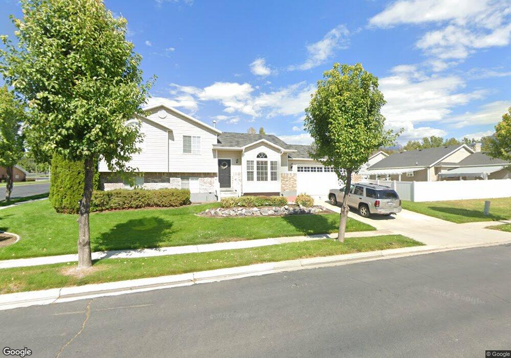
676 W 500 N American Fork, UT 84003
Estimated Value: $541,000 - $591,000
4
Beds
3
Baths
2,296
Sq Ft
$248/Sq Ft
Est. Value
About This Home
This home is located at 676 W 500 N, American Fork, UT 84003 and is currently estimated at $568,505, approximately $247 per square foot. 676 W 500 N is a home located in Utah County with nearby schools including Shelley Elementary School, American Fork Junior High School, and American Fork High School.
Ownership History
Date
Name
Owned For
Owner Type
Purchase Details
Closed on
May 25, 2018
Sold by
Smith Tharon L
Bought by
Olvera Sosa Jose Arturo
Current Estimated Value
Home Financials for this Owner
Home Financials are based on the most recent Mortgage that was taken out on this home.
Original Mortgage
$326,870
Outstanding Balance
$282,092
Interest Rate
4.5%
Mortgage Type
New Conventional
Estimated Equity
$286,413
Purchase Details
Closed on
May 27, 2016
Sold by
Norton Drew and Norton Lauralee
Bought by
Smith Tharon L
Home Financials for this Owner
Home Financials are based on the most recent Mortgage that was taken out on this home.
Original Mortgage
$260,000
Interest Rate
3.58%
Mortgage Type
New Conventional
Purchase Details
Closed on
Jun 1, 2009
Sold by
Oswald Lauralee
Bought by
Norton Drew and Norton Lauralee
Home Financials for this Owner
Home Financials are based on the most recent Mortgage that was taken out on this home.
Original Mortgage
$150,000
Interest Rate
4.78%
Mortgage Type
Purchase Money Mortgage
Purchase Details
Closed on
Aug 31, 2007
Sold by
Johnson Gregory Lloyd and Johnson Rebecca Peterson
Bought by
Oswald Lauralee
Home Financials for this Owner
Home Financials are based on the most recent Mortgage that was taken out on this home.
Original Mortgage
$150,000
Interest Rate
6.67%
Mortgage Type
New Conventional
Purchase Details
Closed on
Aug 15, 2006
Sold by
Waddoups Gregory L and Waddoups Jodi C
Bought by
Johnson Gregory Lloyd and Johnson Rebecca Peterson
Home Financials for this Owner
Home Financials are based on the most recent Mortgage that was taken out on this home.
Original Mortgage
$207,000
Interest Rate
6.76%
Mortgage Type
Purchase Money Mortgage
Purchase Details
Closed on
Dec 15, 1999
Sold by
D R Horton Inc
Bought by
Waddoups Gregory L and Waddoups Jodi C
Home Financials for this Owner
Home Financials are based on the most recent Mortgage that was taken out on this home.
Original Mortgage
$152,000
Interest Rate
7.82%
Create a Home Valuation Report for This Property
The Home Valuation Report is an in-depth analysis detailing your home's value as well as a comparison with similar homes in the area
Home Values in the Area
Average Home Value in this Area
Purchase History
| Date | Buyer | Sale Price | Title Company |
|---|---|---|---|
| Olvera Sosa Jose Arturo | -- | Vanguard Title Ins Agency Ll | |
| Smith Tharon L | -- | Meridian Title Co | |
| Norton Drew | -- | Premier Title Insurance Age | |
| Oswald Lauralee | -- | Inwest Title Services Inc | |
| Johnson Gregory Lloyd | -- | Inwest Title Services Inc | |
| Waddoups Gregory L | -- | First American Title Ins Co |
Source: Public Records
Mortgage History
| Date | Status | Borrower | Loan Amount |
|---|---|---|---|
| Open | Olvera Sosa Jose Arturo | $326,870 | |
| Previous Owner | Smith Tharon L | $260,000 | |
| Previous Owner | Norton Drew | $150,000 | |
| Previous Owner | Oswald Lauralee | $150,000 | |
| Previous Owner | Johnson Gregory Lloyd | $207,000 | |
| Previous Owner | Waddoups Gregory L | $152,000 |
Source: Public Records
Tax History Compared to Growth
Tax History
| Year | Tax Paid | Tax Assessment Tax Assessment Total Assessment is a certain percentage of the fair market value that is determined by local assessors to be the total taxable value of land and additions on the property. | Land | Improvement |
|---|---|---|---|---|
| 2025 | $2,401 | $291,995 | $214,800 | $316,100 |
| 2024 | $2,401 | $266,750 | $0 | $0 |
| 2023 | $2,252 | $265,265 | $0 | $0 |
| 2022 | $2,479 | $288,200 | $0 | $0 |
| 2021 | $2,125 | $385,900 | $154,100 | $231,800 |
| 2020 | $1,989 | $350,300 | $137,600 | $212,700 |
| 2019 | $1,774 | $323,100 | $127,300 | $195,800 |
| 2018 | $1,670 | $290,800 | $120,400 | $170,400 |
| 2017 | $1,589 | $149,380 | $0 | $0 |
| 2016 | $1,489 | $130,075 | $0 | $0 |
| 2015 | $1,451 | $120,230 | $0 | $0 |
| 2014 | $1,395 | $114,015 | $0 | $0 |
Source: Public Records
Map
Nearby Homes
- 777 W State Rd
- 962 N 780 St W Unit 508
- 974 N 780 St W Unit 509
- 916 N 780 St W Unit 501
- 641 N 420 W
- 356 N 480 W
- 822 W 800 St N Unit LOT319
- 822 N 860 W Unit 317
- 602 W 860 N
- 540 N 300 W
- 399 W Pacific Dr
- 370 W Pacific Dr Unit 1
- 914 N 400 W Unit A
- 901 N Lakota Rd
- 3935 W 1000 N Unit 438
- 3983 W 1000 N Unit 442
- 4007 W 1000 N
- 3947 W 1000 N Unit 439
- 3959 W 1000 N
- 987 N 410 W