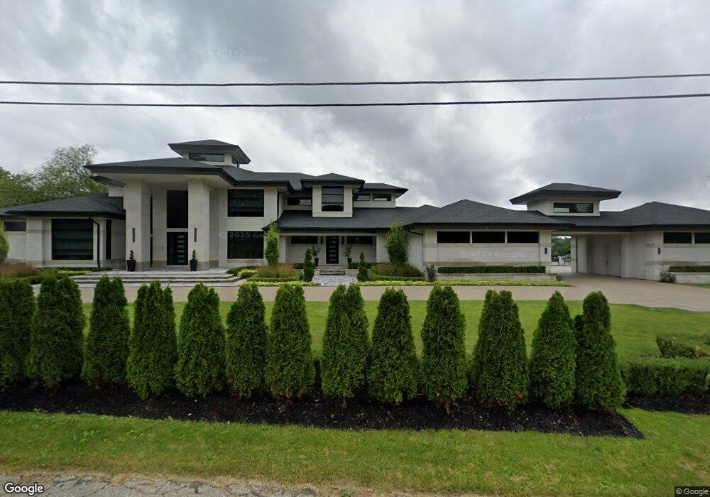
6765 Meadowlake Rd Unit Bldg-Unit Bloomfield Hills, MI 48301
Estimated Value: $1,337,000 - $3,583,000
6
Beds
7
Baths
7,821
Sq Ft
$323/Sq Ft
Est. Value
About This Home
This home is located at 6765 Meadowlake Rd Unit Bldg-Unit, Bloomfield Hills, MI 48301 and is currently estimated at $2,525,708, approximately $322 per square foot. 6765 Meadowlake Rd Unit Bldg-Unit is a home located in Oakland County with nearby schools including Wylie E. Groves High School, West Maple Elementary School, and Berkshire Middle School.
Ownership History
Date
Name
Owned For
Owner Type
Purchase Details
Closed on
Dec 29, 2021
Sold by
Spm Property Group Llc
Bought by
Grewal Baljit K and Grewal Pargat S
Current Estimated Value
Purchase Details
Closed on
Sep 14, 2018
Sold by
Kamil Leslie H and Kamil Lisa S
Bought by
Spm Property Group Llc
Purchase Details
Closed on
Jun 13, 2012
Sold by
Kamil Leslie H and June L Kamil Agreement Of Trus
Bought by
Kamil Leslie H and Kamil Lisa S
Purchase Details
Closed on
Apr 29, 2009
Sold by
Kamil June L
Bought by
Kamil June L and June L Kamil Restated Revocable Living T
Create a Home Valuation Report for This Property
The Home Valuation Report is an in-depth analysis detailing your home's value as well as a comparison with similar homes in the area
Home Values in the Area
Average Home Value in this Area
Purchase History
| Date | Buyer | Sale Price | Title Company |
|---|---|---|---|
| Grewal Baljit K | -- | None Listed On Document | |
| Spm Property Group Llc | -- | Ata National Title Group Llc | |
| Kamil Leslie H | -- | None Available | |
| Kamil June L | -- | None Available |
Source: Public Records
Tax History Compared to Growth
Tax History
| Year | Tax Paid | Tax Assessment Tax Assessment Total Assessment is a certain percentage of the fair market value that is determined by local assessors to be the total taxable value of land and additions on the property. | Land | Improvement |
|---|---|---|---|---|
| 2024 | $28,203 | $1,973,280 | $0 | $0 |
| 2023 | $27,065 | $1,703,920 | $0 | $0 |
| 2022 | $52,875 | $1,641,900 | $0 | $0 |
| 2021 | $23,993 | $475,000 | $0 | $0 |
| 2020 | $6,043 | $219,200 | $0 | $0 |
| 2019 | $11,358 | $219,200 | $0 | $0 |
| 2018 | $11,551 | $402,400 | $0 | $0 |
| 2017 | $11,544 | $395,400 | $0 | $0 |
| 2016 | $11,607 | $416,060 | $0 | $0 |
| 2015 | -- | $379,330 | $0 | $0 |
| 2014 | -- | $270,590 | $0 | $0 |
| 2011 | -- | $309,750 | $0 | $0 |
Source: Public Records
Map
Nearby Homes
- 6730 Halyard Rd
- 6940 Castle Dr
- 4665 W Maple Rd
- 6420 Apple Grove Ln Unit 10
- 6720 Castle Dr
- 6800 N Clunbury Rd
- 2014 Waldons Ct
- 4647 Private Lake Dr
- 2189 Colony Club Ct
- 7315 Lindenmere Dr
- 6701 Franklin Rd
- 7371 Lindenmere Dr
- 6041 Eastmoor Rd
- 4776 Walnut Lake Rd
- 27170 W 14 Mile Rd
- 4456 W Maple Rd
- 5897 Sutters Ln
- 7310 Sandy Creek Ln
- 4428 Old Trinity Ct
- 4603 Hedgewood Dr
- 6765 Meadowlake Rd
- 6735 Meadowlake Rd
- 6815 Meadowlake Rd
- 6721 Mark Ct
- 6705 Meadowlake Rd
- 6730 Meadowlake Rd
- 6796 Meadowlake Rd
- 6700 Meadowlake Rd
- 6815 Mark Ct
- 6845 Meadowlake Rd
- 6675 Meadowlake Rd
- 6780 Mark Ct
- 6712 Mark Ct
- 6700 Mark Ct
- 6840 Meadowlake Rd
- 6658 Meadowlake Rd
- 6820 Mark Ct
- 6865 Meadowlake Rd
- 6645 Meadowlake Rd
- 6695 Whysall Rd