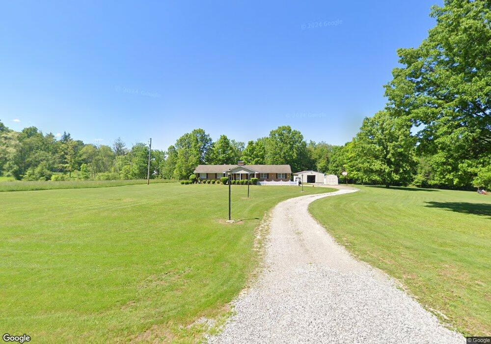
6766 E South Range Rd Petersburg, OH 44454
Estimated Value: $320,717 - $411,000
3
Beds
2
Baths
1,796
Sq Ft
$195/Sq Ft
Est. Value
About This Home
This home is located at 6766 E South Range Rd, Petersburg, OH 44454 and is currently estimated at $350,429, approximately $195 per square foot. 6766 E South Range Rd is a home located in Mahoning County with nearby schools including Springfield Elementary School, Springfield Intermediate Middle School, and Springfield High School.
Ownership History
Date
Name
Owned For
Owner Type
Purchase Details
Closed on
May 25, 2022
Bought by
Morrow Carrie A Truste
Current Estimated Value
Purchase Details
Closed on
May 23, 2022
Sold by
Ross Eugene T
Bought by
Eugene T Ross Family Trust and Morrow
Purchase Details
Closed on
Jul 24, 1978
Bought by
Ross Eugene T and Ross Sandra L
Create a Home Valuation Report for This Property
The Home Valuation Report is an in-depth analysis detailing your home's value as well as a comparison with similar homes in the area
Home Values in the Area
Average Home Value in this Area
Purchase History
| Date | Buyer | Sale Price | Title Company |
|---|---|---|---|
| Morrow Carrie A Truste | -- | -- | |
| Eugene T Ross Family Trust | -- | None Listed On Document | |
| Eugene T Ross Family Trust | -- | None Listed On Document | |
| Ross Eugene T | -- | None Listed On Document | |
| Ross Eugene T | -- | None Listed On Document | |
| Ross Eugene T | -- | -- |
Source: Public Records
Tax History Compared to Growth
Tax History
| Year | Tax Paid | Tax Assessment Tax Assessment Total Assessment is a certain percentage of the fair market value that is determined by local assessors to be the total taxable value of land and additions on the property. | Land | Improvement |
|---|---|---|---|---|
| 2024 | $3,175 | $88,340 | $8,460 | $79,880 |
| 2023 | $3,147 | $88,340 | $8,460 | $79,880 |
| 2022 | $2,724 | $70,220 | $8,460 | $61,760 |
| 2021 | $2,744 | $70,220 | $8,460 | $61,760 |
| 2020 | $2,759 | $70,220 | $8,460 | $61,760 |
| 2019 | $2,508 | $62,640 | $8,460 | $54,180 |
| 2018 | $2,476 | $62,640 | $8,460 | $54,180 |
| 2017 | $2,473 | $62,640 | $8,460 | $54,180 |
| 2016 | $2,215 | $56,450 | $7,670 | $48,780 |
| 2015 | $2,156 | $56,450 | $7,670 | $48,780 |
| 2014 | $2,166 | $56,450 | $7,670 | $48,780 |
| 2013 | $2,145 | $56,450 | $7,670 | $48,780 |
Source: Public Records
Map
Nearby Homes
- 6338 E South Range Rd
- 11.61 acres Stateline Rd
- 151 Crum Rd
- 5589 Middletown Rd E
- 5272 Middletown Rd E
- 10901 Main St
- 9 W Fairview Ave
- 817 S Main St
- 537 S Main St
- 42 Sycamore Dr
- 0 Youngstown - Pittsburgh Rd Unit 5110475
- 8 Elm St
- 2 Sandy Dr
- 9897 Struthers Rd
- 0 Meadowbrook Dr Unit 5110501
- 5541 E Calla Rd
- 4940 E Calla Rd
- 170 Sandy Ct Unit 11
- 0 Sandy Ct Unit 5110511
- 10115 Carrie Ct
- 6690 E South Range Rd
- 6807 E South Range Rd
- 6846 E South Range Rd
- 6706 E South Range Rd
- 6759 E South Range Rd
- 6803 E South Range Rd
- 6783 E South Range Rd
- 6862 E South Range Rd
- 6805 E South Range Rd
- 6685 E South Range Rd
- 6855 E South Range Rd
- 6954 E South Range Rd
- 12140 S State Line Rd
- 6980 E South Range Rd
- 6565 E South Range Rd
- 6582 E South Range Rd
- 6540 E South Range Rd
- 503 Stateline Rd
- 513 Stateline Rd
- 6510 E South Range Rd