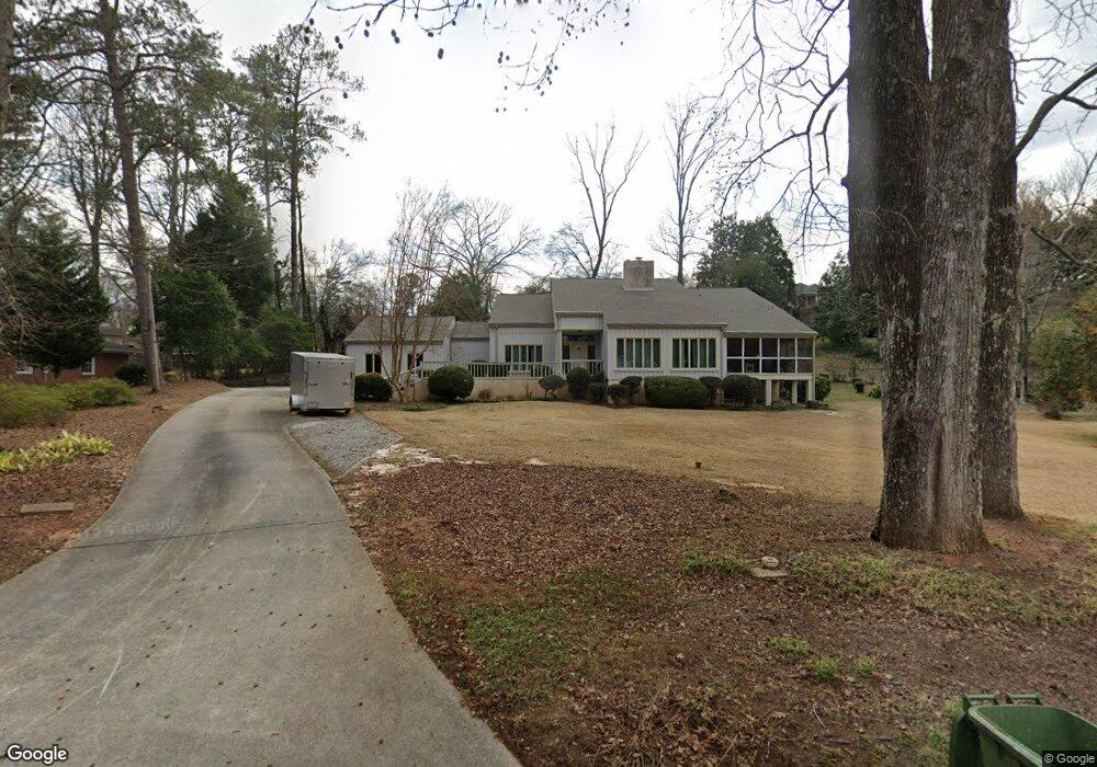
677 Brook Cir Griffin, GA 30224
Spalding County NeighborhoodEstimated Value: $447,000 - $552,000
5
Beds
5
Baths
4,191
Sq Ft
$122/Sq Ft
Est. Value
About This Home
This home is located at 677 Brook Cir, Griffin, GA 30224 and is currently estimated at $512,451, approximately $122 per square foot. 677 Brook Cir is a home located in Spalding County with nearby schools including Futral Road Elementary School, Rehoboth Road Middle School, and Spalding High School.
Ownership History
Date
Name
Owned For
Owner Type
Purchase Details
Closed on
Jan 27, 2021
Sold by
Colwell Dawn Taylor
Bought by
Fletcher Jon Richard and Fletcher Julia Smith
Current Estimated Value
Home Financials for this Owner
Home Financials are based on the most recent Mortgage that was taken out on this home.
Original Mortgage
$189,000
Outstanding Balance
$108,438
Interest Rate
2.6%
Mortgage Type
Commercial
Estimated Equity
$404,013
Purchase Details
Closed on
Feb 1, 2008
Sold by
Knight Annette S
Bought by
Taylor Dawn L and Colwell Gregory
Home Financials for this Owner
Home Financials are based on the most recent Mortgage that was taken out on this home.
Original Mortgage
$265,600
Interest Rate
6.12%
Mortgage Type
New Conventional
Purchase Details
Closed on
Jun 13, 1997
Sold by
Baggett Martin A and Baggett Kaye H
Bought by
Knight Annette S
Purchase Details
Closed on
Apr 23, 1992
Sold by
Rich Joseph Edward
Bought by
Baggett Martin Alan and Baggett Kay H
Purchase Details
Closed on
Mar 14, 1991
Sold by
Furlow Furlow T and Furlow Margaret B
Bought by
Rich Joseph Edward
Purchase Details
Closed on
Jan 1, 1977
Sold by
Cheatham Leilan Grantland
Bought by
Furlow Furlow T and Furlow Margaret B
Purchase Details
Closed on
Dec 6, 1976
Sold by
Cheatham Mrs Leila Barnes
Bought by
Cheatham Leila Grantland Etal
Purchase Details
Closed on
Dec 22, 1952
Bought by
Cheatham Mrs Leila Barnes
Create a Home Valuation Report for This Property
The Home Valuation Report is an in-depth analysis detailing your home's value as well as a comparison with similar homes in the area
Home Values in the Area
Average Home Value in this Area
Purchase History
| Date | Buyer | Sale Price | Title Company |
|---|---|---|---|
| Fletcher Jon Richard | $347,000 | -- | |
| Taylor Dawn L | $380,000 | -- | |
| Knight Annette S | $237,500 | -- | |
| Baggett Martin Alan | $240,000 | -- | |
| Rich Joseph Edward | $240,000 | -- | |
| Furlow Furlow T | $10,500 | -- | |
| Cheatham Leila Grantland Etal | -- | -- | |
| Cheatham Mrs Leila Barnes | -- | -- |
Source: Public Records
Mortgage History
| Date | Status | Borrower | Loan Amount |
|---|---|---|---|
| Open | Fletcher Jon Richard | $189,000 | |
| Previous Owner | Taylor Dawn L | $265,600 |
Source: Public Records
Tax History Compared to Growth
Tax History
| Year | Tax Paid | Tax Assessment Tax Assessment Total Assessment is a certain percentage of the fair market value that is determined by local assessors to be the total taxable value of land and additions on the property. | Land | Improvement |
|---|---|---|---|---|
| 2024 | $6,301 | $167,329 | $20,000 | $147,329 |
| 2023 | $6,301 | $167,329 | $20,000 | $147,329 |
| 2022 | $5,547 | $148,365 | $20,000 | $128,365 |
| 2021 | $5,104 | $130,066 | $20,000 | $110,066 |
| 2020 | $5,104 | $130,066 | $20,000 | $110,066 |
| 2019 | $4,957 | $124,165 | $26,000 | $98,165 |
| 2018 | $4,882 | $117,934 | $26,000 | $91,934 |
| 2017 | $4,777 | $117,934 | $26,000 | $91,934 |
| 2016 | $4,854 | $117,934 | $26,000 | $91,934 |
| 2015 | $4,934 | $117,934 | $26,000 | $91,934 |
| 2014 | $5,082 | $117,934 | $26,000 | $91,934 |
Source: Public Records
Map
Nearby Homes
- 505 Kincaid Ave
- 821 Bel Air Cir
- 524 Kincaid Ave
- 304 Tilney Ave
- 831 Bel Air Cir
- 40 Terrace St
- 18 Terracedale Ct
- 818 Hillcrest Ave
- 706 Maple Dr
- 714 Maple Dr
- 108 Jackson Ln
- 512 Searcy Ave
- 523 S 6th St
- 406 E Solomon St
- 541 S 6th St
- 303 E Broadway St
- 134 Townsend Ct
- 203 N 1st St
- 550 S Hill St
- 650 S Hill St