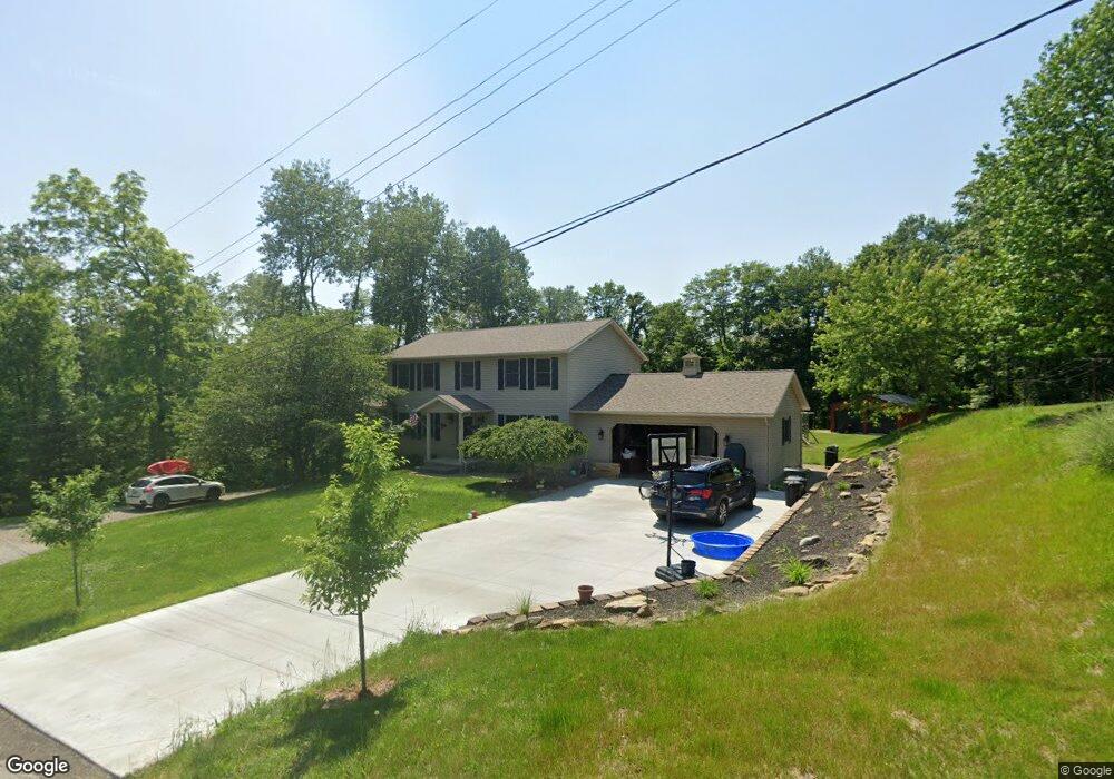
67701 Lofland Rd Cambridge, OH 43725
Estimated Value: $241,000 - $321,374
4
Beds
4
Baths
2,080
Sq Ft
$139/Sq Ft
Est. Value
About This Home
This home is located at 67701 Lofland Rd, Cambridge, OH 43725 and is currently estimated at $289,594, approximately $139 per square foot. 67701 Lofland Rd is a home located in Guernsey County with nearby schools including Cambridge High School.
Ownership History
Date
Name
Owned For
Owner Type
Purchase Details
Closed on
Nov 6, 2024
Sold by
Mullen Robert
Bought by
Mullen Robert and Mullen Holly Betty
Current Estimated Value
Home Financials for this Owner
Home Financials are based on the most recent Mortgage that was taken out on this home.
Original Mortgage
$433,200
Outstanding Balance
$428,887
Interest Rate
6.12%
Mortgage Type
New Conventional
Estimated Equity
-$139,293
Purchase Details
Closed on
Apr 5, 2018
Sold by
Preece Brent E and Preece Linda A
Bought by
Mullen Robert
Home Financials for this Owner
Home Financials are based on the most recent Mortgage that was taken out on this home.
Original Mortgage
$180,000
Interest Rate
4.46%
Mortgage Type
New Conventional
Create a Home Valuation Report for This Property
The Home Valuation Report is an in-depth analysis detailing your home's value as well as a comparison with similar homes in the area
Home Values in the Area
Average Home Value in this Area
Purchase History
| Date | Buyer | Sale Price | Title Company |
|---|---|---|---|
| Mullen Robert | -- | Valmer Land Title | |
| Mullen Robert | -- | Valmer Land Title | |
| Mullen Robert | -- | Valmer Land Title | |
| Mullen Robert | $200,000 | None Available |
Source: Public Records
Mortgage History
| Date | Status | Borrower | Loan Amount |
|---|---|---|---|
| Open | Mullen Robert | $433,200 | |
| Closed | Mullen Robert | $433,200 | |
| Previous Owner | Mullen Robert | $180,000 |
Source: Public Records
Tax History Compared to Growth
Tax History
| Year | Tax Paid | Tax Assessment Tax Assessment Total Assessment is a certain percentage of the fair market value that is determined by local assessors to be the total taxable value of land and additions on the property. | Land | Improvement |
|---|---|---|---|---|
| 2024 | $3,501 | $82,062 | $11,848 | $70,214 |
| 2023 | $3,501 | $65,786 | $9,401 | $56,385 |
| 2022 | $3,022 | $65,810 | $9,420 | $56,390 |
| 2021 | $2,989 | $65,810 | $9,420 | $56,390 |
| 2020 | $2,905 | $63,270 | $7,490 | $55,780 |
| 2019 | $2,870 | $63,270 | $7,490 | $55,780 |
| 2018 | $2,522 | $63,270 | $7,490 | $55,780 |
| 2017 | $2,414 | $54,820 | $6,510 | $48,310 |
| 2016 | $2,360 | $54,820 | $6,510 | $48,310 |
| 2015 | $2,360 | $54,820 | $6,510 | $48,310 |
| 2014 | -- | $51,660 | $5,290 | $46,370 |
| 2013 | $2,332 | $51,660 | $5,290 | $46,370 |
Source: Public Records
Map
Nearby Homes
- 67295 Old Twenty One Rd
- 67706 Oldham Rd
- 10909 Barrett Hill Rd
- 10909 Ruby Rd
- 10084 Cadiz Rd
- 1616 Quail Hollow Dr
- 0 Angus Rd
- 1355 Highland Ave
- 0 Pigeon Gap Rd
- 1121 Clark St
- 818 Highland Ave
- 66421 Wolfs Den Rd
- 808 N 12th St
- 812 N 12th St
- 807 Harrison Ave
- 632 N 9th St
- 614 N 11th St
- 614 N North 11th St
- 1515 Stewart Ave
- 620 N 9th St
- 67779 Lofland Rd
- 67600 Lofland Rd
- 67700 Lofland Rd
- 67803 Lofland Rd
- 67794 Lofland Rd
- 67827 Lofland Rd
- 67945 Lofland Rd
- 68004 Lofland Rd
- 68000 Lofland Rd
- 68001 Lofland Rd
- 67590 E Lofland Rd
- 68014 Lofland Rd
- 9220 Liberty Rd
- 67872 E Lofland Rd
- 9254 Liberty Rd
- 68002 Lofland Rd
- 9270 Liberty Rd
- 9300 Liberty Rd
- 67920 Old Twenty One Rd
- 68012 E Lofland Rd