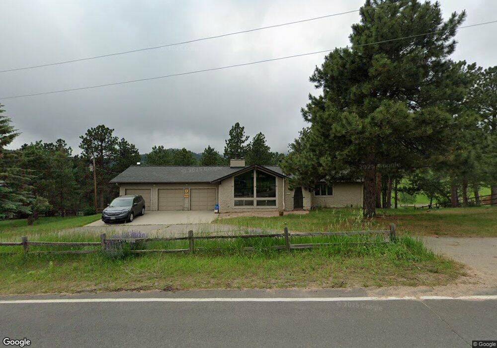
6777 High Dr Morrison, CO 80465
North Turkey Creek NeighborhoodEstimated Value: $884,000 - $1,079,000
3
Beds
2
Baths
2,698
Sq Ft
$348/Sq Ft
Est. Value
About This Home
This home is located at 6777 High Dr, Morrison, CO 80465 and is currently estimated at $939,307, approximately $348 per square foot. 6777 High Dr is a home located in Jefferson County with nearby schools including Marshdale Elementary School, West Jefferson Middle School, and Conifer Senior High School.
Ownership History
Date
Name
Owned For
Owner Type
Purchase Details
Closed on
Aug 13, 2018
Sold by
Peesel Robert Henry and Peesel April
Bought by
Runyon Brian and Pipal Jessica
Current Estimated Value
Home Financials for this Owner
Home Financials are based on the most recent Mortgage that was taken out on this home.
Original Mortgage
$477,200
Outstanding Balance
$414,429
Interest Rate
4.5%
Mortgage Type
New Conventional
Estimated Equity
$524,878
Purchase Details
Closed on
Oct 25, 2017
Sold by
Peesel Robert Herny and Peesel April Ann
Bought by
Peesel Robert Henry and April Ann Peesel R
Purchase Details
Closed on
Jun 12, 2015
Sold by
The John A Grover Trust
Bought by
Peesel April A and Peesel Robert H
Home Financials for this Owner
Home Financials are based on the most recent Mortgage that was taken out on this home.
Original Mortgage
$249,500
Interest Rate
3.7%
Mortgage Type
New Conventional
Purchase Details
Closed on
Aug 28, 2000
Sold by
Grover John A Grover Rita J
Bought by
The John A Grover Trust and The Rita J Grover Trust
Create a Home Valuation Report for This Property
The Home Valuation Report is an in-depth analysis detailing your home's value as well as a comparison with similar homes in the area
Home Values in the Area
Average Home Value in this Area
Purchase History
| Date | Buyer | Sale Price | Title Company |
|---|---|---|---|
| Runyon Brian | $596,500 | Land Title Guarantee Company | |
| Peesel Robert Henry | -- | None Available | |
| Peesel April A | $549,500 | Land Title Guarantee Company | |
| The John A Grover Trust | -- | -- |
Source: Public Records
Mortgage History
| Date | Status | Borrower | Loan Amount |
|---|---|---|---|
| Open | Runyon Brian | $477,200 | |
| Previous Owner | Peesel April A | $249,500 |
Source: Public Records
Tax History
| Year | Tax Paid | Tax Assessment Tax Assessment Total Assessment is a certain percentage of the fair market value that is determined by local assessors to be the total taxable value of land and additions on the property. | Land | Improvement |
|---|---|---|---|---|
| 2024 | $4,551 | $49,623 | $13,875 | $35,748 |
| 2023 | $4,551 | $49,623 | $13,875 | $35,748 |
| 2022 | $3,729 | $39,472 | $8,083 | $31,389 |
| 2021 | $3,768 | $40,608 | $8,316 | $32,292 |
| 2020 | $3,462 | $37,021 | $7,141 | $29,880 |
| 2019 | $3,413 | $37,021 | $7,141 | $29,880 |
| 2018 | $3,106 | $32,581 | $6,352 | $26,229 |
| 2017 | $2,828 | $32,581 | $6,352 | $26,229 |
| 2016 | $2,560 | $27,565 | $7,211 | $20,354 |
| 2015 | $1,435 | $27,565 | $7,211 | $20,354 |
| 2014 | $1,435 | $22,957 | $7,610 | $15,347 |
Source: Public Records
Map
Nearby Homes
- 22354 Park Ln
- 6616 High Dr
- 7307 S Settlers Dr
- 7262 S Sourdough Dr
- 6530 Ridgeview Dr
- 6387 High Dr
- 22056 High Spring Trail
- 21965 High Springs Trail
- 7552 Surrey Dr
- 8001 S Homesteader Dr
- 6498 S Turkey Creek Rd
- 8036 Settlers Dr
- 8111 S Homesteader Dr
- 5704 Santa Clara Rd
- 8045 S Wagon Wheel Rd
- 7438 S Turkey Creek Rd
- 8066 Federation Dr
- 8220 Iowa Gulch Rd
- 7033 Silverhorn Dr
- 22296 Cook Ln
- 6787 High Dr
- 6767 High Dr
- 6797 High Dr
- 6766 High Dr
- 0 High Dr & Valley Dr
- 6783 S Valley Dr
- 6757 High Dr
- 0 038706 Unit 5703420
- 21948 Plateau Cir
- 6955 Plateau Ln
- 6954 Plateau Ln
- 6945 Plateau Ln
- 21969 Plateau Cir
- 21929 Plateau Cir
- 6753 S Valley Dr
- 21860 Rinconada Rd
- 21939 Plateau Cir
- 21482 Twin Peaks Ln
- 21968 Plateau Cir
- 6837 High Dr
Your Personal Tour Guide
Ask me questions while you tour the home.