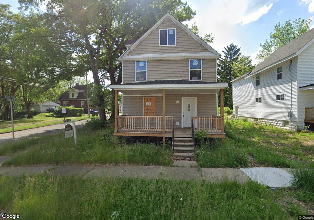
678 Moon St Akron, OH 44307
Sherbondy Hill NeighborhoodEstimated Value: $62,813 - $114,000
5
Beds
2
Baths
2,600
Sq Ft
$34/Sq Ft
Est. Value
About This Home
This home is located at 678 Moon St, Akron, OH 44307 and is currently estimated at $87,203, approximately $33 per square foot. 678 Moon St is a home located in Summit County with nearby schools including St. Bernard-St. Mary Elementary School.
Ownership History
Date
Name
Owned For
Owner Type
Purchase Details
Closed on
Mar 29, 2022
Sold by
Renard Jones
Bought by
Brown Mary B
Current Estimated Value
Purchase Details
Closed on
Mar 26, 2022
Sold by
Renard Jones
Bought by
Brown Mary B
Purchase Details
Closed on
Nov 11, 2015
Sold by
Jones Ernestine R
Bought by
Jones Rinald
Create a Home Valuation Report for This Property
The Home Valuation Report is an in-depth analysis detailing your home's value as well as a comparison with similar homes in the area
Home Values in the Area
Average Home Value in this Area
Purchase History
| Date | Buyer | Sale Price | Title Company |
|---|---|---|---|
| Brown Mary B | $5,000 | None Listed On Document | |
| Brown Mary B | $5,000 | None Listed On Document | |
| Jones Rinald | -- | Attorney |
Source: Public Records
Tax History
| Year | Tax Paid | Tax Assessment Tax Assessment Total Assessment is a certain percentage of the fair market value that is determined by local assessors to be the total taxable value of land and additions on the property. | Land | Improvement |
|---|---|---|---|---|
| 2025 | $765 | $3,963 | $3,903 | $60 |
| 2024 | $765 | $3,963 | $3,903 | $60 |
| 2023 | $765 | $10,133 | $3,903 | $6,230 |
| 2022 | $1,001 | $5,961 | $2,296 | $3,665 |
| 2021 | $948 | $5,961 | $2,296 | $3,665 |
| 2020 | $651 | $5,970 | $2,300 | $3,670 |
| 2019 | $1,146 | $8,010 | $2,680 | $5,330 |
| 2018 | $832 | $8,010 | $2,680 | $5,330 |
| 2017 | $882 | $8,010 | $2,680 | $5,330 |
| 2016 | $895 | $8,150 | $2,680 | $5,470 |
| 2015 | $882 | $8,150 | $2,680 | $5,470 |
| 2014 | $877 | $8,150 | $2,680 | $5,470 |
| 2013 | $864 | $8,150 | $2,680 | $5,470 |
Source: Public Records
Map
Nearby Homes
- 628 Bellevue Ave
- 777 Ruth Ave
- 817 Raymond St
- 924 Lane St
- 939 Lane St
- 577 Rhodes Ave
- 1041 Diagonal Rd
- 1132 Bristol Terrace
- 994 Moeller Ave
- 776 Krause Ct
- 985 Diana Ave
- 1011 Laurel Ave
- 614 East Ave
- 1225 Belleflower Rd
- 677 Crossings Ln
- 492 Douglas St
- 849 Glenn St
- 1021 La Croix Ave
- 443 W Thornton St
- 881 Stoner St
Your Personal Tour Guide
Ask me questions while you tour the home.