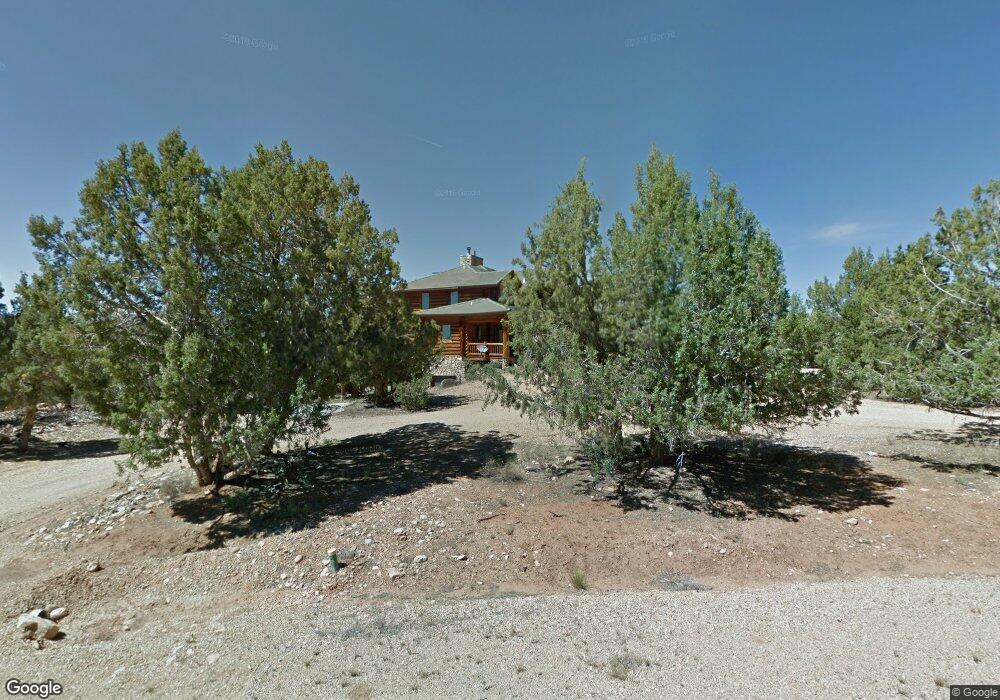
678 W Cedar Dr Orderville, UT 84758
Estimated Value: $888,000 - $1,909,405
5
Beds
6
Baths
8,614
Sq Ft
$162/Sq Ft
Est. Value
About This Home
This home is located at 678 W Cedar Dr, Orderville, UT 84758 and is currently estimated at $1,398,703, approximately $162 per square foot. 678 W Cedar Dr is a home located in Kane County with nearby schools including Valley Elementary School and Valley High School.
Ownership History
Date
Name
Owned For
Owner Type
Purchase Details
Closed on
Sep 4, 2020
Sold by
Ratzlaff Dorothy J
Bought by
Grossman Jason
Current Estimated Value
Purchase Details
Closed on
Oct 20, 2014
Bought by
Locey Beck and Locey Michelle
Purchase Details
Closed on
Oct 22, 2013
Sold by
Etitle Insurance Agency
Bought by
Nationstar Mortgage Llc
Purchase Details
Closed on
Jun 24, 2011
Sold by
Ratzlaff Lavern
Bought by
Yeley Scott and Choose One Trust
Purchase Details
Closed on
Apr 13, 2006
Sold by
Ratzlaff Lavern
Bought by
Ratzlaff Lavern and Ratzlaff Dorothy
Home Financials for this Owner
Home Financials are based on the most recent Mortgage that was taken out on this home.
Original Mortgage
$975,000
Interest Rate
6.2%
Purchase Details
Closed on
Apr 12, 2006
Sold by
Quarter Circle H Ranch Llc
Bought by
Ratzlaff Lavern
Home Financials for this Owner
Home Financials are based on the most recent Mortgage that was taken out on this home.
Original Mortgage
$975,000
Interest Rate
6.2%
Create a Home Valuation Report for This Property
The Home Valuation Report is an in-depth analysis detailing your home's value as well as a comparison with similar homes in the area
Home Values in the Area
Average Home Value in this Area
Purchase History
| Date | Buyer | Sale Price | Title Company |
|---|---|---|---|
| Grossman Jason | -- | -- | |
| Locey Beck | -- | -- | |
| Nationstar Mortgage Llc | -- | -- | |
| Yeley Scott | -- | -- | |
| Ratzlaff Lavern | -- | -- | |
| Ratzlaff Lavern | -- | -- |
Source: Public Records
Mortgage History
| Date | Status | Borrower | Loan Amount |
|---|---|---|---|
| Previous Owner | Ratzlaff Lavern | $975,000 |
Source: Public Records
Tax History Compared to Growth
Tax History
| Year | Tax Paid | Tax Assessment Tax Assessment Total Assessment is a certain percentage of the fair market value that is determined by local assessors to be the total taxable value of land and additions on the property. | Land | Improvement |
|---|---|---|---|---|
| 2025 | $7,581 | $949,267 | $136,624 | $812,643 |
| 2024 | $7,581 | $898,678 | $107,325 | $791,353 |
| 2023 | $6,980 | $860,994 | $107,325 | $753,669 |
| 2022 | $9,442 | $568,779 | $71,610 | $497,169 |
| 2021 | $9,723 | $869,366 | $47,600 | $821,766 |
| 2020 | $9,971 | $867,710 | $47,600 | $820,110 |
| 2019 | $10,278 | $867,710 | $47,600 | $820,110 |
| 2018 | $10,449 | $876,188 | $47,600 | $828,588 |
| 2017 | $10,650 | $876,188 | $47,600 | $828,588 |
| 2016 | $10,912 | $876,188 | $47,600 | $828,588 |
| 2015 | $10,355 | $876,188 | $47,600 | $828,588 |
| 2014 | $10,355 | $824,810 | $76,600 | $748,210 |
| 2013 | -- | $462,543 | $0 | $0 |
Source: Public Records
Map
Nearby Homes
- 1 Caruso Ln Unit 1
- 35 Prickley Pear Pinyon Pine Dr Unit 35
- 6 Caruso Ln Unit 6
- 12 Block "C" St Unit 8A-C12
- 12 Mountain View Dr Unit 12
- 5 Caruso Ln Unit 5
- 2 Caruso Ln Unit 2
- 255 White Oak St S Unit D24 25
- 3 Caruso Ln Unit 1
- 9 St
- 8 Caruso Ln Unit 5
- 11 Mountain View Dr Unit 11
- 100 Mineral Spring Rd
- 403 & 409 Mineral Springs Rd
- 291 Mineral Springs
- 0 W Squawberry Cir
- 0 W Pinyon Pine Dr Unit 1409030
- 0 W White Cliffs Dr Unit 1408846
- 7815 W Peaches Ln
- 2100 Buffalo Ridge
- 11630 Cedar Rd W Unit 20
- 5 Neilson Dr
- 20 Pinyon Pine Dr
- 67 Block "D" Unit 67
- 0 S See Remarks W Unit C-11 646039
- 46 Juniper Cir
- 58 Cedar Dr
- 708 Red Rock Dr
- 0 S See Remarks W Unit 40.0 893490
- 115 Long Valley Hwy
- 1495 S State St
- 385 W Whitecliffs Dr N
- 33 Prickley Pear Cir Unit 33
- 800 S Zion Ridge Rd Unit 54
- 385 White Cliffs Dr W
- 1 Cedar Dr
- 225 E 315 S
- 55 E Frost Ln
- 1460 S Valley View Dr W
- 10452 Zion Dr W Unit 27