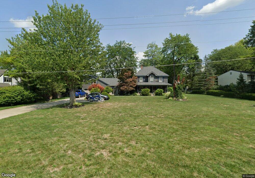
6780 Lambert Rd Orient, OH 43146
Estimated Value: $388,390 - $484,000
4
Beds
2
Baths
2,624
Sq Ft
$166/Sq Ft
Est. Value
About This Home
This home is located at 6780 Lambert Rd, Orient, OH 43146 and is currently estimated at $436,598, approximately $166 per square foot. 6780 Lambert Rd is a home located in Franklin County with nearby schools including Darbydale Elementary School, Hayes Intermediate School, and Pleasant View Middle School.
Ownership History
Date
Name
Owned For
Owner Type
Purchase Details
Closed on
Jun 19, 1990
Bought by
Kottman Bruce A
Current Estimated Value
Purchase Details
Closed on
Dec 6, 1988
Purchase Details
Closed on
Aug 1, 1975
Create a Home Valuation Report for This Property
The Home Valuation Report is an in-depth analysis detailing your home's value as well as a comparison with similar homes in the area
Home Values in the Area
Average Home Value in this Area
Purchase History
| Date | Buyer | Sale Price | Title Company |
|---|---|---|---|
| Kottman Bruce A | $92,000 | -- | |
| -- | -- | -- | |
| -- | $45,000 | -- |
Source: Public Records
Tax History
| Year | Tax Paid | Tax Assessment Tax Assessment Total Assessment is a certain percentage of the fair market value that is determined by local assessors to be the total taxable value of land and additions on the property. | Land | Improvement |
|---|---|---|---|---|
| 2025 | $5,790 | $129,500 | $26,950 | $102,550 |
| 2024 | $5,790 | $129,500 | $26,950 | $102,550 |
| 2023 | $5,185 | $129,500 | $26,950 | $102,550 |
| 2022 | $4,845 | $87,220 | $16,100 | $71,120 |
| 2021 | $4,931 | $87,220 | $16,100 | $71,120 |
| 2020 | $4,907 | $87,220 | $16,100 | $71,120 |
| 2019 | $4,923 | $76,830 | $14,000 | $62,830 |
| 2018 | $4,399 | $76,830 | $14,000 | $62,830 |
| 2017 | $4,885 | $76,830 | $14,000 | $62,830 |
| 2016 | $3,896 | $55,930 | $15,540 | $40,390 |
| 2015 | $3,895 | $55,930 | $15,540 | $40,390 |
| 2014 | $3,844 | $55,930 | $15,540 | $40,390 |
| 2013 | $2,161 | $62,125 | $17,255 | $44,870 |
Source: Public Records
Map
Nearby Homes
- 5326 Sandpiper Dr
- 6446 Harrisburg Pike
- 0 London Groveport Rd
- 1063 Springlawn Ave
- 7879 Railroad St
- 5514 Fairfield Rd
- 6106 London Groveport Rd Unit C9
- 6106 London Groveport Rd Unit C3
- 6946 Harrisburg London Rd
- 5981 Main St
- 6965 Gay Rd
- 6616 London Groveport Rd
- 6244 London Groveport Rd Unit 96
- 6244 London Groveport Rd Unit 8
- 5965 Harrisburg Georgesville Rd Unit 3
- 5382 Kirkwood Dr
- 5600 Bellview Dr
- 6774 Lewis Dr
- 6259 Cherokee Ln
- 5 Norton Rd
- 6794 Lambert Rd
- 6772 Lambert Rd
- 6795 Meadowlark Ct
- 6802 Lambert Rd
- 6809 Meadowlark Ct
- 6791 Lambert Rd
- 6829 Lambert Rd
- 0 Meadowlark Ct
- 5567 Pheasant Dr
- 6810 Lambert Rd
- 6819 Meadowlark Ct
- 5541 Pheasant Dr
- 6796 Meadowlark Ct
- 6781 Lambert Rd
- 6808 Meadowlark Ct
- 6816 Meadowlark Ct
- 5525 Pheasant Dr
- 6789 Bluebird Dr
- 5580 Pheasant Dr
- 6797 Bluebird Dr
Your Personal Tour Guide
Ask me questions while you tour the home.