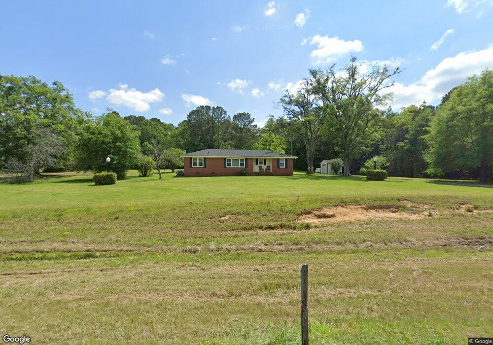
6780 Newnan Rd Brooks, GA 30205
Spalding County NeighborhoodEstimated Value: $221,886 - $279,000
2
Beds
1
Bath
1,435
Sq Ft
$171/Sq Ft
Est. Value
About This Home
This home is located at 6780 Newnan Rd, Brooks, GA 30205 and is currently estimated at $245,222, approximately $170 per square foot. 6780 Newnan Rd is a home located in Spalding County with nearby schools including Orrs Elementary School, Carver Road Middle School, and Griffin High School.
Ownership History
Date
Name
Owned For
Owner Type
Purchase Details
Closed on
Sep 25, 2019
Sold by
Camp Shirley Ann
Bought by
2183 North Mcdonough Road Llc
Current Estimated Value
Purchase Details
Closed on
Apr 8, 1993
Sold by
Sansom Bertha P
Bought by
Chastain Shirley A
Purchase Details
Closed on
Oct 12, 1992
Sold by
Leach Frances
Bought by
Chastain Shirley Ann
Purchase Details
Closed on
Apr 2, 1984
Sold by
Chastain Berthil E and Shirley Biles
Bought by
Chastain Shirley Ann
Create a Home Valuation Report for This Property
The Home Valuation Report is an in-depth analysis detailing your home's value as well as a comparison with similar homes in the area
Home Values in the Area
Average Home Value in this Area
Purchase History
| Date | Buyer | Sale Price | Title Company |
|---|---|---|---|
| 2183 North Mcdonough Road Llc | $135,000 | -- | |
| Chastain Shirley A | $1,700 | -- | |
| Chastain Shirley Ann | -- | -- | |
| Chastain Shirley Ann | -- | -- |
Source: Public Records
Tax History
| Year | Tax Paid | Tax Assessment Tax Assessment Total Assessment is a certain percentage of the fair market value that is determined by local assessors to be the total taxable value of land and additions on the property. | Land | Improvement |
|---|---|---|---|---|
| 2025 | $2,512 | $70,225 | $12,240 | $57,985 |
| 2024 | $2,485 | $70,225 | $12,240 | $57,985 |
| 2023 | $2,554 | $70,225 | $12,240 | $57,985 |
| 2022 | $2,063 | $56,725 | $10,080 | $46,645 |
| 2021 | $1,804 | $49,614 | $10,080 | $39,534 |
| 2020 | $1,810 | $49,614 | $10,080 | $39,534 |
| 2019 | $1,177 | $31,608 | $10,080 | $21,528 |
| 2018 | $1,124 | $29,420 | $10,080 | $19,340 |
| 2017 | $1,094 | $29,420 | $10,080 | $19,340 |
| 2016 | $1,113 | $29,420 | $10,080 | $19,340 |
| 2015 | $1,147 | $29,420 | $10,080 | $19,340 |
| 2014 | $1,058 | $29,420 | $10,080 | $19,340 |
Source: Public Records
Map
Nearby Homes
- 100 Fairview Rd
- 6475 Newnan Rd
- 161 Mockingbird Ln
- 460 Mask Rd
- 210 Mockingbird Ln
- LOT 8 Mask Road - Hanner's Farm S
- LOT 7 Mask Road - Hanner's Farm S
- LOT 5 Mask Road - Hanner's Farm N
- LOT 6 Mask Road - Hanner's Farm N
- LOT 4 Mask Road - Hanner's Farm N
- LOT 3 Mask Road - Hanner's Farm N
- 152 Carson Rd
- 0 Mask Rd Unit 10671477
- 160 Carrington Ln
- 130 Brooklet Way
- 240 Avalee Rd
- 9902 Highway 16
- NEXT TO 443 W Mcintosh Rd
- 0 W Mcintosh Rd Unit 10654779
- 395 W Mcintosh Rd
- 0 Highway 16 Unit 7204537
- 0 Highway 16 Unit B 8658419
- 0 Highway 16 Unit B 8498170
- 0 Poplar Dr Unit 3+/- 7570873
- 0 Poplar Dr Unit 7+/- 7621767
- 0 Poplar Dr Unit 7639362
- 0 Newnan Rd Unit 8356074
- 0 Newnan Rd Unit 7220003
- 0 Newnan Rd Unit 7269745
- 0 Newnan Rd Unit 7413070
- 0 Newnan Rd Unit 7205170
- 0 Newnan Rd Unit 7321537
- 0 Newnan Rd Unit 7413092
- 0 Newnan Rd Unit 7549997
- 0 Newnan Rd Unit 7622127
- 0 Newnan Rd Unit 8089138
- 0 Newnan Rd Unit 10319127
- 0 Newnan Rd Unit 8572718
- 180 Poplar Dr
- 6775 Newnan Rd
Your Personal Tour Guide
Ask me questions while you tour the home.