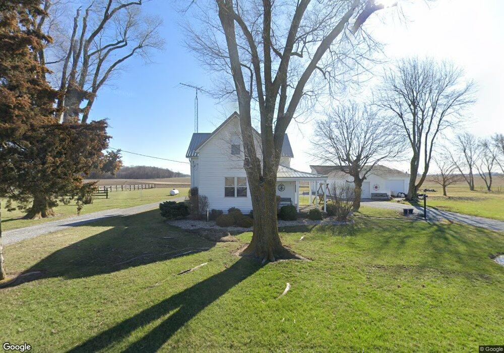
6780 Slabtown Rd Columbus Grove, OH 45830
Estimated Value: $165,000 - $216,000
4
Beds
1
Bath
1,551
Sq Ft
$126/Sq Ft
Est. Value
About This Home
This home is located at 6780 Slabtown Rd, Columbus Grove, OH 45830 and is currently estimated at $195,076, approximately $125 per square foot. 6780 Slabtown Rd is a home located in Allen County with nearby schools including Bath Elementary School, Bath Middle School, and Bath High School.
Ownership History
Date
Name
Owned For
Owner Type
Purchase Details
Closed on
Apr 19, 2023
Sold by
Ford Charles C and Ford Rhonda S
Bought by
Charles And Rhonda Ford Irrevocable Trust
Current Estimated Value
Purchase Details
Closed on
Aug 23, 2006
Sold by
Ford Charles C
Bought by
Ford Charles C and Ford Rhonda S
Purchase Details
Closed on
Sep 9, 1992
Bought by
Ford Charles C
Create a Home Valuation Report for This Property
The Home Valuation Report is an in-depth analysis detailing your home's value as well as a comparison with similar homes in the area
Home Values in the Area
Average Home Value in this Area
Purchase History
| Date | Buyer | Sale Price | Title Company |
|---|---|---|---|
| Charles And Rhonda Ford Irrevocable Trust | $137,900 | None Listed On Document | |
| Ford Charles C | -- | None Available | |
| Ford Charles C | $60,000 | -- |
Source: Public Records
Tax History Compared to Growth
Tax History
| Year | Tax Paid | Tax Assessment Tax Assessment Total Assessment is a certain percentage of the fair market value that is determined by local assessors to be the total taxable value of land and additions on the property. | Land | Improvement |
|---|---|---|---|---|
| 2024 | $2,416 | $58,870 | $10,710 | $48,160 |
| 2023 | $2,181 | $48,270 | $8,790 | $39,480 |
| 2022 | $2,213 | $48,270 | $8,790 | $39,480 |
| 2021 | $2,200 | $48,270 | $8,790 | $39,480 |
| 2020 | $1,978 | $39,940 | $8,160 | $31,780 |
| 2019 | $1,978 | $39,940 | $8,160 | $31,780 |
| 2018 | $1,944 | $39,940 | $8,160 | $31,780 |
| 2017 | $1,848 | $37,040 | $8,160 | $28,880 |
| 2016 | $1,820 | $37,040 | $8,160 | $28,880 |
| 2015 | $1,701 | $37,040 | $8,160 | $28,880 |
| 2014 | $1,701 | $35,360 | $8,160 | $27,200 |
| 2013 | $1,709 | $35,360 | $8,160 | $27,200 |
Source: Public Records
Map
Nearby Homes
- 220 Parklane Dr
- 201 Wall St
- 309 Wall St
- 6585 Ottawa Rd
- 300 Sweaney Ave
- 3456 Shearin Ave
- 108 Highland Lakes Dr
- 4619 N Thayer Rd
- 5025 N Cool Rd
- 0 N Dixie Hwy Unit 308796
- 0 N Dixie Hwy Unit 300253
- 1679 E Bluelick Rd
- 3270 Bonnieview Dr
- 3798 Kissing Hollow Dr
- 6601 N Napoleon Rd
- 207 W Prospect St
- 6476 Mickelson Ln
- 11059 Ottawa Rd
- 108 E Main St
- 4080 Brookshore Dr
- 6975 Slabtown Rd
- 6830 Slabtown Rd
- 6951 Slabtown Rd
- 6510 Slabtown Rd
- 6666 Slabtown Rd
- 6740 Slabtown Rd
- 6674 Slabtown Rd
- 7200 Slabtown Rd
- 7201 Slabtown Rd
- 7000 Slabtown Rd
- 0 Hook-Waltz Rd E
- 3060 Hook Waltz Rd E
- 3150 Hook Waltz Rd E
- 3182 Hook Waltz Rd E
- 3163 Hook Waltz Rd E
- 3205 Hook Waltz Rd E
- 3245 Hook Waltz Rd E
- 7650 Slabtown Rd