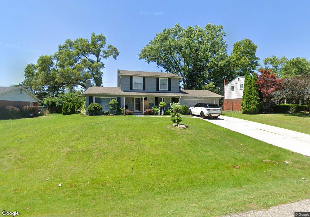
6784 Leslee Crest Dr West Bloomfield, MI 48322
Estimated Value: $337,111 - $428,000
3
Beds
2
Baths
1,695
Sq Ft
$221/Sq Ft
Est. Value
About This Home
This home is located at 6784 Leslee Crest Dr, West Bloomfield, MI 48322 and is currently estimated at $373,778, approximately $220 per square foot. 6784 Leslee Crest Dr is a home located in Oakland County with nearby schools including Sheiko Elementary School, West Bloomfield Middle School, and Bloomfield Maples Montessori.
Ownership History
Date
Name
Owned For
Owner Type
Purchase Details
Closed on
Jul 13, 2005
Sold by
Shammas Fatin
Bought by
Yalda Faeza Y
Current Estimated Value
Home Financials for this Owner
Home Financials are based on the most recent Mortgage that was taken out on this home.
Original Mortgage
$191,200
Outstanding Balance
$108,288
Interest Rate
7%
Mortgage Type
Fannie Mae Freddie Mac
Estimated Equity
$265,490
Purchase Details
Closed on
May 14, 2003
Sold by
Shammas Saad and Shammas Fatin
Bought by
Shammas Fatin
Purchase Details
Closed on
Jul 29, 1997
Sold by
Ateek Samar
Bought by
Shammas Saad
Home Financials for this Owner
Home Financials are based on the most recent Mortgage that was taken out on this home.
Original Mortgage
$130,000
Interest Rate
7.68%
Create a Home Valuation Report for This Property
The Home Valuation Report is an in-depth analysis detailing your home's value as well as a comparison with similar homes in the area
Home Values in the Area
Average Home Value in this Area
Purchase History
| Date | Buyer | Sale Price | Title Company |
|---|---|---|---|
| Yalda Faeza Y | $239,000 | -- | |
| Shammas Fatin | -- | -- | |
| Shammas Saad | $130,000 | -- |
Source: Public Records
Mortgage History
| Date | Status | Borrower | Loan Amount |
|---|---|---|---|
| Open | Yalda Faeza Y | $191,200 | |
| Previous Owner | Shammas Saad | $130,000 | |
| Closed | Yalda Faeza Y | $47,800 |
Source: Public Records
Tax History Compared to Growth
Tax History
| Year | Tax Paid | Tax Assessment Tax Assessment Total Assessment is a certain percentage of the fair market value that is determined by local assessors to be the total taxable value of land and additions on the property. | Land | Improvement |
|---|---|---|---|---|
| 2024 | $2,065 | $147,160 | $0 | $0 |
| 2022 | $1,977 | $123,640 | $35,130 | $88,510 |
| 2021 | $3,004 | $120,110 | $0 | $0 |
| 2020 | $1,938 | $118,730 | $35,130 | $83,600 |
| 2018 | $2,897 | $99,790 | $27,020 | $72,770 |
| 2015 | -- | $79,350 | $0 | $0 |
| 2014 | -- | $74,070 | $0 | $0 |
| 2011 | -- | $77,890 | $0 | $0 |
Source: Public Records
Map
Nearby Homes
- 6843 Leslee Crest Dr
- 7027 Beverly Crest Dr
- 6769 Heather Heath
- 6624 Mellow Wood Ln
- 6651 Hearthside Ct Unit 1
- 6614 Embers Ct
- 6621 Bellows Ct Unit 62
- 4161 Breckenridge Dr
- 6322 Pepper Hill St Unit 62
- 6222 Pepper Hill St
- 7023 Wild Ridge Ln
- 6145 Orchard Lake Rd Unit 204
- 6151 Orchard Lake Rd Unit 103
- 6109 Orchard Lake Rd Unit 101
- 4392 Gateway Cir Unit 59
- 7335 Coach Ln
- 7421 Heather Heath
- 6564 Alderley Way
- 6906 Pebblecreek Woods Dr
- 6904 Pebble Park Cir
- 6772 Leslee Crest Dr
- 6796 Leslee Crest Dr
- 6814 Leslee Crest Dr
- 6760 Leslee Crest Dr
- 6781 Leslee Crest Dr
- 6793 Leslee Crest Dr
- 6731 Leslee Crest Dr
- 6811 Leslee Crest Dr
- 6830 Leslee Crest Dr
- 6827 Leslee Crest Dr
- 6736 Leslee Crest Dr
- 6742 Beverly Crest Dr
- 6764 Beverly Crest Dr
- 6715 Leslee Crest Dr
- 6846 Leslee Crest Dr
- 6788 Beverly Crest Dr
- 6724 Leslee Crest Dr
- 6808 Beverly Crest Dr
- 0000 Vacant
- 6712 Leslee Crest Dr