Estimated Value: $372,000 - $420,000
3
Beds
3
Baths
1,603
Sq Ft
$251/Sq Ft
Est. Value
About This Home
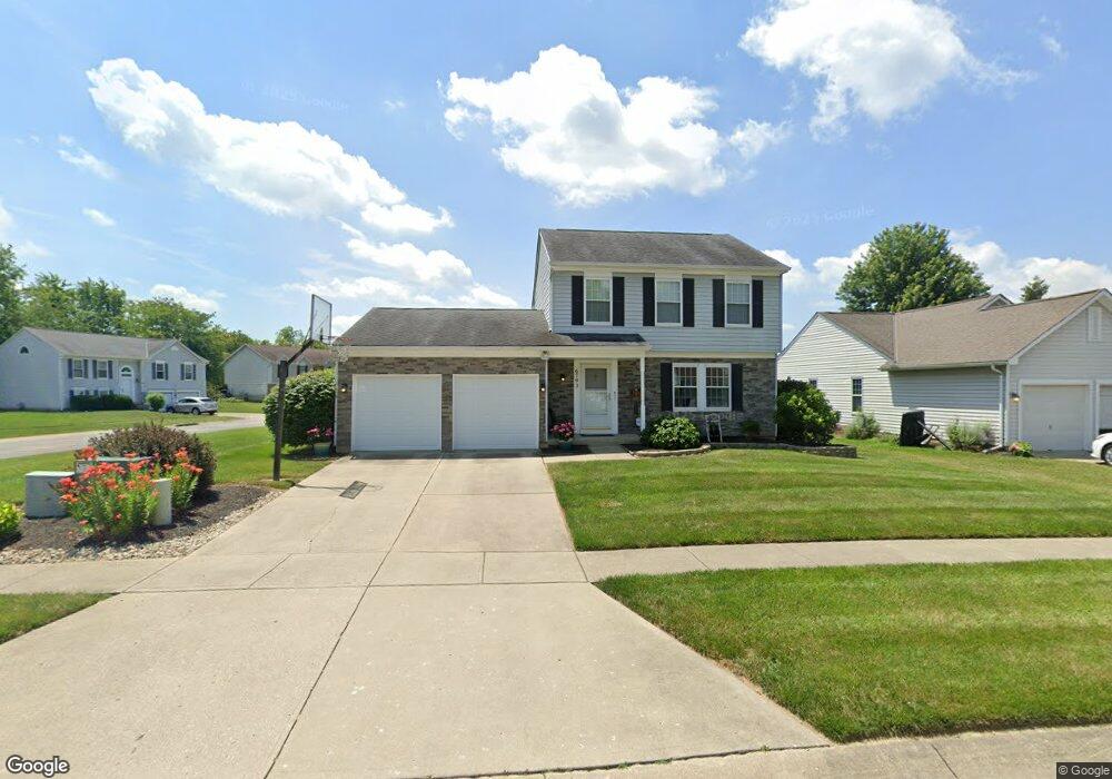
This home is located at 6793 Spring Arbor Dr, Mason, OH 45040 and is currently estimated at $401,765, approximately $250 per square foot. 6793 Spring Arbor Dr is a home located in Warren County with nearby schools including Mason Intermediate Elementary School, Mason Middle School, and William Mason High School.
Ownership History
Date
Name
Owned For
Owner Type
Purchase Details
Closed on
Oct 16, 2007
Sold by
Boyd James C
Bought by
Boyd Michelle L
Current Estimated Value
Purchase Details
Closed on
Sep 20, 1991
Sold by
Ryland Group & Inc
Bought by
Sieling and Sieling Mitchell W
Purchase Details
Closed on
Jul 9, 1991
Sold by
A J & R Development Co
Bought by
Ryland Group & Inc.
Purchase Details
Closed on
Mar 10, 1989
Sold by
A J & R Development Co
Bought by
A. J. & R. Development Co
Create a Home Valuation Report for This Property
The Home Valuation Report is an in-depth analysis detailing your home's value as well as a comparison with similar homes in the area
Home Values in the Area
Average Home Value in this Area
Purchase History
| Date | Buyer | Sale Price | Title Company |
|---|---|---|---|
| Boyd Michelle L | -- | Attorney | |
| Sieling | $101,100 | -- | |
| Ryland Group & Inc. | $19,500 | -- | |
| A. J. & R. Development Co | -- | -- |
Source: Public Records
Tax History
| Year | Tax Paid | Tax Assessment Tax Assessment Total Assessment is a certain percentage of the fair market value that is determined by local assessors to be the total taxable value of land and additions on the property. | Land | Improvement |
|---|---|---|---|---|
| 2025 | $4,693 | $109,390 | $31,500 | $77,890 |
| 2024 | $4,693 | $109,390 | $31,500 | $77,890 |
| 2023 | $4,379 | $84,087 | $16,800 | $67,287 |
| 2022 | $4,304 | $84,088 | $16,800 | $67,288 |
| 2021 | $4,094 | $84,088 | $16,800 | $67,288 |
| 2020 | $4,018 | $70,074 | $14,000 | $56,074 |
| 2019 | $3,725 | $70,074 | $14,000 | $56,074 |
| 2018 | $3,700 | $70,074 | $14,000 | $56,074 |
| 2017 | $3,264 | $56,333 | $12,807 | $43,526 |
| 2016 | $3,355 | $56,333 | $12,807 | $43,526 |
| 2015 | $3,102 | $56,333 | $12,807 | $43,526 |
| 2014 | $3,102 | $48,560 | $11,040 | $37,520 |
| 2013 | $3,108 | $61,590 | $14,000 | $47,590 |
Source: Public Records
Map
Nearby Homes
- 6978 Fallen Oaks Dr
- 6589 Quail Lake
- 6713 Quail Lake
- 8588 Charleston Creek Dr
- 6315 Greenwood Ct
- 6304 Trailwood Ct
- 6285 Greenwood Ct
- 8820 Butler Warren Rd
- 8830 Butler Warren Rd
- 9582 Opal Ln
- 9509 Butler Warren Rd
- 8608 Goldfinch Way
- 9286 Westchester Park Ct
- 7771 Jonathan Ct
- 8770 Cox Rd
- 1041 Sheffield Dr
- 8121 Barret Rd
- 8698 Cox Rd
- 8175 Sunburst Dr
- 9621 Iris Dr
- 6807 Spring Arbor Dr
- 8115 Indian Summer Way
- 6767 Spring Arbor Dr
- 6819 Spring Arbor Dr
- 6794 Spring Arbor Dr
- 8102 Indian Summer Way
- 6780 Spring Arbor Dr
- 8127 Indian Summer Way
- 6806 Spring Arbor Dr
- 8114 Indian Summer Way
- 6749 Spring Arbor Dr
- 6766 Spring Arbor Dr
- 6831 Spring Arbor Dr
- 6820 Spring Arbor Dr
- 8126 Indian Summer Way
- 6830 Autumn Mist Ct
- 6754 Spring Arbor Dr
- 6816 Autumn Mist Ct
- 6830 Spring Arbor Dr
- 6845 Spring Arbor Dr
Your Personal Tour Guide
Ask me questions while you tour the home.