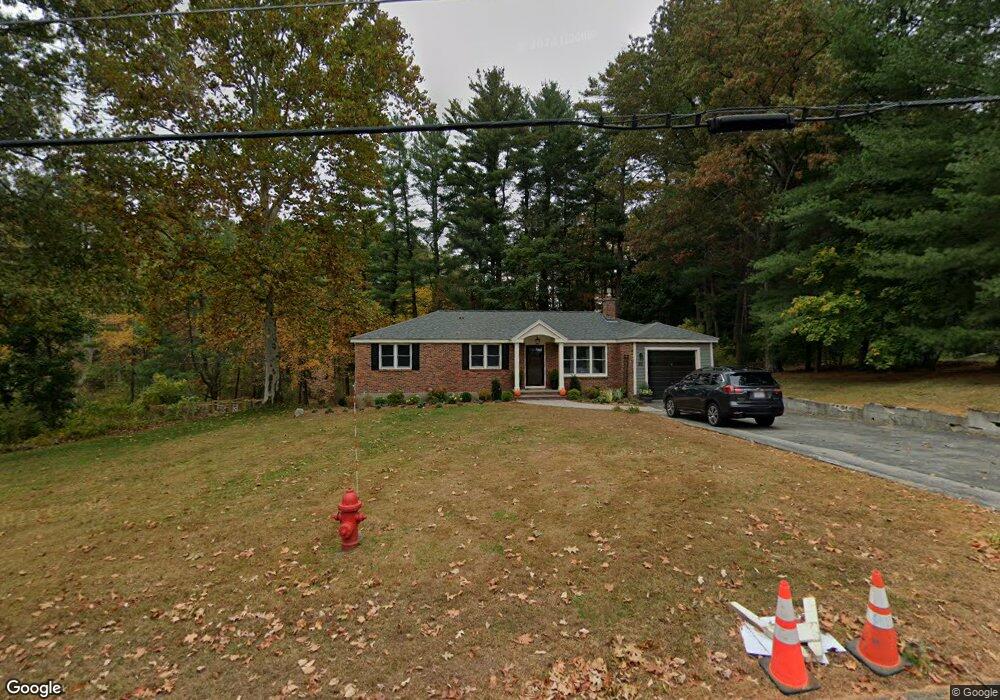
68 Bent Rd Sudbury, MA 01776
Estimated Value: $791,000 - $880,000
3
Beds
2
Baths
1,664
Sq Ft
$506/Sq Ft
Est. Value
About This Home
This home is located at 68 Bent Rd, Sudbury, MA 01776 and is currently estimated at $841,256, approximately $505 per square foot. 68 Bent Rd is a home located in Middlesex County with nearby schools including Israel Loring Elementary School, Ephraim Curtis Middle School, and Lincoln-Sudbury Regional High School.
Ownership History
Date
Name
Owned For
Owner Type
Purchase Details
Closed on
Aug 7, 2017
Sold by
Turner Brent R and Turner Joanna L
Bought by
Brent & Joanna Turner Lt
Current Estimated Value
Purchase Details
Closed on
May 6, 2010
Sold by
Clark-Mccann Patricia
Bought by
Turner Brent R and Turner Joanna L
Home Financials for this Owner
Home Financials are based on the most recent Mortgage that was taken out on this home.
Original Mortgage
$350,000
Interest Rate
5.03%
Mortgage Type
Purchase Money Mortgage
Purchase Details
Closed on
Jun 21, 2004
Sold by
Knight-Barnaby Deborah A
Bought by
Clark Dorothy
Purchase Details
Closed on
Mar 8, 1988
Sold by
Lonske Quinten T
Bought by
Barnaby Robert K
Create a Home Valuation Report for This Property
The Home Valuation Report is an in-depth analysis detailing your home's value as well as a comparison with similar homes in the area
Home Values in the Area
Average Home Value in this Area
Purchase History
| Date | Buyer | Sale Price | Title Company |
|---|---|---|---|
| Brent & Joanna Turner Lt | -- | -- | |
| Turner Brent R | $400,000 | -- | |
| Clark Dorothy | $435,000 | -- | |
| Barnaby Robert K | $202,500 | -- |
Source: Public Records
Mortgage History
| Date | Status | Borrower | Loan Amount |
|---|---|---|---|
| Previous Owner | Turner Brent R | $350,000 | |
| Previous Owner | Barnaby Robert K | $50,000 | |
| Previous Owner | Barnaby Robert K | $188,700 | |
| Previous Owner | Barnaby Robert K | $40,000 | |
| Previous Owner | Barnaby Robert K | $15,000 |
Source: Public Records
Tax History Compared to Growth
Tax History
| Year | Tax Paid | Tax Assessment Tax Assessment Total Assessment is a certain percentage of the fair market value that is determined by local assessors to be the total taxable value of land and additions on the property. | Land | Improvement |
|---|---|---|---|---|
| 2025 | $10,561 | $721,400 | $417,000 | $304,400 |
| 2024 | $10,199 | $698,100 | $404,800 | $293,300 |
| 2023 | $10,292 | $652,600 | $374,800 | $277,800 |
| 2022 | $10,018 | $555,000 | $344,000 | $211,000 |
| 2021 | $9,927 | $527,200 | $344,000 | $183,200 |
| 2020 | $9,727 | $527,200 | $344,000 | $183,200 |
| 2019 | $9,442 | $527,200 | $344,000 | $183,200 |
| 2018 | $8,969 | $500,200 | $366,800 | $133,400 |
| 2017 | $8,242 | $464,600 | $348,900 | $115,700 |
| 2016 | $7,946 | $446,400 | $335,600 | $110,800 |
| 2015 | $7,313 | $415,500 | $322,700 | $92,800 |
| 2014 | $7,291 | $404,400 | $313,200 | $91,200 |
Source: Public Records
Map
Nearby Homes
- 10 Hammond Cir
- 54 Stone Rd
- 0 Robbins Rd
- 20 Revolutionary Rd
- 46 Robert Best Rd
- 7 Saddle Ridge Rd
- 0 Boston Post Rd
- 40 Tall Pine Dr Unit 12
- 39 Austin Rd
- 89 Bridle Path
- 29 Kendall Rd
- 11 Red Horse Path
- 7 Adams Rd
- 14 Tanbark Rd
- 16 Meadowbrook Cir
- 73 Willow Rd
- 447 Peakham Rd
- 97 Barton Dr
- 123 Dutton Rd
- 128 Nobscot Rd